
Derby Line, Vermont
Encyclopedia
Derby Line is an incorporated village in the town of Derby
in Orleans County
, Vermont
, United States
, slightly north of the 45th parallel, the normal U.S.-Canadian boundary. The population was 776 at the 2000 census.
The village is located on the Canada-United States border
and is contiguous with the district of Rock Island in the town of Stanstead, Quebec
.
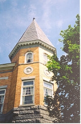
Notable buildings include the Haskell Free Library and Opera House
.
s and luxuriant farmland
, set before the distant vista of Lake Memphremagog
and the Green Mountains
.
Because of an erratic survey, the border separating Canada from the United States was drawn incorrectly by the surveyors in the 18th century, above the 45th parallel which was the agreed boundary. Derby Line was founded based on that line, above the 45th parallel. The boundary was confirmed by the Webster-Ashburton Treaty
in 1842.
Derby Line is known for the Haskell Free Library and Opera House
, deliberately constructed on the international border and opened in 1904. The donors were a binational couple: Carlos F. Haskell was a local American businessman who owned a number of sawmills, while Martha Stewart Haskell was Canadian. The intent was that people on both sides of the border would have use of the facility, which is now a designated historic site. Patrons of the library from either side of the border may use the facility without going through border security.
In some places, the international border runs through individual homes, so that meals prepared in one country are eaten in the other. An entire tool-and-die factory, once operated by the Butterfield division of Litton Industries
, is also divided in two by the border. The factory in Canada closed in 1982 after a lengthy strike by Canadian workers. The factory in Derby Line is still open, but was bought in 1988 by Group Tivoly, a cutting tools company based in France.
There are unusual ramifications living directly on the border of another country. For example, the Border Patrol has expressed a desire to close off streets which have historically run together with those of Stanstead. They are concerned about illegal immigration. In 2007, the village met with the Mayor and Council of Stanstead in joint session in Québec, to be addressed by the authorities. That is, the village trustee meeting was held in a foreign country, following Vermont procedural rules.
, the village has a total area of 0.7 square miles (1.8 km²), all land.
The village is the northern terminus of both Interstate 91
and US 5
.
of 2000, there were 776 people, 329 households, and 225 families residing in the village. The population density
was 1057.5 /sqmi. There were 364 housing units at an average density of 496.0 per square mile (192.5/km²). The racial makeup of the village was 96.78% White, 0.39% African American, 0.90% Native American, 0.64% Asian, and 1.29% from two or more races. Hispanic or Latino of any race were 0.13% of the population.
There were 329 households out of which 31.6% had children under the age of 18 living with them, 52.6% were married couples
living together, 11.6% had a female householder with no husband present, and 31.6% were non-families. 27.1% of all households were made up of individuals and 11.9% had someone living alone who was 65 years of age or older. The average household size was 2.36 and the average family size was 2.80.
In the village the population was spread out with 24.7% under the age of 18, 7.0% from 18 to 24, 25.6% from 25 to 44, 26.5% from 45 to 64, and 16.1% who were 65 years of age or older. The median age was 39 years. For every 100 females there were 92.1 males. For every 100 females age 18 and over, there were 86.0 males.
for the village was $15,202. About 11.4% of families and 12.8% of the population were below the poverty line, including 17.8% of those under age 18 and 11.9% of those age 65 or over.
Derby Line shares emergency crews with Stanstead. Each responds to calls on both sides of the border.
Derby, Vermont
Derby is a town in Orleans County, Vermont, United States. The population was 4,604 at the 2000 census. The town contains four unincorporated villages: Beebe Plain, Clyde Pond, Lake Salem and North Derby; and two incorporated villages: Derby Center and Derby Line...
in Orleans County
Orleans County, Vermont
Orleans County is one of the four northernmost counties in the U.S. state of Vermont. It borders Canada. In 2010, the population was 27,231. Its county seat is Newport. As in the rest of New England, few governmental powers have been granted to the county...
, Vermont
Vermont
Vermont is a state in the New England region of the northeastern United States of America. The state ranks 43rd in land area, , and 45th in total area. Its population according to the 2010 census, 630,337, is the second smallest in the country, larger only than Wyoming. It is the only New England...
, United States
United States
The United States of America is a federal constitutional republic comprising fifty states and a federal district...
, slightly north of the 45th parallel, the normal U.S.-Canadian boundary. The population was 776 at the 2000 census.
The village is located on the Canada-United States border
Canada-United States border
The Canada–United States border, officially known as the International Boundary, is the longest border in the world. The terrestrial boundary is 8,891 kilometers long, including 2,475 kilometres shared with Alaska...
and is contiguous with the district of Rock Island in the town of Stanstead, Quebec
Quebec
Quebec or is a province in east-central Canada. It is the only Canadian province with a predominantly French-speaking population and the only one whose sole official language is French at the provincial level....
.
Notable buildings include the Haskell Free Library and Opera House
Haskell Free Library and Opera House
The Haskell Free Library and Opera House is a neoclassical building that straddles the international border in Rock Island and Derby Line, Vermont...
.
History
The village was incorporated in 1791. It lies on an elevation at the far north of Derby, which was chartered on October 29, 1779 and first settled in 1795. By 1859, the area was noted for the beauty of its farmhouseFarmhouse
Farmhouse is a general term for the main house of a farm. It is a type of building or house which serves a residential purpose in a rural or agricultural setting. Most often, the surrounding environment will be a farm. Many farm houses are shaped like a T...
s and luxuriant farmland
Arable land
In geography and agriculture, arable land is land that can be used for growing crops. It includes all land under temporary crops , temporary meadows for mowing or pasture, land under market and kitchen gardens and land temporarily fallow...
, set before the distant vista of Lake Memphremagog
Lake Memphremagog
Lake Memphremagog is a fresh water glacial lake located between Newport, Vermont, United States and Magog, Quebec, Canada. The lake is long with 73 percent of the lake's surface area in Quebec, where it drains into the Magog River. However, three-quarters of its watershed, , is in Vermont. The...
and the Green Mountains
Green Mountains
The Green Mountains are a mountain range in the U.S. state of Vermont. The range extends approximately .-Peaks:The most notable mountains in the range include:*Mount Mansfield, , the highest point in Vermont*Killington Peak, *Mount Ellen,...
.
Because of an erratic survey, the border separating Canada from the United States was drawn incorrectly by the surveyors in the 18th century, above the 45th parallel which was the agreed boundary. Derby Line was founded based on that line, above the 45th parallel. The boundary was confirmed by the Webster-Ashburton Treaty
Webster-Ashburton Treaty
The Webster–Ashburton Treaty, signed August 9, 1842, was a treaty resolving several border issues between the United States and the British North American colonies...
in 1842.
Derby Line is known for the Haskell Free Library and Opera House
Haskell Free Library and Opera House
The Haskell Free Library and Opera House is a neoclassical building that straddles the international border in Rock Island and Derby Line, Vermont...
, deliberately constructed on the international border and opened in 1904. The donors were a binational couple: Carlos F. Haskell was a local American businessman who owned a number of sawmills, while Martha Stewart Haskell was Canadian. The intent was that people on both sides of the border would have use of the facility, which is now a designated historic site. Patrons of the library from either side of the border may use the facility without going through border security.
In some places, the international border runs through individual homes, so that meals prepared in one country are eaten in the other. An entire tool-and-die factory, once operated by the Butterfield division of Litton Industries
Litton Industries
Named after inventor Charles Litton, Sr., Litton Industries was a large defense contractor in the United States, bought by the Northrop Grumman Corporation in 2001.-History:...
, is also divided in two by the border. The factory in Canada closed in 1982 after a lengthy strike by Canadian workers. The factory in Derby Line is still open, but was bought in 1988 by Group Tivoly, a cutting tools company based in France.
There are unusual ramifications living directly on the border of another country. For example, the Border Patrol has expressed a desire to close off streets which have historically run together with those of Stanstead. They are concerned about illegal immigration. In 2007, the village met with the Mayor and Council of Stanstead in joint session in Québec, to be addressed by the authorities. That is, the village trustee meeting was held in a foreign country, following Vermont procedural rules.
Geography
According to the United States Census BureauUnited States Census Bureau
The United States Census Bureau is the government agency that is responsible for the United States Census. It also gathers other national demographic and economic data...
, the village has a total area of 0.7 square miles (1.8 km²), all land.
The village is the northern terminus of both Interstate 91
Interstate 91
Interstate 91 is an Interstate Highway in the New England region of the United States. It provides the primary north–south thoroughfare in the western part of New England...
and US 5
U.S. Route 5
U.S. Route 5 is a north–south United States highway running through the New England states of Connecticut, Massachusetts, and Vermont. Significant cities along the route include New Haven, Connecticut; Hartford, Connecticut; and Springfield, Massachusetts. From Hartford northward to St...
.
Demographics
As of the censusCensus
A census is the procedure of systematically acquiring and recording information about the members of a given population. It is a regularly occurring and official count of a particular population. The term is used mostly in connection with national population and housing censuses; other common...
of 2000, there were 776 people, 329 households, and 225 families residing in the village. The population density
Population density
Population density is a measurement of population per unit area or unit volume. It is frequently applied to living organisms, and particularly to humans...
was 1057.5 /sqmi. There were 364 housing units at an average density of 496.0 per square mile (192.5/km²). The racial makeup of the village was 96.78% White, 0.39% African American, 0.90% Native American, 0.64% Asian, and 1.29% from two or more races. Hispanic or Latino of any race were 0.13% of the population.
There were 329 households out of which 31.6% had children under the age of 18 living with them, 52.6% were married couples
Marriage
Marriage is a social union or legal contract between people that creates kinship. It is an institution in which interpersonal relationships, usually intimate and sexual, are acknowledged in a variety of ways, depending on the culture or subculture in which it is found...
living together, 11.6% had a female householder with no husband present, and 31.6% were non-families. 27.1% of all households were made up of individuals and 11.9% had someone living alone who was 65 years of age or older. The average household size was 2.36 and the average family size was 2.80.
In the village the population was spread out with 24.7% under the age of 18, 7.0% from 18 to 24, 25.6% from 25 to 44, 26.5% from 45 to 64, and 16.1% who were 65 years of age or older. The median age was 39 years. For every 100 females there were 92.1 males. For every 100 females age 18 and over, there were 86.0 males.
Personal income
The median income for a household in the village was $33,966, and the median income for a family was $37,375. Males had a median income of $30,208 versus $21,667 for females. The per capita incomePer capita income
Per capita income or income per person is a measure of mean income within an economic aggregate, such as a country or city. It is calculated by taking a measure of all sources of income in the aggregate and dividing it by the total population...
for the village was $15,202. About 11.4% of families and 12.8% of the population were below the poverty line, including 17.8% of those under age 18 and 11.9% of those age 65 or over.
Industry
A local subsidiary of an international tool manufacturer employs 180 workers from the area.Infrastructure
Drinking water for the adjacent towns of Derby Line and Stanstead is pumped from wells in Canada, stored in a reservoir in the United States and distributed through a system maintained by Canadians. Derby Line’s sewage makes a cross-border trip for treatment.Derby Line shares emergency crews with Stanstead. Each responds to calls on both sides of the border.