

Denfeld (Duluth)
Encyclopedia
The Denfeld neighborhood
is located within the West Duluth
district of Duluth
, Minnesota
, United States
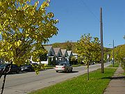
. It consists mostly of closely spaced single-family residential
homes, although a fair number of such houses have an area within the domicile registered as a rental unit. There are also a number of stores and businesses in the neighborhood concentrated along Grand Avenue.
 The Denfeld neighborhood, according to the city's map, is bounded by West 8th Street until Central Avenue; by Central Avenue until its intersection with Grand Avenue; Grand Avenue, until it crosses 46th Avenue West; and a divide near the Interstate 35
freeway until the railroad tracks near Carlton Street, the classic dividing-point between West Duluth
and rival neighborhood Lincoln Park
.
The Denfeld High School
serves most of West Duluth; six neighborhoods farther to the west; and both Lincoln Park
and Piedmont Heights
to the east; and is an architectural icon of the neighborhood.
Neighborhoods of Duluth, Minnesota
The city of Duluth, overlooking Lake Superior in the U.S. state of Minnesota has several distinct neighborhoods.- Central :*Canal Park*Central Hillside*Downtown Duluth*East Hillside*Park Point- Eastern Duluth :*Chester Park / UMD*Congdon Park...
is located within the West Duluth
West Duluth
West Duluth refers to an official neighborhood district in the west-central part of Duluth, Minnesota, United States.Grand Avenue, Central Avenue, Cody Street, and Interstate Highway 35 are four of the main arterial routes in the community.-Neighborhoods:...
district of Duluth
Duluth, Minnesota
Duluth is a port city in the U.S. state of Minnesota and is the county seat of Saint Louis County. The fourth largest city in Minnesota, Duluth had a total population of 86,265 in the 2010 census. Duluth is also the second largest city that is located on Lake Superior after Thunder Bay, Ontario,...
, Minnesota
Minnesota
Minnesota is a U.S. state located in the Midwestern United States. The twelfth largest state of the U.S., it is the twenty-first most populous, with 5.3 million residents. Minnesota was carved out of the eastern half of the Minnesota Territory and admitted to the Union as the thirty-second state...
, United States
United States
The United States of America is a federal constitutional republic comprising fifty states and a federal district...
. It consists mostly of closely spaced single-family residential
Residential area
A residential area is a land use in which housing predominates, as opposed to industrial and commercial areas.Housing may vary significantly between, and through, residential areas. These include single family housing, multi-family residential, or mobile homes. Zoning for residential use may permit...
homes, although a fair number of such houses have an area within the domicile registered as a rental unit. There are also a number of stores and businesses in the neighborhood concentrated along Grand Avenue.
Interstate 35 in Minnesota
In the U.S. state of Minnesota, Interstate 35 is a highway in southeast, east-central, and northeast Minnesota. The route runs north–south from the Iowa state line through the twin cities of Minneapolis and Saint Paul; where it splits into Interstates 35E and 35W; and ends in the city of...
freeway until the railroad tracks near Carlton Street, the classic dividing-point between West Duluth
West Duluth
West Duluth refers to an official neighborhood district in the west-central part of Duluth, Minnesota, United States.Grand Avenue, Central Avenue, Cody Street, and Interstate Highway 35 are four of the main arterial routes in the community.-Neighborhoods:...
and rival neighborhood Lincoln Park
Lincoln Park (Duluth)
Lincoln Park is one of the larger neighborhoods in the city of Duluth, Minnesota, United States.Lincoln Park is situated between Garfield Avenue to the ore docks at Carlton Street / 34th Avenue West. The neighborhood stretches up the hill to Skyline Parkway...
.
The Denfeld High School
Denfeld High School
Denfeld High School is one of two high schools in Duluth, Minnesota, along with East as of 2011. Denfeld and Central merged together during the 2010-2011 school year and are called Denfeld in the newly renovated building. Serving over 1000 students from grades nine to twelve, Denfeld High School...
serves most of West Duluth; six neighborhoods farther to the west; and both Lincoln Park
Lincoln Park (Duluth)
Lincoln Park is one of the larger neighborhoods in the city of Duluth, Minnesota, United States.Lincoln Park is situated between Garfield Avenue to the ore docks at Carlton Street / 34th Avenue West. The neighborhood stretches up the hill to Skyline Parkway...
and Piedmont Heights
Piedmont Heights (Duluth)
Piedmont Heights is a neighborhood in Duluth, Minnesota, United States.Piedmont Avenue, Chambersburg Avenue, and Morris Thomas Road are three of the main arterial routes in the community. The neighborhood is located between Skyline Parkway and Haines Road....
to the east; and is an architectural icon of the neighborhood.
Adjacent neighborhoods
- CodyCody (Duluth)The Cody neighborhood is located within the West Duluth district of Duluth, Minnesota, United States.Cody Street, Highland Street, 59th Avenue West, and West 8th Street are four of the main arterial routes in the community....
(north, west) - Lincoln ParkLincoln Park (Duluth)Lincoln Park is one of the larger neighborhoods in the city of Duluth, Minnesota, United States.Lincoln Park is situated between Garfield Avenue to the ore docks at Carlton Street / 34th Avenue West. The neighborhood stretches up the hill to Skyline Parkway...
(east) - OneotaOneota (Duluth)The Oneota neighborhood is located within the West Duluth district of Duluth, Minnesota, United States.Interstate Highway 35, 40th Avenue West, West Michigan Street, and Oneota Street are four of the main arterial routes in the community....
(south) - Spirit ValleySpirit Valley (Duluth)The Spirit Valley neighborhood and business district is located within the West Duluth district of Duluth, Minnesota, United States.Many stores and businesses in the neighborhood are concentrated along Grand Avenue, Central Avenue, Ramsey Street, and Bristol Street.The Spirit Valley business...
(south, west)
See also
- 40th Avenue West – County Road 91