

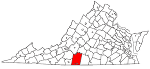
Danville, VA MSA
Encyclopedia
Virginia
The Commonwealth of Virginia , is a U.S. state on the Atlantic Coast of the Southern United States. Virginia is nicknamed the "Old Dominion" and sometimes the "Mother of Presidents" after the eight U.S. presidents born there...
as defined by the United States
United States
The United States of America is a federal constitutional republic comprising fifty states and a federal district...
Office of Management and Budget (OMB). As of the 2000 census
United States Census, 2000
The Twenty-second United States Census, known as Census 2000 and conducted by the Census Bureau, determined the resident population of the United States on April 1, 2000, to be 281,421,906, an increase of 13.2% over the 248,709,873 persons enumerated during the 1990 Census...
, the MSA had a population of 110,156 (though a July 1, 2007 estimate placed the population at 105,773).
MSA components
Note: Since a state constitutional change in 1871, all cities in VirginiaVirginia
The Commonwealth of Virginia , is a U.S. state on the Atlantic Coast of the Southern United States. Virginia is nicknamed the "Old Dominion" and sometimes the "Mother of Presidents" after the eight U.S. presidents born there...
are independent cities
Independent city
An independent city is a city that does not form part of another general-purpose local government entity. These type of cities should not be confused with city-states , which are fully sovereign cities that are not part of any other sovereign state.-Historical precursors:In the Holy Roman Empire,...
that are not located in any county. The OMB considers these independent cities to be county-equivalents for the purpose of defining MSAs in Virginia.
One county and one independent city are included in the Danville Metropolitan Statistical Area.
- Counties
- PittsylvaniaPittsylvania County, VirginiaAs of the census of 2000, there were 61,745 people, 24,684 households, and 18,216 families residing in the county. The population density was 64 people per square mile . There were 28,011 housing units at an average density of 29 per square mile...
- Pittsylvania
- Independent Cities
- DanvilleDanville, VirginiaDanville is an independent city in Virginia, United States, bounded by Pittsylvania County, Virginia and Caswell County, North Carolina. It was the last capital of the Confederate States of America. The Bureau of Economic Analysis combines the city of Danville with Pittsylvania county for...
- Danville
Incorporated places
- ChathamChatham, VirginiaChatham is a town in Pittsylvania County, Virginia, United States. Chatham's population was 1,338 at the 2000 census. It is included in the Danville, Virginia Metropolitan Statistical Area. Chatham is home to Chatham High School and Hargrave Military Academy. It is also home to Chatham Hall , an...
- DanvilleDanville, VirginiaDanville is an independent city in Virginia, United States, bounded by Pittsylvania County, Virginia and Caswell County, North Carolina. It was the last capital of the Confederate States of America. The Bureau of Economic Analysis combines the city of Danville with Pittsylvania county for...
(Principal city) - GretnaGretna, VirginiaGretna is a town in Pittsylvania County, Virginia, United States. The population was 1,257 at the 2000 census. It is part of the Danville Metropolitan Statistical Area.-Geography:Gretna is located at ....
- HurtHurt, VirginiaHurt is a town in Pittsylvania County, Virginia, United States. Hurt's population was 1,276 at the 2000 census. It is included in the Danville, Virginia Metropolitan Statistical Area.-Geography:Hurt is located at ....
Unincorporated places
- BlairsBlairs, VirginiaBlairs is a census-designated place in Pittsylvania County, Virginia, United States. The population as of the 2010 Census was 916.-Reference:*...
- Chalk LevelChalk Level, VirginiaChalk Level is an unincorporated community in Pittsylvania County, in the U.S. state of Virginia.-Reference:...
- Dry ForkDry Fork, Pittsylvania County, VirginiaDry Fork, Pittsylvania County is an unincorporated community in Pittsylvania County, in the U.S. state of Virginia.-Reference:...
- GritGrit, VirginiaGrit is an unincorporated community in Pittsylvania County, in the U.S. state of Virginia.-Reference:...
- Mount AiryMount Airy, Pittsylvania County, VirginiaMount Airy is an unincorporated community in northeastern Pittsylvania County, Virginia, United States. Its altitude is 643 feet , and it is located at , along State Route 40 between Gretna and Brookneal. It is included in the Danville, Virginia Metropolitan Statistical Area.-References:...
- Mt. HermonMount Hermon, VirginiaMount Hermon is a census-designated place in Pittsylvania County, Virginia, United States. The population as of the 2010 Census was 3,966.-References:*...
- Pickeral's Crossing
- PittsvillePittsville, VirginiaPittsville is an unincorporated community in Pittsylvania County, in the U.S. state of Virginia.- Economy :Pittsville has a small general store and a Post Office The primary industries are tied to agriculture, forest resources and real estate. There are many spectacular views of Smith Mountain,...
- RenanRenan, VirginiaRenan is an unincorporated community in the northeastern part of Pittsylvania County, Virginia, United States. It is included in the Danville, Virginia Metropolitan Statistical Area....
- RinggoldRinggold, VirginiaRinggold is an unincorporated community in Pittsylvania County in the U.S. state of Virginia with a postal zip code 24586.The community was named after Maj. Samuel Ringgold, a hero of the Battle of Palo Alto in the U.S.-Mexican War....
- SonansSonans, VirginiaSonans is an unincorporated community in Pittsylvania County, in the U.S. state of Virginia.-Reference:...
- Straightstone
- Whittles Depot
- TightsqueezeTightsqueeze, VirginiaTightsqueeze is an unincorporated community in the center of Pittsylvania County, Virginia, United States. It is included in the Danville, Virginia Metropolitan Statistical Area.-History:...
Demographics
As of the censusCensus
A census is the procedure of systematically acquiring and recording information about the members of a given population. It is a regularly occurring and official count of a particular population. The term is used mostly in connection with national population and housing censuses; other common...
of 2000, there were 110,156 people, 45,291 households, and 31,157 families residing within the MSA. The racial makeup of the MSA was 65.71% White, 32.64% African American, 0.15% Native American, 0.37% Asian, 0.02% Pacific Islander, 0.41% from other races
Race (United States Census)
Race and ethnicity in the United States Census, as defined by the Federal Office of Management and Budget and the United States Census Bureau, are self-identification data items in which residents choose the race or races with which they most closely identify, and indicate whether or not they are...
, and 0.70% from two or more races. Hispanic or Latino of any race were 1.24% of the population.
The median income for a household in the MSA was $31,027, and the median income for a family was $38,600. Males had a median income of $29,863 versus $21,383 for females. The per capita income
Per capita income
Per capita income or income per person is a measure of mean income within an economic aggregate, such as a country or city. It is calculated by taking a measure of all sources of income in the aggregate and dividing it by the total population...
for the MSA was $17,071.
See also
- List of U.S. Metropolitan Statistical Areas in Virginia
- Virginia census statistical areasVirginia census statistical areasThe United States Census Bureau has defined 2 Combined Statistical Areas , 11 Metropolitan Statistical Areas , and 4 Micropolitan Statistical Areas in the Commonwealth of Virginia. The following table describes these areas with the following information:*The name of the Combined Statistical Area...