

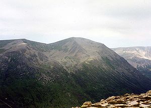
Càrn a' Mhàim
Encyclopedia
Scotland
Scotland is a country that is part of the United Kingdom. Occupying the northern third of the island of Great Britain, it shares a border with England to the south and is bounded by the North Sea to the east, the Atlantic Ocean to the north and west, and the North Channel and Irish Sea to the...
mountain situated in the inner part of the Cairngorms
Cairngorms
The Cairngorms are a mountain range in the eastern Highlands of Scotland closely associated with the mountain of the same name - Cairn Gorm.-Name:...
range, some 15 kilometres west of Braemar
Braemar
Braemar is a village in Aberdeenshire, Scotland, around west of Aberdeen in the Highlands. It is the closest significantly-sized settlement to the upper course of the River Dee sitting at an altitude of ....
in the county of Aberdeenshire
Aberdeenshire
Aberdeenshire is one of the 32 unitary council areas in Scotland and a lieutenancy area.The present day Aberdeenshire council area does not include the City of Aberdeen, now a separate council area, from which its name derives. Together, the modern council area and the city formed historic...
.
Overview
The mountain is located on one of the two long ridges which radiate south from Ben MacdhuiBen Macdhui (Scotland)
Ben Macdui is the second highest mountain in the United Kingdom after Ben Nevis, and the highest in the Cairngorms. After the defeat of Domnall mac Uilliam in 1187, Donnchad II, Earl of Fife, acquired Strathavon, territory stretching from Ballindalloch to Ben Macdui; because the mountain marked...
; it reaches a height of 1037 meters (3402 feet) and along with Macdhui and Derry Cairngorm
Derry Cairngorm
Derry Cairngorm is a Scottish mountain in the Cairngorms range, 14 kilometres north west of Braemar in the county of Aberdeenshire.- Overview :...
forms the central body of the Cairngorms that lie between the two major passes of the Lairig Ghru
Lairig Ghru
The Lairig Ghru is one of the mountain passes through the Cairngorms of Scotland.Like many traditional routes the ends of the route through the Lairig Ghru are like the ends of a frayed rope. From the south the Lairig Ghru can be approached from Braemar though Glen Lui, or Glen Dee, and from Blair...
and the Lairig an Laoigh. The mountain is notable in that it has the only ridge walk of any significance in the Cairngorms range. Its name translates from the Gaelic
Scottish Gaelic language
Scottish Gaelic is a Celtic language native to Scotland. A member of the Goidelic branch of the Celtic languages, Scottish Gaelic, like Modern Irish and Manx, developed out of Middle Irish, and thus descends ultimately from Primitive Irish....
as "Cairn of the large rounded hill", when viewed from the south it does appear as rounded, although in reality the mountain is a north-south oriented ridge. Another possible meaning of the name is "Hill of the Pass" derived from mam or mhaim, meaning pass. The mountain stands at the entrance of the Lairig Ghru pass, so this meaning is a possibility.
Geography
Càrn a' Mhàim's slopes fall away steeply from the summit in three directions. The western flanks fall precipitously to the Lairig Ghru while the eastern slopes descent more gently to the valley of the Luibeg Burn. To the south east there is a broad ridge which ends in the crags of Coire na Poite. To the north is a narrow two kilometre-long crest which is often labeled as the only noteworthy ridge in the Cairngorms; it connects the mountain to Ben Macdhui.The journey to Ben Macdhui is a hard walk which goes along Càrn a' Mhàim's northern ridge with Irvine Butterfield saying:
It drops down to the col
Mountain pass
A mountain pass is a route through a mountain range or over a ridge. If following the lowest possible route, a pass is locally the highest point on that route...
between the two mountains at a height of around 800 meters. From there it is a hard climb of 500 metres up the side of the Allt Clach nan Tàillear (The Tailor's Burn) with much boulder-hopping to reach the summit plateau of Macdhui.