

Cunninghamhead railway station
Encyclopedia
Cunninghamhead railway station was a railway station
serving Cunninghamhead Estate, the village of Crossroads (renamed to Cunninghamhead
), North Ayrshire
and the town of Stewarton
, East Ayrshire
, Scotland
. The station was originally part of the Glasgow, Paisley, Kilmarnock and Ayr Railway
.
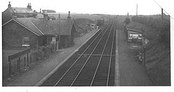
, with two platforms and a signal box a short distance away. A rectangular sandstone shelter or store was situated on the northbound platform. Maps and photographs of Cunninghamhead show a substantial goods shed and a small weigh house with extensive cattle docks and other sidings. A Stationmaster's house was also present. The 1860 map records the electric telegraph belonging to the railway, this being a novelty in those days. A single running line and some sidings were all that remained here at closure.
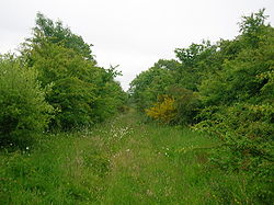
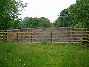
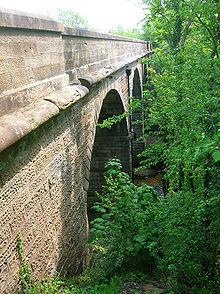
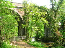
 Very little remains today of the station site apart from the substantial cattle docks, parts of the station garden and the remains of a signal box. The nearby viaduct over the Annick Water is in excellent condition having been restored in 2005 / 2006. A footpath had run down from Cunninghamhead House to the station, reaching the road via an embankment in the field and passing through the fine sandstone wall which runs down from the bridge. The footpath 'gap' was closed in 2006 when this wall was rebuilt. Locals living at Cunninghamhead and Byres Farm relate that the station was known locally as 'Kerr's Halt' in the 1940s as the two Kerr family sisters from the Cunninghamhead Estate
used this station frequently.
and the British Empire
beyond. The Ayrshire cattle
breed were even sent from nearby Wheatrig Farm to restock the Falkland Islands after the war with Argentina
. A tragic accident is recorded in which an Elizabeth Kennedy lost both arms when she fell beneath a train here at sometime around 1885 to 1900. A dedicated horse drawn carriage service operated to carry passengers from Stewarton to the station for a number of years.
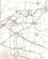
 A mineral line running from near the station passed Overtoun Farm and running towards Southhook and Springside is shown in 1895, but is not present in the 1912 OS. Overton Row is marked on the 1912 OS with a school, coal; pit, clayworks and a number of other buildings, but by 1928 only the school building remained, only the foundation being visible today (2007). A short siding, seemingly to supply domestic coal to the Annick Lodge Estate, is indicated in 1860, but this was not marked in 1912 or subsequently.
 Above the station in 1860 was a cottage, called Standalane, lying on the left hand side of the old road to Springside, which is now closed, as a new road has been made closer to Irvine for traffic safety reasons. Standalane's position in 1897 is shown as being almost on the mineral line; The OS maps after this date do not show it at all. In 1776, plate 45 of G. Taylor and A. Skinner's 'Survey and maps of the roads of North Britain or Scotland' shows 'Standalone' marked, so the dwelling was of some significant antiquity. The old sandstone parapet of the bridge overlooking the site of Cunninghamhead
railway station has many naive carvings on it, made over the years by local children and pupils from the local school as they waited and watched the old steam and diesel trains going by.
 Nearby a network of mineral railways linked the collieries at Annick Lodge, Perceton
and elsewhere to the main railway network. Annick Colliery and the coal pit at East Wood linked directly to the G&SWR main line, the Annick Colliery lay near to the road to Holehouse Farm. Perceton Colliery, near Law Farm, linked directly to Irvine on the line from Busbie (or Busby) Junction at Crosshouse. A Fireclay Works was situated close to Springside where a coal pit was also located. Numerous old coal pits dot the area.
Train station
A train station, also called a railroad station or railway station and often shortened to just station,"Station" is commonly understood to mean "train station" unless otherwise qualified. This is evident from dictionary entries e.g...
serving Cunninghamhead Estate, the village of Crossroads (renamed to Cunninghamhead
Cunninghamhead
Cunninghamhead is a hamlet in North Ayrshire, Scotland. It was the centre of the lands of Cunninghamhead, Perceton and Annick Lodge in Cunninghame...
), North Ayrshire
North Ayrshire
North Ayrshire is one of 32 council areas in Scotland with a population of roughly 136,000 people. It is located in the south-west region of Scotland, and borders the areas of Inverclyde to the north, Renfrewshire to the north-east and East Ayrshire and South Ayrshire to the East and South...
and the town of Stewarton
Stewarton
Stewarton is a town in East Ayrshire, Scotland. In comparison to the neighbouring towns of Kilmaurs, Fenwick, Dunlop and Lugton, it is a relatively large town, with a population of over 6,500. It is 300 feet above sea level.Groome, Francis H. . Ordnance Gazetteer of Scotland. Pub. Caxton. London....
, East Ayrshire
East Ayrshire
East Ayrshire is one of 32 council areas of Scotland. It borders on to North Ayrshire, East Renfrewshire, South Lanarkshire, South Ayrshire and Dumfries and Galloway...
, Scotland
Scotland
Scotland is a country that is part of the United Kingdom. Occupying the northern third of the island of Great Britain, it shares a border with England to the south and is bounded by the North Sea to the east, the Atlantic Ocean to the north and west, and the North Channel and Irish Sea to the...
. The station was originally part of the Glasgow, Paisley, Kilmarnock and Ayr Railway
Glasgow, Paisley, Kilmarnock and Ayr Railway
The Glasgow, Paisley, Kilmarnock and Ayr Railway was a railway in Scotland that provided train services between Glasgow, Kilmarnock and Ayr. For a short period, it also provided West Coast services between Glasgow and London. Opened in stages between 1839 and 1848, the line ran from Paisley in the...
.
History
The station opened on 4 April 1843 as Stewarton, (despite being several miles away from Stewarton itself), however closed on 22 May 1848. The station reopened again in November 1850, and was eventually renamed Cunninghamhead on 1 September 1873. The station closed permanently to passengers on 1 January 1955, although the line was still in use by freight trains and diverted passenger trains until 23 October 1973. Freight services had been withdrawn in February 1960.Description
A moderately sized station building served CunninghamheadCunninghamhead
Cunninghamhead is a hamlet in North Ayrshire, Scotland. It was the centre of the lands of Cunninghamhead, Perceton and Annick Lodge in Cunninghame...
, with two platforms and a signal box a short distance away. A rectangular sandstone shelter or store was situated on the northbound platform. Maps and photographs of Cunninghamhead show a substantial goods shed and a small weigh house with extensive cattle docks and other sidings. A Stationmaster's house was also present. The 1860 map records the electric telegraph belonging to the railway, this being a novelty in those days. A single running line and some sidings were all that remained here at closure.
Cunninghamhead Estate
The Cunninghamhead Estate is in the 21st century mainly a residential caravan park with two private residences near Irvine, Scotland. It was once a private estate, owned by a sequence of recorded families since around 1418. The Mansion House, one of Britain's lost houses, was built in 1747; it was...
used this station frequently.
Additional information
Many of the Ayrshire or Cunninghame breed of cattle were sent from here to all parts of the United KingdomUnited Kingdom
The United Kingdom of Great Britain and Northern IrelandIn the United Kingdom and Dependencies, other languages have been officially recognised as legitimate autochthonous languages under the European Charter for Regional or Minority Languages...
and the British Empire
British Empire
The British Empire comprised the dominions, colonies, protectorates, mandates and other territories ruled or administered by the United Kingdom. It originated with the overseas colonies and trading posts established by England in the late 16th and early 17th centuries. At its height, it was the...
beyond. The Ayrshire cattle
Ayrshire cattle
The Ayrshire cattle is a breed of dairy cattle originated from Ayrshire in Scotland. The average mature Ayrshire cow weighs 1,000-1,300 pounds . Ayrshires have red markings. The red can be an orange to a dark brown, with or without coloured legs. They are known for low somatic cell counts,...
breed were even sent from nearby Wheatrig Farm to restock the Falkland Islands after the war with Argentina
Argentina
Argentina , officially the Argentine Republic , is the second largest country in South America by land area, after Brazil. It is constituted as a federation of 23 provinces and an autonomous city, Buenos Aires...
. A tragic accident is recorded in which an Elizabeth Kennedy lost both arms when she fell beneath a train here at sometime around 1885 to 1900. A dedicated horse drawn carriage service operated to carry passengers from Stewarton to the station for a number of years.
Cunninghamhead
Cunninghamhead is a hamlet in North Ayrshire, Scotland. It was the centre of the lands of Cunninghamhead, Perceton and Annick Lodge in Cunninghame...
railway station has many naive carvings on it, made over the years by local children and pupils from the local school as they waited and watched the old steam and diesel trains going by.
Perceton
Perceton is a medieval settlement and estate in North Ayrshire, Scotland, near the town of Irvine. The old church in Perceton is one of the oldest buildings in the Irvine district...
and elsewhere to the main railway network. Annick Colliery and the coal pit at East Wood linked directly to the G&SWR main line, the Annick Colliery lay near to the road to Holehouse Farm. Perceton Colliery, near Law Farm, linked directly to Irvine on the line from Busbie (or Busby) Junction at Crosshouse. A Fireclay Works was situated close to Springside where a coal pit was also located. Numerous old coal pits dot the area.