
Crown Range
Encyclopedia
Mountain
Image:Himalaya_annotated.jpg|thumb|right|The Himalayan mountain range with Mount Everestrect 58 14 160 49 Chomo Lonzorect 200 28 335 52 Makalurect 378 24 566 45 Mount Everestrect 188 581 920 656 Tibetan Plateaurect 250 406 340 427 Rong River...
s lies to the east of the Wakatipu Basin
Wakatipu Basin
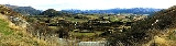
The Wakatipu Basin is a plain surrounded by mountains in inland Otago, New Zealand.At the south west corner is found the Queenstown suburb of Frankton and Queenstown Airport...
in Otago
Otago
Otago is a region of New Zealand in the south of the South Island. The region covers an area of approximately making it the country's second largest region. The population of Otago is...
, New Zealand
New Zealand
New Zealand is an island country in the south-western Pacific Ocean comprising two main landmasses and numerous smaller islands. The country is situated some east of Australia across the Tasman Sea, and roughly south of the Pacific island nations of New Caledonia, Fiji, and Tonga...
. It is noted for two features, the Cardrona Alpine Resort
Cardrona Alpine Resort
Cardrona Alpine Resort is a ski resort in New Zealand's South Island. The skifield ranges from 1,260m to 1,894m. The distribution of slopes is 25% beginner, 50% intermediate and 25% advanced. There are 2 detachable quad chairlifts and 2 fixed-grip quad chairlift, 2 "magic carpet" learner lifts and...
, on the slopes of the 1900 metre Mt. Cardrona, and a highway, known as the Crown Range Road, which winds steeply between Arrow Junction, south of Arrowtown
Arrowtown
Arrowtown is a historic gold mining town in the Otago region of the South Island of New Zealand. Arrowtown is located on the banks of the Arrow River approximately 5 km from State Highway 6...
, and Wanaka
Wanaka
Wanaka is a town in the Otago region of the South Island of New Zealand. It is situated at the southern end of Lake Wanaka, adjacent to the outflow of the lake to the Clutha River. It is the gateway to Mount Aspiring National Park. Wanaka is primarily a resort town but has both summer and winter...
to the north. This is one of the highest sealed roads in New Zealand.
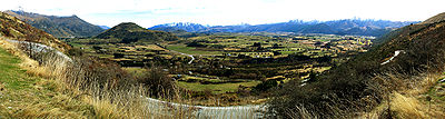
Traveling from Arrowtown towards Cromwell the Crown Range Road starts at the bottom of the Zig zag. This steep and winding climb goes to the Crown Terrace. The Crown Terrace is a large flat and fertile area capable of growing grain crops. The road off to the left is to Glencoe Station (Glencoe Road) and at the end of the Crown Terrace is the Eastburn Road to Eastburn Station. Glencoe Station is the large high country ranch behind Arrowtown. Eastburn Station is also large and runs from the Glencoe boundary almost to Cardrona, New Zealand
Cardrona, New Zealand
Cardrona is the name of a locality, skifield and beer in New Zealand. Established as a gold rush township in the 1860s on the banks of the small river of the same name, it is known for its distinctive hotel of gold rush vintage which is on the opposite side of the river to the original township of...
.
Just past the Eastburn Road the road twists and climbs up to the Crown Saddle. The bronze plaque at the Crown Range Road Summit confirms that this historic pass, at 1076 m (3530 ft) is one of the highest sealed (paved) roads in all of New Zealand (2m higher than the Desert Road summit on State Highway 1 in the North Island
North Island
The North Island is one of the two main islands of New Zealand, separated from the much less populous South Island by Cook Strait. The island is in area, making it the world's 14th-largest island...
). Before being revoked in the late 1990s the road was gazetted State Highway 89. Eastburn Station has provided a number of viewing areas. The distant views down and over Lake Hayes, Arrowtown and the airport to Queenstown are stunning in any conditions. From the Crown Saddle the road follows the Cardrona creek, then stream which becomes the Cardrona River down the iconic snow tussock valley until it opens out at the small settlement of Cardrona.
The area was heavily populated during the Central Otago goldrush of the 1860s, the town of Cardrona, now little more than a dot on the map, briefly having a population of several thousand prospector
Prospecting
Prospecting is the physical search for minerals, fossils, precious metals or mineral specimens, and is also known as fossicking.Prospecting is a small-scale form of mineral exploration which is an organised, large scale effort undertaken by mineral resource companies to find commercially viable ore...
s. There are visible remains of gold prospecting beside the Crown Range Road over the Saddle on the west bank opposite the East Burn (stream) 2 miles over the saddle. Also 6 miles down from the Saddle on the east bank.