
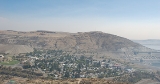
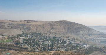
Coulee Dam, Washington
Encyclopedia
U.S. state
A U.S. state is any one of the 50 federated states of the United States of America that share sovereignty with the federal government. Because of this shared sovereignty, an American is a citizen both of the federal entity and of his or her state of domicile. Four states use the official title of...
of Washington. The Douglas County portion of Coulee Dam is part of the Wenatchee
Wenatchee, Washington
Wenatchee is located in North Central Washington and is the largest city and county seat of Chelan County, Washington, United States. The population within the city limits in 2010 was 31,925...
–East Wenatchee
East Wenatchee, Washington
East Wenatchee is a city in Douglas County, Washington, United States along the northern banks of the Columbia River. The population at the 2010 census was 13,190, a 129.1% increase over the 2000 census....
, Washington Metropolitan Statistical Area
Wenatchee metropolitan area
The Wenatchee–East Wenatchee Metropolitan Statistical Area, as defined by the United States Census Bureau, is an area consisting of two counties in Washington, anchored by the cities of Wenatchee and East Wenatchee...
. The population was 1,098 as of the 2010 census.
History
Coulee Dam was originally founded by the U.S. Bureau of Reclamation in 1933, to serve as headquarters for the construction of the Grand Coulee DamGrand Coulee Dam
Grand Coulee Dam is a gravity dam on the Columbia River in the U.S. state of Washington built to produce hydroelectric power and provide irrigation. It was constructed between 1933 and 1942, originally with two power plants. A third power station was completed in 1974 to increase its energy...
. The Okanogan County portion was known as Mason City, location of the head contractor. The Portions in Douglas and Grant Counties was known as Engineers Town and was government owned. In 1942 with the end of the contract in sight, CBI transferred control of Mason City to the over to the Municipal Division of the Columbia Basin Project. In 1948 Mason City was incorporated into Coulee Dam. Government began the process of selling the town to the public in 1957 finishing in 1959. Coulee Dam was officially incorporated as a town on February 26, 1959.
It is the headquarters of Lake Roosevelt National Recreation Area
Lake Roosevelt National Recreation Area
Lake Roosevelt National Recreation Area is a U.S. National Recreation Area of the National Park Service that encompasses the long Franklin D. Roosevelt Lake between Grand Coulee Dam and Northport, Washington, in eastern Washington state. It is a popular boating, fishing, hunting, camping, and...
, and home of one of the world's largest man-made piles of sand, a 12000000 cubic yards (9,174,658.3 m³), 230 feet (70.1 m)-high hill remaining from dam construction.
Geography
Coulee Dam is located at 47°58′6"N 118°58′41"W (47.968467, -118.978162).The Okanogan County portion lies within the Colville Indian Reservation
Colville Indian Reservation
The Colville Indian Reservation is an Indian reservation in the north-central part of the U.S. state of Washington, inhabited and managed by the Confederated Tribes of the Colville Reservation, which is recognized by the United States of America as an American Indian Tribe...
, and forms the southern limit of the Okanogan Highlands
Okanagan Highland
The Okanagan Highland is a plateau-like hilly area in British Columbia, Canada, and the U.S. state of Washington . It lies between the Okanagan Valley on its west and the Kettle River on its east, and geologically is more or less an extension of the Thompson Plateau, which lies west of the Okanagan...
.
According to the United States Census Bureau
United States Census Bureau
The United States Census Bureau is the government agency that is responsible for the United States Census. It also gathers other national demographic and economic data...
, the town has a total area of 0.7 square mile (1.9 km²), of which 0.7 square mile (1.8 km²) is land and 0.1 square mile (0.1 km²) (6.85%) is water.
Demographics
As of the censusCensus
A census is the procedure of systematically acquiring and recording information about the members of a given population. It is a regularly occurring and official count of a particular population. The term is used mostly in connection with national population and housing censuses; other common...
of 2000, there were 1,044 people, 448 households, and 305 families residing in the town. The population density
Population density
Population density is a measurement of population per unit area or unit volume. It is frequently applied to living organisms, and particularly to humans...
was 1,532.5 people per square mile (592.8/km²). There were 499 housing units at an average density of 732.5 per square mile (283.3/km²). The racial makeup of the town was 64.56% White, 0.29% African American, 29.12% Native American, 0.48% Asian, 0.57% from other races
Race (United States Census)
Race and ethnicity in the United States Census, as defined by the Federal Office of Management and Budget and the United States Census Bureau, are self-identification data items in which residents choose the race or races with which they most closely identify, and indicate whether or not they are...
, and 4.98% from two or more races. Hispanic or Latino of any race were 2.78% of the population.
There were 448 households out of which 25.7% had children under the age of 18 living with them, 52.0% were married couples
Marriage
Marriage is a social union or legal contract between people that creates kinship. It is an institution in which interpersonal relationships, usually intimate and sexual, are acknowledged in a variety of ways, depending on the culture or subculture in which it is found...
living together, 11.4% had a female householder with no husband present, and 31.7% were non-families. 27.7% of all households were made up of individuals and 13.8% had someone living alone who was 65 years of age or older. The average household size was 2.32 and the average family size was 2.74.
In the town the population was spread out with 22.9% under the age of 18, 7.1% from 18 to 24, 20.7% from 25 to 44, 29.0% from 45 to 64, and 20.3% who were 65 years of age or older. The median age was 44 years. For every 100 females there were 93.3 males. For every 100 females age 18 and over, there were 90.3 males.
The median income for a household in the town was $37,391, and the median income for a family was $45,066. Males had a median income of $38,000 versus $22,500 for females. The per capita income
Per capita income
Per capita income or income per person is a measure of mean income within an economic aggregate, such as a country or city. It is calculated by taking a measure of all sources of income in the aggregate and dividing it by the total population...
for the town was $18,791. About 6.7% of families and 9.8% of the population were below the poverty line, including 14.9% of those under age 18 and 11.0% of those age 65 or over.