
Coopers Rock State Forest
Encyclopedia
Coopers Rock State Forest is a 12747 acres (52 km²) state forest
in Monongalia
and Preston
counties in the U.S. state
of West Virginia
. Its southern edge abuts Cheat Lake
and the canyon
section of Cheat River
, a popular whitewater rafting river in the eastern US.
Much of Coopers Rock was originally developed by projects of the Civilian Conservation Corps
from 1936-1942. Many of these structures, including durable rustic picnic shelters made of American chestnut
, exist today and are listed on the National Register of Historic Places
.
. The northern portion of the forest is managed by forestry program at West Virginia University
and is lesser-developed. The southern part is jointly managed by the West Virginia Division of Natural Resources
and West Virginia Division of Forestry
. It is more developed than some of the other state forests as it functions as a major recreation destination for the Morgantown
area.
and walk in.
. The main overlook is accessible by car and was developed as a CCC project. It provides excellent views of the Cheat
, Snake Hill Wildlife Management Area
across the river, and Morgantown
to the west. The overlook is located on a large rock connected to the main land by a footbridge. It is not handicapped-accessible, but there is a nearby ADA-compliant overlook.
, is home to a series of large boulders and features a point that juts into the canyon. Hikers to this site with pets and children should be cautious as there are no railings - missteps could lead to significant and potentially fatal falls.
One trail, approximately 3 miles (4.8 km) long, provides access to the former Mont Chateau State Park
at Cheat Lake
.
The Rock City Trail leads through rock city, a long crevasse between towering outcrops.
area with boulder problems ranging from V0-V11 and numerous areas that can be easily set up for top-roping. Bolting is currently prohibited.
. Capable of producing 4 tons of iron each day, the furnace employed about 200 people and operated until 1847.
It was listed on the National Register of Historic Places
in 1970.
State forest
A state forest is a forest that is administered or protected by some agency of a sovereign state.The precise application of the term varies by jurisdiction...
in Monongalia
Monongalia County, West Virginia
As of the census of 2000, there were 81,866 people, 33,446 households, and 18,495 families residing in the county. The population density was 227 people per square mile . There were 36,695 housing units at an average density of 102 per square mile...
and Preston
Preston County, West Virginia
As of the census of 2000, there were 29,334 people, 11,544 households, and 8,357 families residing in the county. The population density was 45 people per square mile . There were 13,444 housing units at an average density of 21 per square mile...
counties in the U.S. state
U.S. state
A U.S. state is any one of the 50 federated states of the United States of America that share sovereignty with the federal government. Because of this shared sovereignty, an American is a citizen both of the federal entity and of his or her state of domicile. Four states use the official title of...
of West Virginia
West Virginia
West Virginia is a state in the Appalachian and Southeastern regions of the United States, bordered by Virginia to the southeast, Kentucky to the southwest, Ohio to the northwest, Pennsylvania to the northeast and Maryland to the east...
. Its southern edge abuts Cheat Lake
Cheat Lake
Cheat Lake is a long reservoir on the Cheat River in Monongalia County, West Virginia, USA. It was originally named Lake Lynn, but the Board on Geographic Names officially decided upon Cheat Lake as the reservoir's name in 1976. The surface area of Cheat Lake is about...
and the canyon
Cheat Canyon
Cheat Canyon — also called Cheat River Canyon or Cheat River Gorge — is a 10-mile long, forested canyon of the Cheat River at the western edge of the Allegheny Mountains in northeastern West Virginia, USA...
section of Cheat River
Cheat River
The Cheat River is a tributary of the Monongahela River in eastern West Virginia and southwestern Pennsylvania in the United States. Via the Monongahela and Ohio rivers, it is part of the Mississippi River watershed, ultimately draining into the Gulf of Mexico.-Geography:The Cheat is formed at...
, a popular whitewater rafting river in the eastern US.
History
Coopers Rock State Forest gets its name from a legend about a fugitive who hid from the law near what is now the overlook. A cooper by trade, he resumed making barrels at his new mountain hideout, selling them to people in nearby communities. He lived and worked in the forest for many years.Much of Coopers Rock was originally developed by projects of the Civilian Conservation Corps
Civilian Conservation Corps
The Civilian Conservation Corps was a public work relief program that operated from 1933 to 1942 in the United States for unemployed, unmarried men from relief families, ages 18–25. A part of the New Deal of President Franklin D...
from 1936-1942. Many of these structures, including durable rustic picnic shelters made of American chestnut
American Chestnut
The American Chestnut is a large, deciduous tree of the beech family native to eastern North America. Before the species was devastated by the chestnut blight, a fungal disease, it was one of the most important forest trees throughout its range...
, exist today and are listed on the National Register of Historic Places
National Register of Historic Places
The National Register of Historic Places is the United States government's official list of districts, sites, buildings, structures, and objects deemed worthy of preservation...
.
Forest management
The Coopers Rock forest is roughly bisected by Interstate 68Interstate 68
Interstate 68 is a Interstate highway in the U.S. states of West Virginia and Maryland, connecting in Morgantown to in Hancock. is also Corridor E of the Appalachian Development Highway System. From 1965 until the freeway's construction was completed in 1991, it was designated as...
. The northern portion of the forest is managed by forestry program at West Virginia University
West Virginia University
West Virginia University is a public research university in Morgantown, West Virginia, USA. Other campuses include: West Virginia University at Parkersburg in Parkersburg; West Virginia University Institute of Technology in Montgomery; Potomac State College of West Virginia University in Keyser;...
and is lesser-developed. The southern part is jointly managed by the West Virginia Division of Natural Resources
West Virginia Division of Natural Resources
The West Virginia Division of Natural Resources is an agency of the government of the U.S. state of West Virginia. While formerly known as the cabinet-level Department of Natural Resources, it is now part of the West Virginia Department of Commerce...
and West Virginia Division of Forestry
West Virginia Division of Forestry
West Virginia Division of Forestry is a government agency of the U.S. state of West Virginia. It is a division of the West Virginia Department of Commerce. The West Virginia Division of Forestry is responsible for regulating and maintaining West Virginia's state forests and other state-controlled...
. It is more developed than some of the other state forests as it functions as a major recreation destination for the Morgantown
Morgantown, West Virginia
Morgantown is a city in Monongalia County, West Virginia. It is the county seat of Monongalia County. Placed along the banks of the Monongahela River, Morgantown is the largest city in North-Central West Virginia, and the base of the Morgantown metropolitan area...
area.
Recreation activities
Coopers Rock provides a diverse array of recreational opportunities. While the forest itself is open year-round, the main entrance to the southern portion of the park is closed each year from December 1 to March 31. During the winter, visitors will need to park at the first lot off I-68Interstate 68
Interstate 68 is a Interstate highway in the U.S. states of West Virginia and Maryland, connecting in Morgantown to in Hancock. is also Corridor E of the Appalachian Development Highway System. From 1965 until the freeway's construction was completed in 1991, it was designated as...
and walk in.
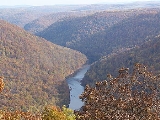
Main overlook
The forest is best known for its scenic overlooks of the Cheat River in Cheat CanyonCheat Canyon
Cheat Canyon — also called Cheat River Canyon or Cheat River Gorge — is a 10-mile long, forested canyon of the Cheat River at the western edge of the Allegheny Mountains in northeastern West Virginia, USA...
. The main overlook is accessible by car and was developed as a CCC project. It provides excellent views of the Cheat
Cheat River
The Cheat River is a tributary of the Monongahela River in eastern West Virginia and southwestern Pennsylvania in the United States. Via the Monongahela and Ohio rivers, it is part of the Mississippi River watershed, ultimately draining into the Gulf of Mexico.-Geography:The Cheat is formed at...
, Snake Hill Wildlife Management Area
Snake Hill Wildlife Management Area
The Snake Hill Wildlife Management Area is a hilly area covering along the Cheat River canyon in Monongalia and Preston Counties, West Virginia...
across the river, and Morgantown
Morgantown, West Virginia
Morgantown is a city in Monongalia County, West Virginia. It is the county seat of Monongalia County. Placed along the banks of the Monongahela River, Morgantown is the largest city in North-Central West Virginia, and the base of the Morgantown metropolitan area...
to the west. The overlook is located on a large rock connected to the main land by a footbridge. It is not handicapped-accessible, but there is a nearby ADA-compliant overlook.
Raven Rock overlook
For a more rustic view, many people take the approximately 2 miles (3.2 km) hike to Raven Rock. This site, which is dominated by a high-voltage power line crossing of the Cheat RiverCheat River
The Cheat River is a tributary of the Monongahela River in eastern West Virginia and southwestern Pennsylvania in the United States. Via the Monongahela and Ohio rivers, it is part of the Mississippi River watershed, ultimately draining into the Gulf of Mexico.-Geography:The Cheat is formed at...
, is home to a series of large boulders and features a point that juts into the canyon. Hikers to this site with pets and children should be cautious as there are no railings - missteps could lead to significant and potentially fatal falls.
Hiking
Coopers Rock is home to a well-developed system of nearly 50 miles (80.5 km) of hiking trails. These trails are generally usable for cross-country skiing during the winter.One trail, approximately 3 miles (4.8 km) long, provides access to the former Mont Chateau State Park
Mont Chateau State Park
Mont Chateau State Park was formerly a state park located beside Cheat Lake in Monongalia County, West Virginia, USA.-Commissioning and operations:...
at Cheat Lake
Cheat Lake
Cheat Lake is a long reservoir on the Cheat River in Monongalia County, West Virginia, USA. It was originally named Lake Lynn, but the Board on Geographic Names officially decided upon Cheat Lake as the reservoir's name in 1976. The surface area of Cheat Lake is about...
.
The Rock City Trail leads through rock city, a long crevasse between towering outcrops.
Rock Climbing
Cooper's Rock is a popular boulderingBouldering
Bouldering is a style of rock climbing undertaken without a rope and normally limited to very short climbs over a crash pad so that a fall will not result in serious injury. It is typically practiced on large natural boulders or artificial boulders in gyms and outdoor urban areas...
area with boulder problems ranging from V0-V11 and numerous areas that can be easily set up for top-roping. Bolting is currently prohibited.
Campground
There is a 25-lot campground at Coopers Rock open April 1-November 30. All lots have electric hookups and there is a showerhouse in the campground.Henry Clay Iron Furnace
Aside from the overlooks, the Henry Clay Iron Furnace is perhaps the most well-known portion of the forest. Accessible via the Clay Furnace or Clay Run trails, the furnace was built between 1834-1836 and produced pig ironPig iron
Pig iron is the intermediate product of smelting iron ore with a high-carbon fuel such as coke, usually with limestone as a flux. Charcoal and anthracite have also been used as fuel...
. Capable of producing 4 tons of iron each day, the furnace employed about 200 people and operated until 1847.
It was listed on the National Register of Historic Places
National Register of Historic Places
The National Register of Historic Places is the United States government's official list of districts, sites, buildings, structures, and objects deemed worthy of preservation...
in 1970.
See also
- Cheat RiverCheat RiverThe Cheat River is a tributary of the Monongahela River in eastern West Virginia and southwestern Pennsylvania in the United States. Via the Monongahela and Ohio rivers, it is part of the Mississippi River watershed, ultimately draining into the Gulf of Mexico.-Geography:The Cheat is formed at...
- Cheat LakeCheat LakeCheat Lake is a long reservoir on the Cheat River in Monongalia County, West Virginia, USA. It was originally named Lake Lynn, but the Board on Geographic Names officially decided upon Cheat Lake as the reservoir's name in 1976. The surface area of Cheat Lake is about...
- Mont Chateau State ParkMont Chateau State ParkMont Chateau State Park was formerly a state park located beside Cheat Lake in Monongalia County, West Virginia, USA.-Commissioning and operations:...
, a former state park adjoining the forest - Cooper's Rock State Forest Superintendent's House and GarageCooper's Rock State Forest Superintendent's House and GarageCooper's Rock State Forest Superintendent's House and Garage is a historic home and garage located at Cooper's Rock State Forest near Morgantown, Monongalia County, West Virginia. The house was built between 1938 and 1940, and is a two-story, symmetrical log building, measuring 35 feet by 43 feet....