
Combahee River
Encyclopedia
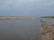
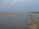
Blackwater river
A blackwater river is a river with a deep, slow-moving channel that flows through forested swamps and wetlands. As vegetation decays in the water, tannins are leached out, resulting in transparent, acidic water that is darkly stained, resembling tea or coffee. Most major blackwater rivers are in...
in the southern Lowcountry region of South Carolina
South Carolina
South Carolina is a state in the Deep South of the United States that borders Georgia to the south, North Carolina to the north, and the Atlantic Ocean to the east. Originally part of the Province of Carolina, the Province of South Carolina was one of the 13 colonies that declared independence...
formed at the confluence of the Salkehatchie
Salkehatchie River
The Salkehatchie River originates near the City of Barnwell, South Carolina and accepts drainage from Turkey Creek and Whippy Swamp before merging with the Little Salkehatchie River to form the Combahee River Basin, which empties into Saint Helena Sound and the Atlantic Ocean...
and Little Salkehatchie
Little Salkehatchie River
The Little Salkehatchie River originates in the Town of Blackville, South Carolina and accepts drainage fromLake Cynthia, Guess Pond, Brooker Pond, Ghants Branch, Halfmoon Branch, and Long Gall Branch....
rivers near the Islandton community of Colleton County, South Carolina. Part of its lower drainage basin
Drainage basin
A drainage basin is an extent or an area of land where surface water from rain and melting snow or ice converges to a single point, usually the exit of the basin, where the waters join another waterbody, such as a river, lake, reservoir, estuary, wetland, sea, or ocean...
combines with the Ashepoo River
Ashepoo River
Ashepoo River is a short blackwater river in South Carolina. It rises in a confluence of swamps south of Walterboro, flows in southeast direction and then empties into Saint Helena Sound at . The entire course of the river lies within the boundaries of Colleton County...
and the Edisto River
Edisto River
The Edisto River is the longest completely undammed / unleveed blackwater river in North America, flowing 206 meandering miles from its sources in Saluda and Edgefield counties, to its Atlantic Ocean mouth at Edisto Beach, SC...
to form the ACE Basin
ACE Basin
The ACE Basin is one of the largest undeveloped estuaries along the Atlantic Coast of the United States. Located primarily in Colleton and Beaufort counties in South Carolina, the ACE Basin is an acronym that represents the Ashepoo, Combahee and Edisto rivers, which combine into the larger St....
The Combahee empties into Saint Helena Sound
Saint Helena Sound
Saint Helena Sound is a coastal inlet in Beaufort and Colleton counties, South Carolina. The inlet is located East of Beaufort, between Edisto Island. and Hunting Island. Saint Helena Sound is 7.5 mi/12.1 km wide. The Combahee River empties from the Northwest and the Edisto River and...
near Beaufort
Beaufort, South Carolina
Beaufort is a city in and the county seat of Beaufort County, South Carolina, United States. Chartered in 1711, it is the second-oldest city in South Carolina, behind Charleston. The city's population was 12,361 in the 2010 census. It is located in the Hilton Head Island-Beaufort Micropolitan...
, which in turn empties into the Atlantic Ocean
Atlantic Ocean
The Atlantic Ocean is the second-largest of the world's oceanic divisions. With a total area of about , it covers approximately 20% of the Earth's surface and about 26% of its water surface area...
.
History
The Combahee River was made famous as the location of the Harriet TubmanHarriet Tubman
Harriet Tubman Harriet Tubman Harriet Tubman (born Araminta Harriet Ross; (1820 – 1913) was an African-American abolitionist, humanitarian, and Union spy during the American Civil War. After escaping from slavery, into which she was born, she made thirteen missions to rescue more than 70 slaves...
Combahee River Raid
Raid at Combahee Ferry
The Raid at Combahee Ferry was a military operation during the American Civil War; it was conducted on June 1 and June 2, 1863, by elements of the Union Army along the Combahee River in Beaufort and Colleton counties in southeast South Carolina.-Background:...
, a Union raid into the interior of South Carolina June 2, 1863 which freed over 750 slaves. The bridge across the Combahee on US Highway 17 is the location today.
The Combahee River bordered and supplied the water for some of the largest, most productive rice plantations prior to the Civil War. It was also the scene of skirmishes during the Yamasee War
Yamasee
The Yamasee were a multiethnic confederation of Native Americans that lived in the coastal region of present-day northern coastal Georgia near the Savannah River and later in northeastern Florida.-History:...
and the Revolutionary War. It was during the Revolutionary War that the British made an attempt at foraging which the Americans headed by General Gist and Colonel John Laurens
John Laurens
John Laurens was an American soldier and statesman from South Carolina during the Revolutionary War. He gained approval by the Continental Congress in 1779 to recruit a regiment of 3000 slaves by promising them freedom in return for fighting...
opposed, causing the loss of John Laurens' life.
The Combahee area was first settled in the 1680s. Before the Yamasee War of 1715, land was set aside for the Yamasee
Yamasee
The Yamasee were a multiethnic confederation of Native Americans that lived in the coastal region of present-day northern coastal Georgia near the Savannah River and later in northeastern Florida.-History:...
along several rivers including the Combahee.