
.gif)
Columbus Drive (Chicago)
Encyclopedia
.jpg)
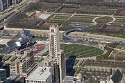
Grant Park (Chicago)
Grant Park, with between the downtown Chicago Loop and Lake Michigan, offers many different attractions in its large open space. The park is generally flat. It is also crossed by large boulevards and even a bed of sunken railroad tracks...
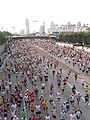
. It is 254 E in Chicago's street numbering system. Its south end is an interchange with Lake Shore Drive
Lake Shore Drive
Lake Shore Drive is a mostly freeway-standard expressway running parallel with and alongside the shoreline of Lake Michigan through Chicago, Illinois, USA. Except for the portion north of Foster Avenue , Lake Shore Drive is designated as part of U.S...
(US 41) at Soldier Field
Soldier Field
Soldier Field is located on Lake Shore Drive in Chicago, Illinois, United States, in the Near South Side. It is home to the NFL's Chicago Bears...
. North of Illinois Street it becomes Fairbanks Court and continues north ending at Chicago Avenue.
Roadway
In the Illinois CenterIllinois Center
Illinois Center is a mixed-use urban development in downtown Chicago, Illinois, USA, lying east of Michigan Avenue. It is notable in that the streets running through it have three levels. Elsewhere in Chicago, some streets have two levels, with the lower level for through traffic and service...
development, the main lanes of Columbus are on the middle level of a three-level structure. That level intersects with the middle levels of Randolph Street
Randolph Street (Chicago)
Randolph Street is a street in Chicago. It runs east-west through the Chicago Loop, carrying westbound traffic west from Michigan Avenue across the Chicago River on the Randolph Street Bridge, interchanging with the Kennedy Expressway , and continuing west. It serves as the northern boundary of...
, Lake Street
Lake Street (Chicago)
Lake Street is an east-west arterial road in Chicago and its suburbs. Part of Lake Street is designated as U.S. Route 20. Lake Street begins in the city of Chicago and travels west and slightly north to the Chicago suburbs. It ends at the eastern terminus of the Elgin Bypass around Elgin, where...
, South Water Street and Wacker Drive. All these streets also exist on the lower and upper levels, except for Lake, which is a pedestrian mall
Pedestrian mall
Pedestrian malls in the United States are also known as pedestrian streets and are the most common form of pedestrian zone in large cities in the United States. It is a street lined with storefronts and closed off to most automobile traffic...
on the upper level; both of these levels go only from Randolph to Wacker. Ramps are connected directly to Columbus at the following points:
- Southbound downramp and northbound upramp between the lower and middle levels, between Randolph and Lake; no access from the upramp to Lake
- Westbound downramp and eastbound upramp in the middle of South Water between the lower and middle levels, just west of Columbus
- Westbound upramp from the service (lowest) level at Wacker to middle Wacker west of Stetson Avenue (which quickly goes back down to become lower Wacker)
Columbus Drive crosses the Chicago River
Chicago River
The Chicago River is a system of rivers and canals with a combined length of that runs through the city of the same name, including its center . Though not especially long, the river is notable for being the reason why Chicago became an important location, as the link between the Great Lakes and...
on the Columbus Avenue Bridge, a bascule bridge
Bascule bridge
A bascule bridge is a moveable bridge with a counterweight that continuously balances the span, or "leaf," throughout the entire upward swing in providing clearance for boat traffic....
. North of the river, it crosses the upper level of North Water Street and passes over the lower level before going down to ground level at Illinois Street.
History
Columbus originally only went south from Monroe Street, south of Illinois Center. In 1980, it was extended to Wacker, including the three-level portion, and it was built over the Chicago RiverChicago River
The Chicago River is a system of rivers and canals with a combined length of that runs through the city of the same name, including its center . Though not especially long, the river is notable for being the reason why Chicago became an important location, as the link between the Great Lakes and...
in 1982, connecting to Fairbanks Court. In 1992 the upper level of North Water was built.
See also
- Multilevel streets in ChicagoMultilevel streets in ChicagoDowntown Chicago, Illinois has some double-decked and a few triple-decked streets immediately north and south of the Main Branch and immediately east of the South Branch of the Chicago River. The most famous and longest of these is Wacker Drive, which replaced the South Water Street Market upon its...