

Columbia Trail
Encyclopedia
The Columbia Trail is a rail trail
in rural northwestern New Jersey
. It was created from portions of the former Central Railroad of New Jersey
High Bridge Branch
and stretches from High Bridge
, in Hunterdon County
, to Flanders
, in Morris County
for a total of 16.2 miles (26.1 km). The trail surface is relatively flat and consists mostly of fine crushed stone.
. In 1976, the branch was deemed redundant by its new owner, Conrail, and the rails were dismantled in 1980. Since then, it has been a recreational trail serving the surrounding communities. In the mid-1990s, Columbia Gas Company bought the trail right-of-way and laid an underground gas
pipeline under the right-of-way
along the length of the trail. The trail and bridges were resurfaced in 2004. The Hunterdon County Department of Parks and Recreation and Morris County Department of Parks and Recreation now operate and maintain the trail under lease, although ownership of the right-of-way remains with the Columbia Gas Company. Lewis H Taylor a member of the trustees of the Central Jersey Railroad brought the railroad in to High Bridge originally to bring coal to fuel the Taylor Wharton Iron and Steel Company , the oldest foundry in United States History.
This connects to the Taylor Steelworkers Historic Greenway.
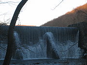
The Columbia Trail owes its name to a train wreck that occurred on the trestle on April 18, 1885, when an iron ore train led by the Columbia Engine derailed and crashed on the trestle and into the river below. IRON MINE RAILROAD OF NORTHERN NEW JERSEY, by Larry Lowenthal, indicates this was engine 112 and does not indicate it had a name. The trail is, instead, most likely named for the Columbia Gas Pipeline.
parallels the trail along most of its route through the county. Near the northern terminus of the trail in Morris County is Long Valley, New Jersey
, where the trail crosses a road near a small commercial district. Just north of Long Valley, Patriots' Path
provides links east towards County Route 513
and west towards Schooley's Mountain Park.
Beyond the northern end of the trail at Flanders, an active rail line is still in service and operated by the Morristown and Erie Railway
to Wharton
. The trail connects to the New Jersey Transit
Raritan Valley Line
at High Bridge and connects to Patriots Path in Long Valley
.
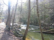
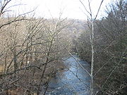 A notable portion of the Columbia Trail is the Ken Lockwood Gorge
, between Califon
and High Bridge
(2½ miles north of High Bridge). The South Branch of the Raritan River
parallels the trail through the gorge, and is a scenic fast-flowing small river
with recreational activities, especially fly fishing
. A 60 feet (18.3 m) trestle
carries the trail over the river in the gorge.
 There are few remnants of the former rail line along the trail, except for the occasional rotting railroad cross ties along the trail. There is a small section of track preserved in Califon and a small and rarely open museum dedicated to the rail line history is located in the preserved train station in the town center.
The Long Valley
trailhead is located on County Route 517
(Schooleys Mountain Road) between West Maple and Fairview Avenues and offers a public parking area.
A brochure with a map of the Patriot Path trail indicates that the Columbia trail may continue north beyond Long Valley for another 4 to 5 miles where it terminates at Bartley road, this section however can not be verified from satellite images on Google Earth.
Rail trail
A rail trail is the conversion of a disused railway easement into a multi-use path, typically for walking, cycling and sometimes horse riding. The characteristics of former tracks—flat, long, frequently running through historical areas—are appealing for various development. The term sometimes also...
in rural northwestern New Jersey
New Jersey
New Jersey is a state in the Northeastern and Middle Atlantic regions of the United States. , its population was 8,791,894. It is bordered on the north and east by the state of New York, on the southeast and south by the Atlantic Ocean, on the west by Pennsylvania and on the southwest by Delaware...
. It was created from portions of the former Central Railroad of New Jersey
Central Railroad of New Jersey
The Central Railroad of New Jersey , commonly known as the Jersey Central Lines or CNJ, was a Class I railroad with origins in the 1830s, lasting until 1976 when it was absorbed into Conrail with the other bankrupt railroads of the Northeastern United States...
High Bridge Branch
High Bridge Branch
The High Bridge Branch was a branch line of the Central Railroad of New Jersey that started in High Bridge, New Jersey at a connection with the CNJ main line and continued north to iron-ore mines in Morris County...
and stretches from High Bridge
High Bridge, New Jersey
High Bridge is a borough in Hunterdon County, New Jersey, United States. As of the United States 2010 Census, the borough population was 3,648.-History:...
, in Hunterdon County
Hunterdon County, New Jersey
Hunterdon County is a county located in the western section of the U.S. state of New Jersey. As of the 2010 United States Census, the population was 128,349. It is part of the New York Metropolitan Area. Its county seat is Flemington....
, to Flanders
Flanders, New Jersey
Flanders is an unincorporated area located in Mount Olive Township and parts of Roxbury Township, in southwest Morris County, New Jersey, United States. Flanders is served by the United States Postal Service as ZIP Code 07836....
, in Morris County
Morris County, New Jersey
Morris County is a county located in the U.S. state of New Jersey, about west of New York City. According to the United States 2010 Census, the population was 492,276. It is part of the New York Metropolitan Area. Its county seat is Morristown....
for a total of 16.2 miles (26.1 km). The trail surface is relatively flat and consists mostly of fine crushed stone.
History
Built in 1876, the railroad branch line was used for passenger and freight traffic. The type of freight most commonly moved was iron ore from mines in Morris County to be used in the foundries at High Bridge or WhartonWharton, New Jersey
Wharton is a Borough in Morris County, New Jersey, United States. As of the 2000 United States Census, the borough population was 6,298.What is now Wharton was originally incorporated as the borough of Port Oram by an Act of the New Jersey Legislature on June 26, 1895, from portions of Randolph...
. In 1976, the branch was deemed redundant by its new owner, Conrail, and the rails were dismantled in 1980. Since then, it has been a recreational trail serving the surrounding communities. In the mid-1990s, Columbia Gas Company bought the trail right-of-way and laid an underground gas
Natural gas
Natural gas is a naturally occurring gas mixture consisting primarily of methane, typically with 0–20% higher hydrocarbons . It is found associated with other hydrocarbon fuel, in coal beds, as methane clathrates, and is an important fuel source and a major feedstock for fertilizers.Most natural...
pipeline under the right-of-way
Right-of-way (railroad)
A right-of-way is a strip of land that is granted, through an easement or other mechanism, for transportation purposes, such as for a trail, driveway, rail line or highway. A right-of-way is reserved for the purposes of maintenance or expansion of existing services with the right-of-way...
along the length of the trail. The trail and bridges were resurfaced in 2004. The Hunterdon County Department of Parks and Recreation and Morris County Department of Parks and Recreation now operate and maintain the trail under lease, although ownership of the right-of-way remains with the Columbia Gas Company. Lewis H Taylor a member of the trustees of the Central Jersey Railroad brought the railroad in to High Bridge originally to bring coal to fuel the Taylor Wharton Iron and Steel Company , the oldest foundry in United States History.
This connects to the Taylor Steelworkers Historic Greenway.
The Columbia Trail owes its name to a train wreck that occurred on the trestle on April 18, 1885, when an iron ore train led by the Columbia Engine derailed and crashed on the trestle and into the river below. IRON MINE RAILROAD OF NORTHERN NEW JERSEY, by Larry Lowenthal, indicates this was engine 112 and does not indicate it had a name. The trail is, instead, most likely named for the Columbia Gas Pipeline.
Route
The Columbia Trail in Morris County is quite scenic, as the meandering and scenic South Branch of the Raritan RiverSouth Branch Raritan River
The South Branch Raritan River is a tributary of the Raritan River in central New Jersey in the United States.The source of the South Branch is the outflow from Budd Lake, a glacial remnant located a few miles northeast of Hackettstown...
parallels the trail along most of its route through the county. Near the northern terminus of the trail in Morris County is Long Valley, New Jersey
Long Valley, New Jersey
Long Valley is an unincorporated area located within Washington Township, in Morris County, New Jersey. Known as German Valley since its foundation during the colonial era, the community was renamed in response to anti-German sentiment during World War I...
, where the trail crosses a road near a small commercial district. Just north of Long Valley, Patriots' Path
Patriots' Path
The Patriots' Path is a multi-use trail in New Jersey, United States, with a total length of .- References :...
provides links east towards County Route 513
County Route 513 (New Jersey)
County Route 513 is a county highway in the U.S. state of New Jersey. The highway extends from Kingwood Avenue in Frenchtown to Lakeside Road in West Milford...
and west towards Schooley's Mountain Park.
Beyond the northern end of the trail at Flanders, an active rail line is still in service and operated by the Morristown and Erie Railway
Morristown and Erie Railway
The Morristown and Erie Railway is a freight short line railroad based in Morristown, New Jersey. It operates freight rail service five days a week in Morris County, New Jersey and surrounding areas...
to Wharton
Wharton, New Jersey
Wharton is a Borough in Morris County, New Jersey, United States. As of the 2000 United States Census, the borough population was 6,298.What is now Wharton was originally incorporated as the borough of Port Oram by an Act of the New Jersey Legislature on June 26, 1895, from portions of Randolph...
. The trail connects to the New Jersey Transit
New Jersey Transit
The New Jersey Transit Corporation is a statewide public transportation system serving the United States state of New Jersey, and New York, Orange, and Rockland counties in New York State...
Raritan Valley Line
Raritan Valley Line
The Raritan Valley Line is a diesel-engine-powered commuter rail service operated by New Jersey Transit , originating out of Pennsylvania Station, located in Newark, New Jersey, with most trains terminating at the Raritan station, located in Raritan, New Jersey.Some weekday trains continue further...
at High Bridge and connects to Patriots Path in Long Valley
Long Valley, New Jersey
Long Valley is an unincorporated area located within Washington Township, in Morris County, New Jersey. Known as German Valley since its foundation during the colonial era, the community was renamed in response to anti-German sentiment during World War I...
.
Ken Lockwood Gorge
Nestled between Califon and High Bridge in Hunterdon County, New Jersey, is an area with some of New Jersey's most pristine scenery. Combine these with some of the state's hottest trout fishing, hiking, cycling and nature watching, and you have all the necessary elements for an outstanding day.The...
, between Califon
Califon, New Jersey
Califon is a borough in Hunterdon County, New Jersey, United States. As of the 2010 United States Census, the borough population was 1,076.The town was to originally be called California, but was shortened to Califon in order to fit on the welcome sign...
and High Bridge
High Bridge, New Jersey
High Bridge is a borough in Hunterdon County, New Jersey, United States. As of the United States 2010 Census, the borough population was 3,648.-History:...
(2½ miles north of High Bridge). The South Branch of the Raritan River
South Branch Raritan River
The South Branch Raritan River is a tributary of the Raritan River in central New Jersey in the United States.The source of the South Branch is the outflow from Budd Lake, a glacial remnant located a few miles northeast of Hackettstown...
parallels the trail through the gorge, and is a scenic fast-flowing small river
River
A river is a natural watercourse, usually freshwater, flowing towards an ocean, a lake, a sea, or another river. In a few cases, a river simply flows into the ground or dries up completely before reaching another body of water. Small rivers may also be called by several other names, including...
with recreational activities, especially fly fishing
Fly fishing
Fly fishing is an angling method in which an artificial 'fly' is used to catch fish. The fly is cast using a fly rod, reel, and specialized weighted line. Casting a nearly weightless fly or 'lure' requires casting techniques significantly different from other forms of casting...
. A 60 feet (18.3 m) trestle
Trestle
A trestle is a rigid frame used as a support, especially referring to a bridge composed of a number of short spans supported by such frames. In the context of trestle bridges, each supporting frame is generally referred to as a bent...
carries the trail over the river in the gorge.
Trail access
The southern trail head is located in High Bridge, New Jersey, not far from the intersection of Main Street and Van Syckle Place. Although several sources instruct trail users to turn left onto Van Syckle Place to enter the municipal parking lot and access the trail, the municipal lot is actually one block north of Van Syckle on the east side of Main Street and the trail head is directly across Main Street from the parking area.The Long Valley
Long Valley, New Jersey
Long Valley is an unincorporated area located within Washington Township, in Morris County, New Jersey. Known as German Valley since its foundation during the colonial era, the community was renamed in response to anti-German sentiment during World War I...
trailhead is located on County Route 517
County Route 517 (New Jersey)
County Route 517 is a county highway in the U.S. state of New Jersey. The highway extends from Lamington Road in Tewksbury Township to the New York state line in Vernon Township where it continues as Orange County Route 26. It mainly traverses through small, rural communities and unincorporated...
(Schooleys Mountain Road) between West Maple and Fairview Avenues and offers a public parking area.
A brochure with a map of the Patriot Path trail indicates that the Columbia trail may continue north beyond Long Valley for another 4 to 5 miles where it terminates at Bartley road, this section however can not be verified from satellite images on Google Earth.