

Colorado State Highway 82
Encyclopedia
State Highway 82 is an 85.29 mile (137.26 km) long state highway
in the U.S. state
of Colorado
.
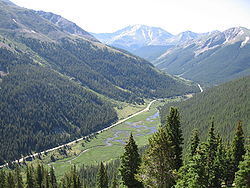 SH 82 provides the principal transportation artery of the Roaring Fork Valley
on the Colorado Western Slope
, running from Interstate 70 at Glenwood Springs
southeast past Carbondale
, Basalt
and Aspen
. Southeast of Aspen it climbs to 12095 ft (3,686.6 m) on a 6% grade at Independence Pass
(open late May–October) before passing through Twin Lakes
and descending to meet U.S. Highway 24 south of Leadville
in the Arkansas River
valley. At its northwestern end it furnishes the principal vehicle access between most of Colorado and the Aspen/Snowmass
resorts. Recently widened to four-lanes along the 50 mile (80 km) section between Glenwood Springs and Aspen, it is heavily used commuting route for day workers between bedroom communities in the lower valley and the resort community of Aspen. In addition to its termini at Interstate 70 and U.S. 24, at Carbondale it intersects State Highway 133
, which furnishes a route over McClure Pass
to the North Fork Valley
near Paonia
. The highway roughly follows the Roaring Fork River
along its entire route, offering scenic views of Mount Sopris
in the lower end of the valley. The Roaring Fork Transit Authority provides well-used public transportation along the highway between Glenwood Springs and Aspen.
!County
!Location
!Mile
!Destination
!Notes
|-
|rowspan=2|Garfield
|Glenwood Springs
|0.00
|
|Interchange
|-
|Carbondale
|11.69
|
|
|-
|Eagle
|colspan=4|No major junctions in Eagle County
|-
|Pitkin
|colspan=4|No major junctionsin Pitkin County
|-
|Lake
|
|85.29
|
|
|-
State highway
State highway, state road or state route can refer to one of three related concepts, two of them related to a state or provincial government in a country that is divided into states or provinces :#A...
in the U.S. state
U.S. state
A U.S. state is any one of the 50 federated states of the United States of America that share sovereignty with the federal government. Because of this shared sovereignty, an American is a citizen both of the federal entity and of his or her state of domicile. Four states use the official title of...
of Colorado
Colorado
Colorado is a U.S. state that encompasses much of the Rocky Mountains as well as the northeastern portion of the Colorado Plateau and the western edge of the Great Plains...
.
Route description
Roaring Fork Valley
The Roaring Fork Valley is a geographical region in western Colorado in the United States. The Roaring Fork Valley is one of the most affluent regions in Colorado as well as one of the most populous and economically vital areas of the Colorado Western Slope. The Valley is defined by the valley of...
on the Colorado Western Slope
Colorado Western Slope
The Western Slope of Colorado refers to a region of the U.S. state of Colorado incorporating everything in the state west of the Continental Divide. The Colorado River and its tributaries divide the region into north and south at Grand Junction, Colorado...
, running from Interstate 70 at Glenwood Springs
Glenwood Springs, Colorado
The City of Glenwood Springs is a Home Rule Municipality that is the county seat and the most populous city of Garfield County, Colorado, United States. The United States Census Bureau estimated that the city population was 8,564 in 2005...
southeast past Carbondale
Carbondale, Colorado
Carbondale is a Home Rule Municipality in Garfield County, Colorado, United States. The population was 5,196 at the 2000 census. The town is located in the mid valley of the Roaring Fork River, downstream from Aspen and upstream from the mouth of the Roaring Fork at Glenwood Springs. The town...
, Basalt
Basalt, Colorado
Basalt is a Statutory Town in Eagle and Pitkin counties in the U.S. state of Colorado. The population was 2,681 at the 2000 census.-Geography:...
and Aspen
Aspen, Colorado
The City of Aspen is a Home Rule Municipality that is the county seat and the most populous city of Pitkin County, Colorado, United States. The United States Census Bureau estimates that the city population was 5,804 in 2005...
. Southeast of Aspen it climbs to 12095 ft (3,686.6 m) on a 6% grade at Independence Pass
Independence Pass (Colorado)
Independence Pass, elevation , is a high mountain pass in the Rocky Mountains of central Colorado in the United States.The pass crosses the ridge of the Sawatch Range between Aspen and Leadville, on the border between Pitkin and Lake counties, and is within the White River National Forest...
(open late May–October) before passing through Twin Lakes
Twin Lakes, Lake County, Colorado
Twin Lakes is a census-designated place and a U.S. Post Office located in Lake County, Colorado, United States. The population as of the 2010 Census was 171...
and descending to meet U.S. Highway 24 south of Leadville
Leadville, Colorado
Leadville is a Statutory City that is the county seat of, and the only municipality in, Lake County, Colorado, United States. Situated at an elevation of , Leadville is the highest incorporated city and the second highest incorporated municipality in the United States...
in the Arkansas River
Arkansas River
The Arkansas River is a major tributary of the Mississippi River. The Arkansas generally flows to the east and southeast as it traverses the U.S. states of Colorado, Kansas, Oklahoma, and Arkansas. The river's initial basin starts in the Western United States in Colorado, specifically the Arkansas...
valley. At its northwestern end it furnishes the principal vehicle access between most of Colorado and the Aspen/Snowmass
Aspen/Snowmass
Aspen/Snowmass is an expansive winter resort complex located in Pitkin County in western Colorado in the United States. Owned and operated by the Aspen Skiing Company it comprises four skiing/snowboarding areas on four adjacent mountains in the vicinity of the towns of Aspen and Snowmass Village...
resorts. Recently widened to four-lanes along the 50 mile (80 km) section between Glenwood Springs and Aspen, it is heavily used commuting route for day workers between bedroom communities in the lower valley and the resort community of Aspen. In addition to its termini at Interstate 70 and U.S. 24, at Carbondale it intersects State Highway 133
Colorado State Highway 133
State Highway 133 is a long north–south byway connecting State Highway 82 to the north and State Highway 92 to the south, and travels through the towns of Hotchkiss, Somerset, Redstone, and Carbondale. Highway 133 travels over a significant mountain pass on the northern end, called McClure Pass,...
, which furnishes a route over McClure Pass
McClure Pass
McClure Pass is a high mountain pass in the Rocky Mountains of western Colorado in the United States.- Overview :...
to the North Fork Valley
North Fork Gunnison River
The North Fork Gunnison River is a tributary of the Gunnison River, long, in southwestern Colorado in the United States. It drains part of the southwestern flank of the Elk Mountains northeast of Delta....
near Paonia
Paonia, Colorado
The Town of Paonia is a Statutory Town in Delta County, Colorado, United States. The population was 1,497 at the 2000 census.-History:The area was first explored in 1853 by Captain John W. Gunnison of the United States Army...
. The highway roughly follows the Roaring Fork River
Roaring Fork River
Roaring Fork River is a tributary of the Colorado River, approximately long, in west central Colorado in the United States. The river drains a populated and economically vital area of the Colorado Western Slope called the Roaring Fork Valley or Roaring Fork Watershed, which includes the resort...
along its entire route, offering scenic views of Mount Sopris
Mount Sopris
Mount Sopris is a high, twin-summitted mountain peak located at the northwest end of the Elk Mountains in western Colorado in the United States. The mountain is located in western Pitkin County, south of Carbondale and southwest of the confluence of the Crystal and Roaring Fork rivers. It lies in...
in the lower end of the valley. The Roaring Fork Transit Authority provides well-used public transportation along the highway between Glenwood Springs and Aspen.
Major intersections
{| class=wikitable!County
!Location
!Mile
!Destination
!Notes
|-
|rowspan=2|Garfield
Garfield County, Colorado
Garfield County is the eighth most extensive and the twelfth most populous of the 64 counties of the State of Colorado of the United States. The county population was 43,791 at U.S. Census 2000. The county is named in honor of United States President James A. Garfield...
|Glenwood Springs
Glenwood Springs, Colorado
The City of Glenwood Springs is a Home Rule Municipality that is the county seat and the most populous city of Garfield County, Colorado, United States. The United States Census Bureau estimated that the city population was 8,564 in 2005...
|0.00
|
|Interchange
|-
|Carbondale
Carbondale, Colorado
Carbondale is a Home Rule Municipality in Garfield County, Colorado, United States. The population was 5,196 at the 2000 census. The town is located in the mid valley of the Roaring Fork River, downstream from Aspen and upstream from the mouth of the Roaring Fork at Glenwood Springs. The town...
|11.69
|
|
|-
|Eagle
Eagle County, Colorado
Eagle County is the thirteenth most populous of the 64 counties of the State of Colorado in the United States. The county is named for the Eagle River. The county population was 41,659 at U.S. Census 2000. The county seat is the Town of Eagle...
|colspan=4|
|-
|Pitkin
Pitkin County, Colorado
Pitkin County is one of the 64 counties of the State of Colorado of the United States. The county is named in honor of the late Colorado Governor Frederick Walker Pitkin. The county population was 14,872 at U.S. Census 2000. The county seat is Aspen...
|colspan=4|
|-
|Lake
Lake County, Colorado
Lake County is one of the 64 counties of the State of Colorado of the United States. The highest natural point in Colorado and the entire Rocky Mountains is the summit of Mount Elbert in Lake County at 14,440 feet elevation. The county population was 7,812 at U.S. Census 2000. The county seat...
|
|85.29
|
|
|-