

Colorado State Highway 74
Encyclopedia
State Highway 74 is an state highway
in the U.S. state of Colorado
. Running 18.11 miles (29.1 km) from Interstate 70
(I-70) to SH 8, the highway forms a rough curve running northwest-southeast. The section of the route north of the town of Evergreen
is known as Evergreen Parkway and is a wider segment than that east of Evergreen. The other section is known as Bear Creek Road and primarily parallels the Bear Creek, passing through the towns of Kittredge
and Idledale
. The route, which is on the outskirts of Denver, passses through several of Denver's mountain parks
, including Bergen Park
, Dedisse Park
and Red Rocks Park
.
An early road following the current path was established in the late 19th century for miners and loggers. As floods ravaged the road along Bear Creek through the early 20th century, measures were taken to prevent damage. Other sites along the Bear Creek, such as a Civilian Conservation Corps
(CCC) camp in Red Rocks Park, make the Bear Creek Canyon Scenic Mountain Drive
, as the section between Idledale and Morrison is called, eligible for the National Register of Historic Places
. An early designation of the route number went further west than its current-day designation; this section was truncated by the late 1930s. Another eastern segment was added from Morrison east toward Denver in the 1940s, but that section too was removed. Newer improvements to the road include widening the Evergreen Parkway segment to four lanes and constructing an interchange with the I-70.
SH 74 then curves eastward and northward as it winds out of town and enters a mountainous area, now known as Bear Creek Road. Narrowing to two lanes, the route follows the path of the Bear Creek, curving northeasterly toward Kittredge with Pence Park on the east side. In Kittredge, the route meets CR 120, Myers Gulch Road, which heads southeast toward Indian Hills
. Where the speed limit is raised to 35 miles per hour (15.6 m/s), the route again meets Kerr Gulch Road, which bypasses the large curve which SH 74 took. From Kittredge, SH 74 winds eastward on the north side of the Bear Creek. The roadway enters Idledale north of the Lair O the Bear Park, where it intersects Grapevine Road. East of the town, an abandoned section of SH 74 exists, which now serves as a path to private areas. The route enters the Bear Creek Canyon Park, where it curves along the creek in a more rocky terrain. SH 74 also passes through Red Rocks Park along the stream. Exiting the park, SH 74 enters Morrison, where Bear Creek Road meets SH 8 at an intersection. From here, SH 8 serves as the continuation of the road as Morrison Road toward Denver.
The route is maintained by the Colorado Department of Transportation
(CDOT), who is responsible for maintaining and constructing transportation infrastructure in Colorado, including highways. As part of this role, CDOT periodically conducts surveys on their highways to measure traffic volume. This is expressed in terms of average annual daily traffic (AADT), which is a measure of traffic volume for any average day of the year. In 2009, CDOT calculated that as few as 3,200 vehicles used SH 74 daily near Idledale, and as many as 23,000 vehicles used SH 74 near the interchange with I-70 as well in Evergreen. No part of the route is listed on the National Highway System
, a system of roads that are important to the nation's economy, defense, and mobility.
, then a former governor of the Territory of Colorado, constructed a toll road from Morrison to Evergreen via the Bear Creek canyon. The early road offered access to various mining and logging resources along the creek. This road had over twenty bridges over the Bear Creek, most of which were made of wood from the surrounding region. By the late 1870s, toll roads became no longer common, and the path became one maintained by Jefferson County, used primarily to access mining camps.
 SH 74 passes through many of Denver's mountain parks, including Bergen Park and Dedisse Park. Established in 1909 by Colorado governor Robert W. Speer
, the system encompassed several areas west of the city, comprising the first city-owned park system in the world. Bear Creek, along which the roadway runs along, was stocked with trout. State Highway 27, as the Bear Creek Canyon Scenic Mountain Drive was designated until 1923, when the number was switched to 74, ran past the Denver Motor Club in Idledale in addition to newly purchased parks. During the 1910s, Denver was granted the ability to enforce laws pertaining to these parks; a speed limit of 20 miles per hour (8.9 m/s) was set along the roadway uphill and 15 miles per hour (6.7 m/s) downhill. In one of the parks, Red Rocks Park near Morrison, a CCC camp was established in 1935 as part of a New Deal
work relief program. The enlistees here built a large amphitheater in the park. Numbered camp SP-13-C, it is the only CCC camp left in the state. Both the camp and the section of SH 74 between Idledale and Morrison, known as the Bear Creek Canyon Scenic Mountain Drive, are listed on the National Register of Historic Places.
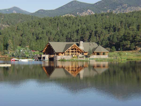
Bear Creek was especially prone to flooding, as was seen in the year 1896 when Morrison, at the eastern terminus of SH 74, was almost destroyed. On occasion, sightseers along the road were threatened by floods, such as one in 1925 where cars on the road were carried into the river. To control flooding along the creek and therefore preserve safety along the road, the Denver manager of parks sought to build a dam near Evergreen. The dam, finished three years after the flood, created Evergreen Lake, may have contributed to increases in tourism in the nearby city with the same name. Following a September 1938 flood, crews from a federal work program built walls along the side of the creek, measuring from 7 feet (2.1 m) to 34 feet (10.4 m) high. The Works Progress Administration (WPA), as this program was called, installed over 4500 feet (1,371.6 m) of masonry from Morrison to Idledale at points where previous floods had damaged the roadway.
 From 1923 through the early 1930s, SH 74's designation was from Echo Lake at what is now an intersection between SH 103
and SH 5 east along Squaw Pass Road to Bergen Park. From here, it followed its current designation to Morrison. SH 74 was paved from Morrison to Evergreen using an oil surface resembling asphalt in late 1928. This oil surface, which was approximately 1 inches (2.5 cm) deep, prevented erosion along the roadway in the Bear Creek canyon during floods. By 1938, the section west of Bergen Park was redesignated as SH 68, and SH 74 was turned northward to US 40. The east end was extended into Denver along Alameda Avenue by 1947. This section terminated at what was then SH 87 in Denver. In 1956, the Colorado State Highway Department opted to realign sections of SH 74 away from Bear Creek. A section of the road between Evergreen and Kittredge was resurfaced and widened the next year. By then, the eastern terminus of the route had been cut back to its original and current ending point in Morrison. Construction on I-70 through the region was completed in 1972 and included an interchange at El Rancho at the northwest end of SH 74. During the 1990s, CDOT sought to further upgrade SH 74 from I-70 to Evergreen to an expressway. Work on this project began in 1993 to improve the interchange between Evergreen Parkway and I-70 and widen the roadway to its current state, costing CDOT $8 million.
.
{| class=wikitable
!Location
!Mile
!Destination
!Notes
|-
|rowspan=2|El Rancho
|0.000
|
|Interchange
|-
|0.374
|
|
|-
|Morrison
|18.110
|
|
|-
State highways in Colorado
The system of State highways in Colorado is a system of public paved roads funded and maintained by the Colorado Department of Transportation; in the U.S. State of Colorado comprises State Highways , U.S. Routes, and Interstate Highways...
in the U.S. state of Colorado
Colorado
Colorado is a U.S. state that encompasses much of the Rocky Mountains as well as the northeastern portion of the Colorado Plateau and the western edge of the Great Plains...
. Running 18.11 miles (29.1 km) from Interstate 70
Interstate 70 in Colorado
Interstate 70 is a transcontinental Interstate Highway in the United States, stretching from Cove Fort, Utah to Baltimore, Maryland. In Colorado, the highway traverses an east–west route across the center of the state. In western Colorado, the highway connects the metropolitan areas of Grand...
(I-70) to SH 8, the highway forms a rough curve running northwest-southeast. The section of the route north of the town of Evergreen
Evergreen, Colorado
Evergreen is a census-designated place and a U.S. Post Office in Jefferson County, Colorado, United States. Evergreen is roughly west of Denver. The population was 9,038 at the 2010 census...
is known as Evergreen Parkway and is a wider segment than that east of Evergreen. The other section is known as Bear Creek Road and primarily parallels the Bear Creek, passing through the towns of Kittredge
Kittredge, Colorado
Kittredge is a census-designated place in Jefferson County, Colorado, United States. The population was 954 at the 2000 census. The Kittredge Post Office has the ZIP Code 80457.-History:Kittredge is the home of former U.S. Senator and U.S...
and Idledale
Idledale, Colorado
Idledale is a census-designated place and a U.S. Post Office in Jefferson County, Colorado, United States. The Idledale Post Office has the ZIP Code 80453.-History:...
. The route, which is on the outskirts of Denver, passses through several of Denver's mountain parks
Denver Mountain Parks
The Denver Mountain Parks system contains more than 14,000 acres of parklands in the mountains and foothills of Jefferson, Clear Creek, Douglas,and Grand counties in Colorado, west and south of Denver....
, including Bergen Park
Bergen Park
Bergen Park is a park near Evergreen, Colorado and is on the National Register of Historic Places.-External links:*...
, Dedisse Park
Dedisse Park
Dedisse Park is a Denver Mountain Park located in Jefferson County, Colorado, USA. It was originally the scenic mountain ranch of 1860s pioneer Julius C. Dedisse; this of land was purchased by the City & County of Denver in 1919...
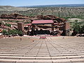
and Red Rocks Park
Red Rocks Park
Red Rocks Park is a mountain park in Jefferson County, Colorado, owned and maintained by the city of Denver as part of the Denver Mountain Parks system. The park is known for its very large red sandstone outcrops. Many of these rock formations within the park have names, from the mushroom-shaped...
.
An early road following the current path was established in the late 19th century for miners and loggers. As floods ravaged the road along Bear Creek through the early 20th century, measures were taken to prevent damage. Other sites along the Bear Creek, such as a Civilian Conservation Corps
Civilian Conservation Corps
The Civilian Conservation Corps was a public work relief program that operated from 1933 to 1942 in the United States for unemployed, unmarried men from relief families, ages 18–25. A part of the New Deal of President Franklin D...
(CCC) camp in Red Rocks Park, make the Bear Creek Canyon Scenic Mountain Drive
Bear Creek Canyon Scenic Mountain Drive
Bear Creek Canyon Scenic Mountain Drive is located mear Morrison, Colorado. It was built in 1914 and added to the National Register of Historic Places on November 15, 1990....
, as the section between Idledale and Morrison is called, eligible for the National Register of Historic Places
National Register of Historic Places
The National Register of Historic Places is the United States government's official list of districts, sites, buildings, structures, and objects deemed worthy of preservation...
. An early designation of the route number went further west than its current-day designation; this section was truncated by the late 1930s. Another eastern segment was added from Morrison east toward Denver in the 1940s, but that section too was removed. Newer improvements to the road include widening the Evergreen Parkway segment to four lanes and constructing an interchange with the I-70.
Route description
Ramps from I-70 westbound branch off the freeway on the north side and cross the highway diagonally southwestward. Access to SH 74 from I-70 eastbound is provided via US 40 a slight distance to the west. From I-70, Evergreen Parkway, as the route is named, heads southeast through El Rancho, meeting an intersection with Swede Gulch Road, numbered as US 40. The route heads westward before turning southeastward into a coniferous forest setting as a four-lane divided highway. The roadway then meets Kerr Gulch Road, designated as County Road 23, near which the speed limit on the highway increases from 40 miles per hour (17.9 m/s) to 50 miles per hour (22.4 m/s). Evergreen Parkway then turns westward and passes Fillius Park to the north in the community of Hidden Valley. The terrain in the region is mountainous. After intersecting Bergen Parkway, which heads southwest toward Bergen Park, SH 74 turns southerly. As the route heads south, Elk Meadow Park appears to the west and a residential area appears to the east. After intersecting Squaw Pass Road and crossing the Troublesome Creek, the east side of the parkway becomes Buchanan Park, where several ponds are located. The west side of SH 74 becomes Elk Meadow Open Space Park, where open grassland is dotted with occasional trees. The road then narrows to two lanes and climbs steeply at milepost fiveas the speed limit drops to 45 miles per hour (20.1 m/s). The speed limit continues to drop gradually all the way to 25 miles per hour (11.2 m/s) at mile eight. While passing Wah Keeney Park, the road turns southeastward and continues to the community of Hiwan Hills. Entering Dedisse Park, Evergreen Parkway enters the town of Evergreen, passing by Evergreen Lake along the Bear Creek. Here, it intersects County Road 74, which heads west along the Upper Bear Creek. The pavement at this point is aged and in a poor condition.SH 74 then curves eastward and northward as it winds out of town and enters a mountainous area, now known as Bear Creek Road. Narrowing to two lanes, the route follows the path of the Bear Creek, curving northeasterly toward Kittredge with Pence Park on the east side. In Kittredge, the route meets CR 120, Myers Gulch Road, which heads southeast toward Indian Hills
Indian Hills, Colorado
Indian Hills is a census-designated place in Jefferson County, Colorado. The population was 1,197 at the 2000 census. The Indian Hills Post Office has the ZIP Code 80454.-Geography:...
. Where the speed limit is raised to 35 miles per hour (15.6 m/s), the route again meets Kerr Gulch Road, which bypasses the large curve which SH 74 took. From Kittredge, SH 74 winds eastward on the north side of the Bear Creek. The roadway enters Idledale north of the Lair O the Bear Park, where it intersects Grapevine Road. East of the town, an abandoned section of SH 74 exists, which now serves as a path to private areas. The route enters the Bear Creek Canyon Park, where it curves along the creek in a more rocky terrain. SH 74 also passes through Red Rocks Park along the stream. Exiting the park, SH 74 enters Morrison, where Bear Creek Road meets SH 8 at an intersection. From here, SH 8 serves as the continuation of the road as Morrison Road toward Denver.
The route is maintained by the Colorado Department of Transportation
Colorado Department of Transportation
The Colorado Department of Transportation is the agency of state government responsible for transportation in the State of Colorado of the United States. CDOT is responsible for maintaining 9,144 mile highway system, including 3,429 bridges with over 28 billion vehicle miles of travel per year...
(CDOT), who is responsible for maintaining and constructing transportation infrastructure in Colorado, including highways. As part of this role, CDOT periodically conducts surveys on their highways to measure traffic volume. This is expressed in terms of average annual daily traffic (AADT), which is a measure of traffic volume for any average day of the year. In 2009, CDOT calculated that as few as 3,200 vehicles used SH 74 daily near Idledale, and as many as 23,000 vehicles used SH 74 near the interchange with I-70 as well in Evergreen. No part of the route is listed on the National Highway System
National Highway System (United States)
The National Highway System is a network of strategic highways within the United States, including the Interstate Highway System and other roads serving major airports, ports, rail or truck terminals, railway stations, pipeline terminals and other strategic transport facilities.Individual states...
, a system of roads that are important to the nation's economy, defense, and mobility.
History
In 1873, John EvansJohn Evans (governor)
John Evans was a U.S. politician, physician, railroad promoter, Governor of the Territory of Colorado, and namesake of Evanston, Illinois; Evans, Colorado; and Mount Evans, Colorado...
, then a former governor of the Territory of Colorado, constructed a toll road from Morrison to Evergreen via the Bear Creek canyon. The early road offered access to various mining and logging resources along the creek. This road had over twenty bridges over the Bear Creek, most of which were made of wood from the surrounding region. By the late 1870s, toll roads became no longer common, and the path became one maintained by Jefferson County, used primarily to access mining camps.
Robert W. Speer
Robert Walter Speer was elected the mayor of Denver, Colorado three times. He served two four-year terms in office from 1904 to 1912. He died from pneumonia in 1918 while halfway through a third term in office that had started in 1916.-Biography:...
, the system encompassed several areas west of the city, comprising the first city-owned park system in the world. Bear Creek, along which the roadway runs along, was stocked with trout. State Highway 27, as the Bear Creek Canyon Scenic Mountain Drive was designated until 1923, when the number was switched to 74, ran past the Denver Motor Club in Idledale in addition to newly purchased parks. During the 1910s, Denver was granted the ability to enforce laws pertaining to these parks; a speed limit of 20 miles per hour (8.9 m/s) was set along the roadway uphill and 15 miles per hour (6.7 m/s) downhill. In one of the parks, Red Rocks Park near Morrison, a CCC camp was established in 1935 as part of a New Deal
New Deal
The New Deal was a series of economic programs implemented in the United States between 1933 and 1936. They were passed by the U.S. Congress during the first term of President Franklin D. Roosevelt. The programs were Roosevelt's responses to the Great Depression, and focused on what historians call...
work relief program. The enlistees here built a large amphitheater in the park. Numbered camp SP-13-C, it is the only CCC camp left in the state. Both the camp and the section of SH 74 between Idledale and Morrison, known as the Bear Creek Canyon Scenic Mountain Drive, are listed on the National Register of Historic Places.
Bear Creek was especially prone to flooding, as was seen in the year 1896 when Morrison, at the eastern terminus of SH 74, was almost destroyed. On occasion, sightseers along the road were threatened by floods, such as one in 1925 where cars on the road were carried into the river. To control flooding along the creek and therefore preserve safety along the road, the Denver manager of parks sought to build a dam near Evergreen. The dam, finished three years after the flood, created Evergreen Lake, may have contributed to increases in tourism in the nearby city with the same name. Following a September 1938 flood, crews from a federal work program built walls along the side of the creek, measuring from 7 feet (2.1 m) to 34 feet (10.4 m) high. The Works Progress Administration (WPA), as this program was called, installed over 4500 feet (1,371.6 m) of masonry from Morrison to Idledale at points where previous floods had damaged the roadway.
Colorado State Highway 103
State Highway 103 in the U.S. state of Colorado runs from I-70 at Idaho Springs to county roads 151 and 103 at Squaw Pass. The thirteen miles from Idaho Springs to State Highway 5 forms about half of the Mount Evans Scenic Byway....
and SH 5 east along Squaw Pass Road to Bergen Park. From here, it followed its current designation to Morrison. SH 74 was paved from Morrison to Evergreen using an oil surface resembling asphalt in late 1928. This oil surface, which was approximately 1 inches (2.5 cm) deep, prevented erosion along the roadway in the Bear Creek canyon during floods. By 1938, the section west of Bergen Park was redesignated as SH 68, and SH 74 was turned northward to US 40. The east end was extended into Denver along Alameda Avenue by 1947. This section terminated at what was then SH 87 in Denver. In 1956, the Colorado State Highway Department opted to realign sections of SH 74 away from Bear Creek. A section of the road between Evergreen and Kittredge was resurfaced and widened the next year. By then, the eastern terminus of the route had been cut back to its original and current ending point in Morrison. Construction on I-70 through the region was completed in 1972 and included an interchange at El Rancho at the northwest end of SH 74. During the 1990s, CDOT sought to further upgrade SH 74 from I-70 to Evergreen to an expressway. Work on this project began in 1993 to improve the interchange between Evergreen Parkway and I-70 and widen the roadway to its current state, costing CDOT $8 million.
Major intersections
The entire route is located in Jefferson CountyJefferson County, Colorado
Jefferson County , whose slogan is the "Gateway to the Rocky Mountains", is the fourth most populous of the 64 counties of the State of Colorado of the United States. Located along the Front Range of the Rocky Mountains, Jefferson County is adjacent to the west side of the state capital, Denver....
.
{| class=wikitable
!Location
!Mile
!Destination
!Notes
|-
|rowspan=2|El Rancho
|0.000
|
|Interchange
|-
|0.374
|
|
|-
|Morrison
Morrison, Colorado
The historic Town of Morrison is a Home Rule Municipality in Jefferson County, Colorado, United States. The population was 430 at the 2000 census...
|18.110
|
|
|-