
Colorado State Highway 62
Encyclopedia
State highway
State highway, state road or state route can refer to one of three related concepts, two of them related to a state or provincial government in a country that is divided into states or provinces :#A...
in the U.S. state
U.S. state
A U.S. state is any one of the 50 federated states of the United States of America that share sovereignty with the federal government. Because of this shared sovereignty, an American is a citizen both of the federal entity and of his or her state of domicile. Four states use the official title of...
of Colorado
Colorado
Colorado is a U.S. state that encompasses much of the Rocky Mountains as well as the northeastern portion of the Colorado Plateau and the western edge of the Great Plains...
.
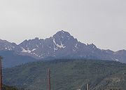
Route description
SH 62 starts at a junction with just north of Ridgeway in the San Miguel RiverSan Miguel River (Colorado)
The San Miguel River is a tributary of the Dolores River, approximately 90 mi long in southwestern Colorado in the United States...
valley and heads northeast up the Leopard Creek Canyon. The highway bends slowly to the east before crossing the Dallas Divide
Dallas Divide
Dallas Divide is a high mountain pass in the United States state of Colorado located on State Highway 62 about west of the town of Ridgway....
at an elevation of 8983 feet (2,738 m). It then follows Cottonwood and Dallas creeks downstream to Ridgeway, Colorado. The highway crosses the Uncompahgre River
Uncompahgre River
The Uncompahgre River is a tributary of the Gunnison River, approximately 75 mi long, in southwestern Colorado in the United States. Lake Como at 12,215 ft in northern San Juan County, in the Uncompahgre National Forest in the northwestern San Juan Mountains is the headwaters of the...
just before ending at a junction with .
State Highway 62 is part of the San Juan Skyway, designated as a National Scenic Byway
National Scenic Byway
A National Scenic Byway is a road recognized by the United States Department of Transportation for its archeological, cultural, historic, natural, recreational, and/or scenic qualities. The program was established by Congress in 1991 to preserve and protect the nation's scenic but often...
in 1996.
Major intersections
{| class=wikitable!County
!Location
!Mile
!Destination
!Notes
|-
|San Miguel
San Miguel County, Colorado
San Miguel County is one of the 64 counties of the state of Colorado of the United States. The county is named for the San Miguel River. The county population was 6,594 at U.S. Census 2000...
|Placerville
Placerville, Colorado
Placerville is an unincorporated town and a U.S. Post Office located in San Miguel County, Colorado, United States. The Placerville Post Office has the ZIP Code 81430.-History:...
|0.000
|
|
|-
|Ouray
Ouray County, Colorado
Ouray County is one of the 64 counties of the State of Colorado in the United States. The county population was 3,742 at U.S. Census 2000. As of 2010, U.S. Census data place the population at 4,436. The county seat is the City of Ouray...
|Ridgway
Ridgway, Colorado
The Town of Ridgway, coined Gateway to the San Juans, is a Home Rule Municipality in Ouray County, in the southwestern portion of the U.S. State of Colorado. The town is a former railroad stop on the Uncompaghre River in the northern San Juan Mountains...
|23.414
|
|