

Cohos Trail
Encyclopedia
Trail
A trail is a path with a rough beaten or dirt/stone surface used for travel. Trails may be for use only by walkers and in some places are the main access route to remote settlements...
running 162 mile through northern New Hampshire
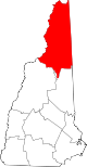
New Hampshire
New Hampshire is a state in the New England region of the northeastern United States of America. The state was named after the southern English county of Hampshire. It is bordered by Massachusetts to the south, Vermont to the west, Maine and the Atlantic Ocean to the east, and the Canadian...
in the United States
United States
The United States of America is a federal constitutional republic comprising fifty states and a federal district...
, connecting the northern and southern ends of Coos County
Coos County, New Hampshire
-National protected areas:*Umbagog National Wildlife Refuge *Silvio O. Conte National Fish and Wildlife Refuge *White Mountain National Forest -Demographics:...
. It begins at Notchland, near Crawford Notch State Park
Crawford Notch State Park
Crawford Notch State Park is located on U.S. Highway 302, in northern New Hampshire, between Bretton Woods and Bartlett. The park occupies the center of Crawford Notch, a major pass through the White Mountains.-External links:*...
, and follows a series of trails to the hamlet
Hamlet (place)
A hamlet is usually a rural settlement which is too small to be considered a village, though sometimes the word is used for a different sort of community. Historically, when a hamlet became large enough to justify building a church, it was then classified as a village...
of Fabyans, then over Cherry Mountain to the town
Town
A town is a human settlement larger than a village but smaller than a city. The size a settlement must be in order to be called a "town" varies considerably in different parts of the world, so that, for example, many American "small towns" seem to British people to be no more than villages, while...
of Jefferson
Jefferson, New Hampshire
Jefferson is a town in Coos County, New Hampshire, United States. The population was 1,107 at the 2010 census. It is home to parts of the White Mountain National Forest in the south and northeast and to two theme parks: Santa's Village and...
, over Mount Waumbek
Mount Waumbek
Mount Waumbek is a mountain located in Coos County, New Hampshire. The mountain is part of the Pliny Range of the White Mountains. Waumbek is flanked to the northeast by Mount Weeks, to the west by Mount Starr King, and to the southeast by Pliny Mountain...
, along the Kilkenny Ridge Trail to Stark
Stark, New Hampshire
Stark is a town in Coos County, New Hampshire, United States. The population was 556 at the 2010 census. It has a famous covered bridge. The town includes the villages of Percy and Crystal as well as the village of Stark, located on the Upper Ammonoosuc River. New Hampshire Route 110 runs through...
, through Nash Stream Forest to Dixville Notch
Dixville Notch, New Hampshire
Dixville Notch is an unincorporated village, with a population of approximately 75, in the Dixville township of Coos County, New Hampshire, USA. The town is known for being one of the first places to declare its results during United States presidential elections and the New Hampshire primary...
, and north to the Connecticut Lakes
Connecticut Lakes
The Connecticut Lakes are a group of lakes in northern New Hampshire, situated along the headwaters of the Connecticut River. They are accessed via the northernmost segment of U.S. Route 3 . The lakes are located within the boundaries of Pittsburg, but are far from the town center...
and finally the Canadian border
Border
Borders define geographic boundaries of political entities or legal jurisdictions, such as governments, sovereign states, federated states and other subnational entities. Some borders—such as a state's internal administrative borders, or inter-state borders within the Schengen Area—are open and...
at the southern edge of Quebec
Quebec
Quebec or is a province in east-central Canada. It is the only Canadian province with a predominantly French-speaking population and the only one whose sole official language is French at the provincial level....
. There it connects with the Sentier Frontalier's trail to Mount Megantic and Mount Gosford
Mount Gosford
Mount Gosford is a mountain located in southern Quebec, Canada at the border with Maine. It lies entirely in Saint-Augustin-de-Woburn in Estrie and is part of the White Mountains of the Appalachians. It is named after Archibald Acheson, 2nd Earl of Gosford, governor general of British North America...
in Canada.
The final section of the trail was completed in 2011, 33 years after it was first proposed by Kim Nilsen, then a newspaper reporter, who became the trail's chief architect.