

Coast to Vines rail trail, South Australia
Encyclopedia
Rail trail
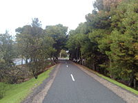
A rail trail is the conversion of a disused railway easement into a multi-use path, typically for walking, cycling and sometimes horse riding. The characteristics of former tracks—flat, long, frequently running through historical areas—are appealing for various development. The term sometimes also...
open to pedestrians and cyclists, runs for 34 km through the southern suburbs of Adelaide
Adelaide
Adelaide is the capital city of South Australia and the fifth-largest city in Australia. Adelaide has an estimated population of more than 1.2 million...
from Marino
Marino, South Australia
Marino is a suburb in the south of Adelaide, South Australia. It sits on coastal hills overlooking Gulf St Vincent, within the City of Marion Local Government Area. It neighbours Seacliff, Hallett Cove and Kingston Park....
to Willunga
Willunga, South Australia
Willunga is a town south of Adelaide, South Australia in the City of Onkaparinga local government area. It is 5 km away from the wine growing region of McLaren Vale and is approx. 47 km from the Adelaide CBD...
. Much of the trail has been constructed on the disused Willunga railway line.
The northern end of the trail begins just south of Marino Rocks railway station, on The Cove Road. From here it follows the Noarlunga Rail line until Hallett Cove station where it shares the footbridge over the line. A short distance away are Hallett Cove shops, where it crosses Lonsdale Highway and proceeds through a picturesque area of Trott Park
Trott Park, South Australia
Trott Park is a suburb in the south of Adelaide, South Australia. It has a population of 2,969 people .It is surrounded in most part by open space: the O'Halloran Hill Recreation Park, and Roseworthy Park, a former CSIRO landhold. It is also bordered by Sheidow Park, Hallett Cove and O'Halloran Hill...
. The right turn into Old South Road at the intersection of Panalatinga Road is easy to miss: it is the start of the section of the trail along the old railway line, with trees lining both sides to Hackham
Hackham, South Australia
Hackham is a metropolitan suburb of Adelaide, South Australia. It lies within the City of Onkaparinga.The Coast to Vines rail trail passes through the suburb.-History:...
. The path is completely off road, but it does cross roads, especially in this area of the trail. The path and the roads are clearly signposted. The path crosses Christies Creek and a number of other small creeks along this section. Continuing on will take the rider to the Onkaparinga River
Onkaparinga River
The Onkaparinga River runs from its source between Mount Torrens and Charleston in the Mount Lofty Ranges, and flows south westerly to an estuary at Port Noarlunga. The catchment is over 500 km² in area, and is in part located in the Onkaparinga River National Park.The Onkaparinga River is the...
and from there to McLaren Vale
McLaren Vale
McLaren Vale is a wine region approximately 35 km south of Adelaide in South Australia. It has a population of about 2,000 and is internationally renowned for the wines it produces. The region was named after either David McLaren, the Colonial Manager of the South Australia Company or John...
and Willunga
Willunga, South Australia
Willunga is a town south of Adelaide, South Australia in the City of Onkaparinga local government area. It is 5 km away from the wine growing region of McLaren Vale and is approx. 47 km from the Adelaide CBD...
.
The trail is an easy ride and suitable for beginners, families and more experienced riders.
The former railway line stations were Happy Valley
Happy Valley, South Australia
Happy Valley is a metropolitan suburb of Adelaide, South Australia. It is located 20 km south of the Central Business District of Adelaide.Within the suburb is the Happy Valley Reservoir accompanied by South Australia's largest water treatment plant, responsible for supplying water to much of the...
, Reynella
Reynella, South Australia
Reynella is a metropolitan suburb of Adelaide, South Australia.It is located 20km south of the Central Business District of Adelaide in the north of the City of Onkaparinga...
, Coorara, Morphett Vale
Morphett Vale, South Australia
Morphett Vale is a southern suburb of Adelaide, South Australia in the City of Onkaparinga. It is the largest suburb in the state, with a population of more than 23,000 and an area of 12.76km², followed by Paralowie with nearly 10,000 fewer residents. There are approximately 1,000 businesses in...
, Yetto, Hackham
Hackham, South Australia
Hackham is a metropolitan suburb of Adelaide, South Australia. It lies within the City of Onkaparinga.The Coast to Vines rail trail passes through the suburb.-History:...
, Korro, Noarlunga, Moana
Moana, South Australia
Moana is a coastal suburb in the south of Adelaide, South Australia.It lies within the City of Onkaparinga local government area, and neighbours the suburbs Seaford, Maslin Beach, and Seaford Rise.-Beach front:...
, Tuni, McLaren Vale
McLaren Vale, South Australia
McLaren Vale is a township in the wine region of McLaren Vale in South Australia. At the 2006 census, McLaren Vale had a population of 2,908....
, Pickkard, Taringa and Willunga
Willunga, South Australia
Willunga is a town south of Adelaide, South Australia in the City of Onkaparinga local government area. It is 5 km away from the wine growing region of McLaren Vale and is approx. 47 km from the Adelaide CBD...
.
The trail is mostly complete, with a small section along the main street of Mclaren Vale yet to be finished.. It intersects with the Adelaide Southern Veloway
Adelaide Southern Veloway
thumb|right|230px|The Southern Veloway near its start south of the Seacombe Road bridge, at Marion.thumb|right|230px|The Southern Veloway south of the Glenthorne Path bridge, at O'Halloran Hill....
at both Panalatinga Road turnoff and Southern end of the Southern Expressway
Southern Expressway
The Southern Expressway is the world's longest reversible one way freeway. Originally proposed as 'Noarlunga Freeway', it was built as a corridor to relieve heavy traffic from the major arterial, Main South Road, in Adelaide's south. The expressway was built in two stages — the first...
.