

Claire Allen
Encyclopedia
]
 ]
]
 ]
]
Claire Allen was a prominent southern Michigan architect of the early twentieth century. He was head of the firm of Claire Allen & Sons and had practiced architecture in Jackson for 52 years.
When Allen was younger he was a contractor and builder, working on such things as the Ionia County
Court House, a school in Dexter, Michigan
, and many houses and buildings in Belding and Ionia, as well as the Belding Brothers silk Mills. Some of the county courthouses Allen created are great examples of the American neoclassical architecture
style. He also created many buildings in the colonial revival style.
Books
Web Articles
Claire Allen was a prominent southern Michigan architect of the early twentieth century. He was head of the firm of Claire Allen & Sons and had practiced architecture in Jackson for 52 years.
When Allen was younger he was a contractor and builder, working on such things as the Ionia County
Ionia County, Michigan
-Demographics:As of the census of 2000, there were 61,518 people, 20,606 households, and 15,145 families residing in the county. The population density was 107 people per square mile . There were 22,006 housing units at an average density of 38 per square mile...
Court House, a school in Dexter, Michigan
Dexter, Michigan
Dexter is a village in Washtenaw County in the U.S. state of Michigan. The majority of the village is in the northwest corner of Scio Township with a small portion in Webster Township. The population was 4,067 at the 2010 census...
, and many houses and buildings in Belding and Ionia, as well as the Belding Brothers silk Mills. Some of the county courthouses Allen created are great examples of the American neoclassical architecture
Neoclassical architecture
Neoclassical architecture was an architectural style produced by the neoclassical movement that began in the mid-18th century, manifested both in its details as a reaction against the Rococo style of naturalistic ornament, and in its architectural formulas as an outgrowth of some classicizing...
style. He also created many buildings in the colonial revival style.
Works
Some buildings designed by Allen include:| Work | Image | Place | Year | Historic | Map | Notes |
|---|---|---|---|---|---|---|
| The Post Office | Jackson, Michigan Jackson, Michigan Jackson is a city located along Interstate 94 in the south central area of the U.S. state of Michigan, about west of Ann Arbor and south of Lansing. It is the county seat of Jackson County. As of the 2010 census, the city population was 33,534... |
1932 | Map | Now Consumers Energy's headquarters - Post Office History | ||
| Glazier Office Building | Ann Arbor, Michigan Ann Arbor, Michigan Ann Arbor is a city in the U.S. state of Michigan and the county seat of Washtenaw County. The 2010 census places the population at 113,934, making it the sixth largest city in Michigan. The Ann Arbor Metropolitan Statistical Area had a population of 344,791 as of 2010... |
Map | ||||
| Armory Building | Ann Arbor, Michigan Ann Arbor, Michigan Ann Arbor is a city in the U.S. state of Michigan and the county seat of Washtenaw County. The 2010 census places the population at 113,934, making it the sixth largest city in Michigan. The Ann Arbor Metropolitan Statistical Area had a population of 344,791 as of 2010... |
1911 | Map | |||
| Clock Tower Building | Chelsea, Michigan Chelsea, Michigan Chelsea is a city in Washtenaw County in the U.S. state of Michigan. The population was 4,398 at the 2000 census, at which time it was a village.... |
1907 | State Registered | Map | ||
| Glazier, George P., Memorial Building | 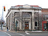 |
Chelsea, Michigan Chelsea, Michigan Chelsea is a city in Washtenaw County in the U.S. state of Michigan. The population was 4,398 at the 2000 census, at which time it was a village.... |
1901-1902 | State Registered | Map | Constructed to house the Chelsea Savings Bank |
| Methodist Episcopal Church | Chelsea, Michigan Chelsea, Michigan Chelsea is a city in Washtenaw County in the U.S. state of Michigan. The population was 4,398 at the 2000 census, at which time it was a village.... |
1899 | Map | First United Methodist Church - Church History | ||
| Welfare Building | Chelsea, Michigan Chelsea, Michigan Chelsea is a city in Washtenaw County in the U.S. state of Michigan. The population was 4,398 at the 2000 census, at which time it was a village.... |
1906 | State Registered | Map | ||
| First National Bank | Corunna, Michigan Corunna, Michigan Corunna is a city in the U.S. state of Michigan. As of the 2000 census, the city population was 3,381. It is the county seat of Shiawassee County. The City of Corunna is located within Caledonia Charter Township, although it is an independent political entity.Michigan Governor Andrew Parsons was... |
1903 | State Registered | Map | Now called the Surbeck Building | |
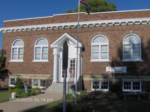
| Hudson Public Library | Hudson, Michigan Hudson, Michigan Hudson is a city in Lenawee County in the U.S. state of Michigan. The population was 2,307 at the 2010 census. The city is located within Hudson Township, but is politically independent.-Geography:... |
Map | ||||
| Cascades Manor House | Jackson, Michigan Jackson, Michigan Jackson is a city located along Interstate 94 in the south central area of the U.S. state of Michigan, about west of Ann Arbor and south of Lansing. It is the county seat of Jackson County. As of the 2010 census, the city population was 33,534... |
1929 | Map | Cascades Manor House History | ||
| Jackson Friendly Home | Jackson, Michigan Jackson, Michigan Jackson is a city located along Interstate 94 in the south central area of the U.S. state of Michigan, about west of Ann Arbor and south of Lansing. It is the county seat of Jackson County. As of the 2010 census, the city population was 33,534... |
1908 | Map | Jackson Friendly Home History | ||
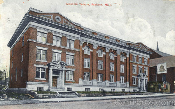
| Jackson Masonic Temple | Jackson, Michigan Jackson, Michigan Jackson is a city located along Interstate 94 in the south central area of the U.S. state of Michigan, about west of Ann Arbor and south of Lansing. It is the county seat of Jackson County. As of the 2010 census, the city population was 33,534... |
1908 | City of Jackson Registered | Map | Currently used by Vermeulens Furniture as show room space - Masonic Temple History | |
| The Ida Stiles Memorial Church | Jackson, Michigan Jackson, Michigan Jackson is a city located along Interstate 94 in the south central area of the U.S. state of Michigan, about west of Ann Arbor and south of Lansing. It is the county seat of Jackson County. As of the 2010 census, the city population was 33,534... |
1895 | The Ida Stiles Memorial Church Article | |||
| Avon School District No. 5 Schoolhouse | Rochester, Michigan Rochester, Michigan Rochester is an affluent city in north Oakland County in the U.S. state of Michigan on the northern outskirts of metro Detroit. The population was 12,711 at the 2010 census... |
1889 | State Registered | Map | ||
| Hillsdale County Courthouse | Hillsdale County, Michigan Hillsdale County, Michigan -Demographics:As of the census of 2000, there were 46,527 people, 17,335 households, and 12,550 families residing in the county. The population density was 78 people per square mile . There were 20,189 housing units at an average density of 34 per square mile... |
1898-1899 | National and State Registered | Map | ||
| Gratiot County Courthouse | Gratiot County, Michigan Gratiot County, Michigan -US Highways:* US-127 routes north to I-75 and south to Lansing.* BUS US-127 is a loop route through downtown Alma.* BUS US-127 is a loop route through downtown Ithaca.* BUS US-127 is a loop route through downtown St. Louis.... |
1902 | National and State Registered | Map | ||
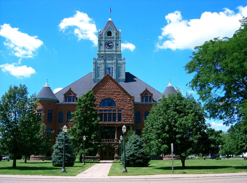
| Ionia County Courthouse | Ionia County, Michigan Ionia County, Michigan -Demographics:As of the census of 2000, there were 61,518 people, 20,606 households, and 15,145 families residing in the county. The population density was 107 people per square mile . There were 22,006 housing units at an average density of 38 per square mile... |
1885 | National and State Registered | Map | Claire Allen was the contractor on this building | |
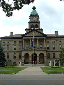
| Jackson County Courthouse | Jackson County, Michigan Jackson County, Michigan As of the census of 2000, there were 158,422 people, 58,168 households, and 40,833 families residing in the county. The population density was 224 people per square mile . There were 62,906 housing units at an average density of 89/sq mi... |
1927-1928 | City of Jackson Registered | Map | Courthouse History | |
| Shiawassee County Courthouse | Shiawassee County, Michigan Shiawassee County, Michigan -Transportation:-Demographics:As of the census of 2000, there were 71,687 people, 26,896 households, and 19,849 families residing in the county. The population density was 133 people per square mile . There were 29,087 housing units at an average density of 54 per square mile... |
1903-1906 | National and State Registered | Map | ||
| Van Buren County Courthouse | |
Van Buren County, Michigan Van Buren County, Michigan -Parks, preserves, natural areas:* Dunes Parkway, an 84 acre preserve of dunes in Covert Township* Jeptha Lake Fen Preserve, a 49 acre preserve in Columbia Township... |
1901 | National and State Registered | Map | |
| Paw Paw Library | Paw Paw, Michigan Paw Paw, Michigan Paw Paw is a village in the U.S. state of Michigan. As of the 2000 census, the village population was 3,363. It is the county seat of Van Buren County.-Overview:... |
1920 | State Registered | Map | ||
| Mendon Township Library | St. Joseph County, Michigan St. Joseph County, Michigan -Demographics:As of the census of 2000, there were 62,422 people, 23,381 households, and 16,600 families residing in the county. The population density was 124 people per square mile . There were 26,503 housing units at an average density of 53 per square mile... |
1905 | State Registered | Map | ||
| Berthold Rummler House | Jackson, Michigan Jackson, Michigan Jackson is a city located along Interstate 94 in the south central area of the U.S. state of Michigan, about west of Ann Arbor and south of Lansing. It is the county seat of Jackson County. As of the 2010 census, the city population was 33,534... |
1904 | State Registered | Map | ||
| Lake Odessa Depot | Ionia County, Michigan Ionia County, Michigan -Demographics:As of the census of 2000, there were 61,518 people, 20,606 households, and 15,145 families residing in the county. The population density was 107 people per square mile . There were 22,006 housing units at an average density of 38 per square mile... |
1889 | State Registered | Map | Also known as Detroit, Lansing and Northern Railway Depot | |
| The Rickman Hotel | Kalamazoo, Michigan Kalamazoo, Michigan The area on which the modern city stands was once home to Native Americans of the Hopewell culture, who migrated into the area sometime before the first millennium. Evidence of their early residency remains in the form of a small mound in downtown's Bronson Park. The Hopewell civilization began to... |
1907-1908 | National Registered | Map | ||
| Lee County Savings Bank | |
Fort Madison, Iowa Fort Madison, Iowa Fort Madison, situated on the Mississippi River, is a city in and one of the county seats of Lee County, Iowa, United States. The other county seat is Keokuk. The population was 10,715 at the 2000 census... |
Map | Fort Madison Downtown Commercial Historic District Fort Madison Downtown Commercial Historic District The Fort Madison Downtown Commercial Historic District is a collection of late-19th century store fronts centered on Ave. G, from 6th to 9th Street, and Ave. H from 7th to 9th, in Fort Madison, Iowa. Notable buildings include the Lee County Savings Bank.... |
||
| Clinton County Courthouse |  |
Clinton, Iowa Clinton, Iowa Clinton is a city in and the county seat of Clinton County, Iowa, United States. The population was 26231as of 2010. Clinton, along with DeWitt, Iowa , was named in honor of the seventh governor of New York, DeWitt Clinton. Clinton is the principal city of the Clinton Micropolitan Statistical... |
1892-1897 | Map | History Photo |
Maps
- Claire Allen Buildings in Chelsea, Michigan
- Claire Allen Buildings in Jackson, Michigan
- Claire Allen Buildings in Michigan
- Claire Allen Buildings in Iowa
External links
PhotosBooks
- Buildings in Jackson
- Buildings of Michigan
- Ionia County, Michigan
- Illustrations of a few public and private buildings, the work of Claire Allen, architect.
- Our Hometown: America's History, As Seen Through the Eyes of a Midwestern Village
- Lansing
- Traveling Through Time
- The wondrous works of Claire Allen, architect
Web Articles