

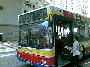
Citybus Route 12
Encyclopedia
Hong Kong Island
Hong Kong Island is an island in the southern part of the Hong Kong Special Administrative Region. It has a population of 1,289,500 and its population density is 16,390/km², as of 2008...
is a circular bus service operated by Citybus
Citybus (Hong Kong)
Citybus Limited is one of the three major bus operators in Hong Kong. It provides both franchised and non-franchised bus service. The franchised route network serves mainly Hong Kong Island, cross-harbour routes , Ocean Park, North Lantau and Hong Kong International Airport...
(CTB), between Central Ferry Piers, Central
Central, Hong Kong
Central is the central business district of Hong Kong. It is located in Central and Western District, on the north shore of Hong Kong Island, across Victoria Harbour from Tsim Sha Tsui, the southernmost point of Kowloon Peninsula...
and Robinson Road
Robinson Road, Hong Kong
Robinson Road is a 2-lane, bi-directional road on the Mid-levels, Hong Kong Island, Hong Kong. In the east, it is connected with the Magazine Gap Road and Garden Road, and in the west with Babington Road and Park Road, Robinson Road is quite long. With Central-Mid-Levels escalator, it also...
, Mid Levels.
History
Route 12 was started by China Motor BusChina Motor Bus
China Motor Bus Company Ltd. , often abbreviated as CMB, was the first motor bus company in Hong Kong, and was responsible for the introduction of double-decker buses to Hong Kong Island....
on 1955-08-16, between the then Central Ferry Pier just adjacent to Connaught Road Central and Seymour Road. It is the first bus route in Hong Kong
Hong Kong
Hong Kong is one of two Special Administrative Regions of the People's Republic of China , the other being Macau. A city-state situated on China's south coast and enclosed by the Pearl River Delta and South China Sea, it is renowned for its expansive skyline and deep natural harbour...
to be designated as a circular route, since there was no room for the construction of a new bus terminal. At that time it ran clockwise in Mid Levels via Robinson Road, Seymour Road and Caine Road
Caine Road
Caine Road is a main road in Hong Kong connecting Bonham Road in the west and Arbuthnot Road and Upper Albert Road in the east ....
. On 1963-05-14 the service was diverted to run on Robinson Road, Park Road
Park Road, Hong Kong
Park Road, is a road in Hong Kong Island, near in between Robinson Road, Hong Kong in Mid-levels and Bonham Road in Sai Ying Pun. Nearby there are some luxury residential buildings including 1 Park Road, Euston Court, Parkway Court, Kingsland Court, Parksdale, Breezy Court....
and Bonham Road
Bonham Road
Bonham Road is a road in Sai Ying Pun, Hong Kong Island in Hong Kong. The road is a main road connecting Pokfulam Road in the west, near the University of Hong Kong, and Caine Road in the east, at the junction with Hospital Road and Seymour Road...
. On 1972-09-11 the Central terminal was changed to a bus terminal opposite to the heaquarters of Hang Seng Bank
Hang Seng Bank
Hang Seng Bank Limited is the second largest bank in Hong Kong. It is a listed company but it is majority owned by the HSBC Group via The Hongkong and Shanghai Banking Corporation. Hang Seng is also one of the constituent shares of the Hang Seng Index...
.
On 1974-04-16 the route was diverted to run anti-clockwise in Mid Levels via Caine Road, Seymour Road and Robinson Road to utilise the newly opened bus lane along westbound Caine and eastbound Robinson, the first in Hong Kong. On 1985-02-01 the terminal was transferred to Connaught Square
Connaught Square
Connaught Square, in the City of Westminster , was the first square of city houses to be built in the Bayswater area. It was named after the Duke of Gloucester , who had a house nearby. The current appearance of the square dates from the 1820s. The square is just north of Hyde Park, and to the west...
and on 1987-04-06 to a permanent bus terminus under Exchange Square
Exchange Square
Exchange Square can refer to:*Exchange Square , South Africa*Exchange Square *Exchange Square , England*Exchange Square , England...
. On 1993-09-01 the route was transferred from CMB to Citybus, together with 25 other routes. Route 12 was designated a full air-conditioned route on the same day.
In 1994 Citybus proposed the merger of routes 12 and 12M, and even issued a passenger notice about it, before the plan was cancelled due to strong opposition from residents in Mid Levels. After the completion of the Central-Mid-Levels escalators
Central-Mid-Levels escalators
The Central–Mid-levels escalators in Hong Kong is the longest outdoor covered escalator system in the world. The entire system covers over 800 metres in distance and elevates over 135 metres from bottom to top...
, the patronage of the route started to decrease. On 1995-09-20 the terminal was changed for the last time to the new Central Piers. In 2003 Citybus again proposed the merger of route 12 with another route, this time with 3B, but was again cancelled due to opposition. Between 2003-04-18 and 2004-08-30 the route passed through Admiralty to deal with the cancellation of M16.
In 2008, Citybus once again proposed that the route be cancelled, citing rising fuel prices and increasing operating costs.
Route
The journey distance is 7.6 km with a time of 37 minutes, via:- Man Kwong Street
- Man Yiu Street
- Harbour View Street
- Connaught Road Central
- Harcourt RoadHarcourt RoadHarcourt Road is a major road in Admiralty in Hong Kong, connecting Wan Chai and Central.-History:Built after World War II, Harcourt Road was once a waterfront promenade and to ease congestion on Hong Kong Island...
- Cotton Tree DriveCotton Tree DriveCotton Tree Drive is a road in Central to Mid-levels on the Hong Kong Island in Hong Kong. The road is famous because of the Cotton Tree Drive Marriage Registry, a hotspot for marriage registration in Hong Kong Park....
- Kennedy RoadKennedy Road, Hong KongKennedy Road is a road in the Mid-levels on the Hong Kong Island, Hong Kong. Starting from Garden Road in the west, it goes past St. Joseph's College, Hong Kong Visual Arts Centre, Hong Kong Park and Hopewell Centre and ends at the junction with Queen's Road East near Morrison Hill in Wan Chai.At...
- Upper Albert RoadUpper Albert RoadUpper Albert Road is a road on Government Hill in the Central District of Hong Kong.Surrounding Government House, the residence of former Governors of Hong Kong and present Chief Executive of Hong Kong, the road is used as a destination for various protests which sometimes results in traffic...
- Caine RoadCaine RoadCaine Road is a main road in Hong Kong connecting Bonham Road in the west and Arbuthnot Road and Upper Albert Road in the east ....
- Seymour Road
- Robinson RoadRobinson RoadRobinson Road is a road which may refer to*Robinson Road in Hong Kong*Robinson Road in Michigan of United States*Robinson Road in Singapore*Former name of Nathan Road in Hong Kong...
- Garden RoadGarden Road, Hong KongGarden Road is a major road on Hong Kong Island, Hong Kong, connecting the Central and Mid-levels areas.At its lower end, Garden Road forms a grade-separated intersection with Queensway. For most of its length, Garden Road carries traffic only in the downhill direction. Uphill traffic is carried...
- Queen's Road Central
- Pedder StreetPedder StreetPedder Street is a major thoroughfare in the core of Hong Kong’s Central District. It runs south-north from Queen's Road Central, continues through Des Voeux Road Central, and ends at its intersection with Connaught Road Central.-History:...
- Connaught SquareConnaught SquareConnaught Square, in the City of Westminster , was the first square of city houses to be built in the Bayswater area. It was named after the Duke of Gloucester , who had a house nearby. The current appearance of the square dates from the 1820s. The square is just north of Hyde Park, and to the west...
- Man Kwong Street