
City of Armadale
Encyclopedia
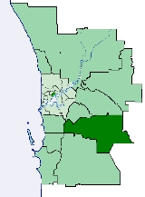
The City of Armadale is a Local Government Area
in the south-eastern suburbs of the Western Australia
n capital city of Perth
, located about 28 kilometres (17.4 mi) southeast of Perth's central business district
. The City covers an area of 560 square kilometres (216 sq mi), much of which is state forest rising into the Darling Scarp
to the east, and has a population of 50,536 as at the 2006 census.
The Kelmscott Road District was created on 14 December 1894 out of parts of Fremantle and Jandakot Road Districts. On 24 March 1910, it was renamed Armadale-Kelmscott.
On 1 July 1961, it became the Shire of Armadale-Kelmscott following the enactment of the Local Government Act 1960. On 1 July 1977, its Byford Ward
was abolished and transferred to the Shire of Serpentine-Jarrahdale.
On 1 July 1979 it became the Town of Armadale and on 16 November 1985 it attained City status.
The City of Armadale maintains 615 km of roads and a little over 14 km² of parks and gardens.
Local Government Areas of Western Australia
The Australian state of Western Australia is divided into 141 local government areas...
in the south-eastern suburbs of the Western Australia
Western Australia
Western Australia is a state of Australia, occupying the entire western third of the Australian continent. It is bounded by the Indian Ocean to the north and west, the Great Australian Bight and Indian Ocean to the south, the Northern Territory to the north-east and South Australia to the south-east...
n capital city of Perth
Perth, Western Australia
Perth is the capital and largest city of the Australian state of Western Australia and the fourth most populous city in Australia. The Perth metropolitan area has an estimated population of almost 1,700,000....
, located about 28 kilometres (17.4 mi) southeast of Perth's central business district
Central business district
A central business district is the commercial and often geographic heart of a city. In North America this part of a city is commonly referred to as "downtown" or "city center"...
. The City covers an area of 560 square kilometres (216 sq mi), much of which is state forest rising into the Darling Scarp
Darling Scarp
The Darling Scarp, also referred to as the Darling Range or Darling Ranges, is a low escarpment running north-south to the east of the Swan Coastal Plain and Perth, Western Australia...
to the east, and has a population of 50,536 as at the 2006 census.
History
Prior to 1894, the area was part of the Canning Road District.The Kelmscott Road District was created on 14 December 1894 out of parts of Fremantle and Jandakot Road Districts. On 24 March 1910, it was renamed Armadale-Kelmscott.
On 1 July 1961, it became the Shire of Armadale-Kelmscott following the enactment of the Local Government Act 1960. On 1 July 1977, its Byford Ward
Byford, Western Australia
Byford is a suburb on the southeastern edge of Perth, Australia, originally founded as the townsite of Beenup in 1906.Beenup took its name from the railway siding there, a corruption of the Aboriginal name of nearby Beenyup Brook...
was abolished and transferred to the Shire of Serpentine-Jarrahdale.
On 1 July 1979 it became the Town of Armadale and on 16 November 1985 it attained City status.
The City of Armadale maintains 615 km of roads and a little over 14 km² of parks and gardens.
Wards
The city has been divided into 7 wards, each with two councillors. The mayor is elected from among the councillors.- Heron Ward
- Lake Ward
- Jarrah Ward
- Minnawarra Ward
- Neerigen Ward
- Palomino Ward
- River Ward
Suburbs
- ArmadaleArmadale, Western AustraliaArmadale is a suburb within the City of Armadale, located on the south-eastern edge of Perth's metropolitan area. The major junction of the South Western and Albany Highways, which connect Perth with the South West and Great Southern regions of Western Australia respectively, is located within the...
- BedfordaleBedfordale, Western AustraliaBedfordale is a semi-rural suburb in the south east of Perth, Western Australia, located within the City of Armadale. Located approximately 40km from Perth in the Darling Range, some of the local attractions include Churchman Brook Dam, Wungong Dam and the Elizabethan Pub. . The area is popular for...
- BrookdaleBrookdale, Western AustraliaBrookdale is a suburb of Perth, Western Australia, located within the City of Armadale. Formerly part of the suburb of Wungong, Brookdale was gazetted in 1997....
- Camillo
- Champion LakesChampion Lakes, Western AustraliaChampion Lakes is a suburb of Perth, Western Australia, located within the City of Armadale.The suburb was originally part of Westfield, but was renamed along with the proposal for a large water-based recreation facility to be constructed in the area....
- ForrestdaleForrestdale, Western AustraliaForrestdale is a suburb of Perth, Western Australia, located within the City of Armadale.- Natural history :Forrestdale is home to Forrestdale Lake, a nature reserve important for waterbirds, many of which breed there. It usually fills in winter and dries out in summer...
- HarrisdaleHarrisdale, Western AustraliaHarrisdale is a southeastern suburb of Perth, Western Australia and is one of the western suburbs of the City of Armadale. It was gazetted in 2007...
- Haynes
- Hilbert
- KarragullenKarragullen, Western AustraliaKarragullen is a suburb of Perth, Western Australia, located within the City of Armadale. Its postcode is 6111.Prior to 1949 it was a stopping place on the Upper Darling Range Railway....
- KelmscottKelmscott, Western AustraliaKelmscott is a southeastern suburb of Perth, Western Australia. Its Local Government Area is the City of Armadale, and it is located southeast of Perth along Albany Highway....
- Mount NasuraMount Nasura, Western AustraliaMount Nasura is a suburb of Perth, Western Australia, located within the City of Armadale. During the 1980s and 1990s, residents successfully campaigned to have the name of the area changed from Armadale to Mount Nasura. Within the suburb is the Armadale-Kelmscott District Memorial Hospital....
- Mount RichonMount Richon, Western AustraliaMount Richon is a suburb of Perth, Western Australia, located within the City of Armadale. Formerly part of Armadale and Wungong, Mount Richon was approved as a suburb in 2003. It is named after a former vineyard in the area....
- Piara Waters
- RoleystoneRoleystone, Western AustraliaRoleystone is an outer southeastern suburb of Perth, Western Australia. Its Local Government Area is the City of Armadale.-History:Roleystone's name originates from a property purchased by Thomas Buckingham in 1858, upon which he built a sawmill in 1866. The town was also referred to as "The...
- Seville GroveSeville Grove, Western AustraliaSeville Grove is a suburb of Perth, Western Australia, located within the City of Armadale.Seville Grove used to be part of Armadale proper but was renamed in 2002....
- WungongWungong, Western AustraliaWungong is a semi-rural south-eastern suburb of Perth, Western Australia, located midway between Armadale and Byford and under the administration of the City of Armadale....
Population
| Year | Population |
|---|---|
| 1911 | 1,327 |
| 1921 | 2,251 |
| 1933 | 3,585 |
| 1947 | 4,253 |
| 1954 | 5,753 |
| 1961 | 6,469 |
| 1966 | 7,840 |
| 1971 | 15,644 |
| 1976 | 25,823 |
| 1981 | 36,116 |
| 1986 | 41,248 |
| 1991 | 46,716 |
| 1996 | 49,507 |
| 2001 | 49,893 |
| 2006 | 50,535 |
- Note: The 1976 figure above, reported from the 1978 year book and 1981 census, is the figure after the removal of 1,634 residents living in ByfordByford, Western AustraliaByford is a suburb on the southeastern edge of Perth, Australia, originally founded as the townsite of Beenup in 1906.Beenup took its name from the railway siding there, a corruption of the Aboriginal name of nearby Beenyup Brook...
and nearby areas, which occurred in 1977.