

Chicopee Falls Dam
Encyclopedia
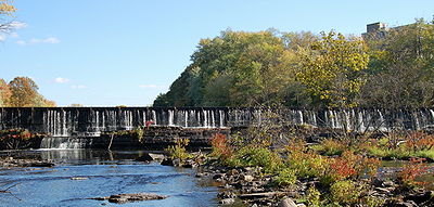
The Chicopee Falls Dam is a masonry stone dam
that parallels Route 33 (Bridge Street) in Chicopee, Massachusetts
. It is part of the Chicopee River Watershed. The dam was constructed in the late 19th century, and is currently owned by the City of Chicopee. It impounds the waters of the Chicopee River
at Chicopee Falls, to form the Chicopee Reservoir.
This is the third to last dam on the Chicopee River before it empties into the Connecticut River
just north of Springfield
.
Flash-boards have been installed to raise the level of the impoundment above the original height of the dam. Therefore, the dam's effective height is greater than the 10 feet (3.05 m) shown in its specifications.
: Just downstream from the Chicopee Falls dam is Dwight Dam, located off Grape St. in Chicopee. The next dam upstream is the Indian Orchard Dam north of Route 141 adjacent to an old mill on Front Street. Putts Bridge Dam at Route 21 between Ludlow
and the Indian Orchard section of Springfield
, the Collins Hydro Dam at Chapin Street between Ludlow and Wilbraham
, and the Red Bridge Dam off East Street between Ludlow and Palmer
. The Putts Bridge Dam was constructed in 1918 as a concrete gravity structure. It rises 22 ft (6.7 m) from the bed of the Chicopee River. The Indian Orchard Dam is a cut stone dam with 28 ft (8.53 m) of height above the river. Each of these dams generate hydroelectric power. The Dwight Dam is cut stone with height of 15 ft.
There is the remnants of the Ames Sword Company Dam, just downstream from Dwight Dam, this is the last dam on the Chicopee River before it empties into the Connecticut. There also used to be a low-head dam just upstream of the Putts Bridge Dam alongside the old Ludlow Mills.
Dam
A dam is a barrier that impounds water or underground streams. Dams generally serve the primary purpose of retaining water, while other structures such as floodgates or levees are used to manage or prevent water flow into specific land regions. Hydropower and pumped-storage hydroelectricity are...
that parallels Route 33 (Bridge Street) in Chicopee, Massachusetts
Chicopee, Massachusetts
Chicopee is a city located on the Connecticut River in Hampden County, Massachusetts, United States of America. It is part of the Springfield, Massachusetts Metropolitan Statistical Area. As of the 2010 census, the city had a total population of 55,298, making it the second largest city in...
. It is part of the Chicopee River Watershed. The dam was constructed in the late 19th century, and is currently owned by the City of Chicopee. It impounds the waters of the Chicopee River
Chicopee River
The Chicopee River is an tributary of the Connecticut River in Metropolitan Springfield, Massachusetts, known for fast-moving water and its extraordinarily large basin: the Connecticut River's largest tributary basin...
at Chicopee Falls, to form the Chicopee Reservoir.
This is the third to last dam on the Chicopee River before it empties into the Connecticut River
Connecticut River
The Connecticut River is the largest and longest river in New England, and also an American Heritage River. It flows roughly south, starting from the Fourth Connecticut Lake in New Hampshire. After flowing through the remaining Connecticut Lakes and Lake Francis, it defines the border between the...
just north of Springfield
Springfield, Massachusetts
Springfield is the most populous city in Western New England, and the seat of Hampden County, Massachusetts, United States. Springfield sits on the eastern bank of the Connecticut River near its confluence with three rivers; the western Westfield River, the eastern Chicopee River, and the eastern...
.
Flash-boards have been installed to raise the level of the impoundment above the original height of the dam. Therefore, the dam's effective height is greater than the 10 feet (3.05 m) shown in its specifications.
Other dams
There are five other dams on this segment of the Chicopee RiverChicopee River
The Chicopee River is an tributary of the Connecticut River in Metropolitan Springfield, Massachusetts, known for fast-moving water and its extraordinarily large basin: the Connecticut River's largest tributary basin...
: Just downstream from the Chicopee Falls dam is Dwight Dam, located off Grape St. in Chicopee. The next dam upstream is the Indian Orchard Dam north of Route 141 adjacent to an old mill on Front Street. Putts Bridge Dam at Route 21 between Ludlow
Ludlow, Massachusetts
Ludlow is a town in Hampden County, Massachusetts, United States. The population was 21,103 as of the 2010 census. It is located in western Massachusetts, north of Springfield, east of Chicopee, southeast of Granby, southwest of Belchertown, west of Wilbraham and is considered part of the...
and the Indian Orchard section of Springfield
Springfield, Massachusetts
Springfield is the most populous city in Western New England, and the seat of Hampden County, Massachusetts, United States. Springfield sits on the eastern bank of the Connecticut River near its confluence with three rivers; the western Westfield River, the eastern Chicopee River, and the eastern...
, the Collins Hydro Dam at Chapin Street between Ludlow and Wilbraham
Wilbraham, Massachusetts
Wilbraham is a town in Hampden County, Massachusetts, United States. It is also a suburb of the City of Springfield, Massachusetts and part of the Springfield Metropolitan Statistical Area. The population was 14,868 at the 2010 census...
, and the Red Bridge Dam off East Street between Ludlow and Palmer
Palmer, Massachusetts
The Town of Palmer is a city in Hampden County, Massachusetts, United States. The population was 12,140 as of the 2000 census. It is part of the Springfield, Massachusetts Metropolitan Statistical Area...
. The Putts Bridge Dam was constructed in 1918 as a concrete gravity structure. It rises 22 ft (6.7 m) from the bed of the Chicopee River. The Indian Orchard Dam is a cut stone dam with 28 ft (8.53 m) of height above the river. Each of these dams generate hydroelectric power. The Dwight Dam is cut stone with height of 15 ft.
There is the remnants of the Ames Sword Company Dam, just downstream from Dwight Dam, this is the last dam on the Chicopee River before it empties into the Connecticut. There also used to be a low-head dam just upstream of the Putts Bridge Dam alongside the old Ludlow Mills.