
Chautauqua County, Kansas
Encyclopedia
Chautauqua County is a county located in Southeast
Kansas
, in the Central
United States
. As of the 2010 census, the county population was 3,669. Its county seat
and most populous city is Sedan
. Chautauqua county is named for Chautauqua County
, New York
.
Chautauqua County was created by an act of the Kansas legislature on June 1, 1875 by the division of Howard County into Elk County
(the northern half) and Chautauqua County (the southern half). At the time of its creation, the county's population was about 7,400.
, county, until 2008' when a county wide ballot measure was approved to allow individual liquor sales with a 30 percent food requirement
 As of the U.S. Census in 2000
, there were 4,359 people, 1,796 households, and 1,235 families residing in the county. The population density
was 7 people per square mile (3/km²). There were 2,169 housing units at an average density of 3 per square mile (1/km²). The racial makeup
of the county was 93.83% White
, 0.30% Black or African American
, 3.58% Native American
, 0.07% Asian
, 0.05% Pacific Islander
, 0.34% from other races, and 1.84% from two or more races
. Hispanic
or Latino
of any race were 1.35% of the population.
There were 1,796 household
s out of which 26.20% had children under the age of 18 living with them, 57.30% were married couples
living together, 7.90% had a female householder with no husband present, and 31.20% were non-families. 29.40% of all households were made up of individuals and 16.40% had someone living alone who was 65 years of age or older. The average household size was 2.34 and the average family size was 2.87.
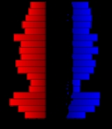
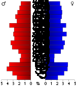
In the county the population was spread out with 23.40% under the age of 18, 6.10% from 18 to 24, 20.90% from 25 to 44, 25.20% from 45 to 64, and 24.30% who were 65 years of age or older. The median age was 45 years. For every 100 females there were 93.60 males. For every 100 females age 18 and over, there were 91.20 males.
The median income for a household
in the county was $28,717, and the median income for a family was $33,871. Males had a median income of $25,083 versus $21,346 for females. The per capita income
for the county was $16,280. About 9.00% of families and 12.20% of the population were below the poverty line, including 15.80% of those under age 18 and 10.60% of those age 65 or over.
. None of the cities within the county are considered governmentally independent, and all figures for the townships include those of the cities. In the following table, the population center is the largest city (or cities) included in that township's population total, if it is of a significant size.
Maps
Southeast Kansas
Southeast Kansas is a region of the U.S. state of Kansas. It can be roughly defined by Woodson County in the northwest, Bourbon County in the northeast, Cherokee County in the southeast, and Montgomery County in the southwest. Geographically it is dominated by a broad rolling landscape located...
Kansas
Kansas
Kansas is a US state located in the Midwestern United States. It is named after the Kansas River which flows through it, which in turn was named after the Kansa Native American tribe, which inhabited the area. The tribe's name is often said to mean "people of the wind" or "people of the south...
, in the Central
Central United States
The Central United States is sometimes conceived as between the Eastern United States and Western United States as part of a three-region model, roughly coincident with the Midwestern United States plus the western and central portions of the Southern United States; the term is also sometimes used...
United States
United States
The United States of America is a federal constitutional republic comprising fifty states and a federal district...
. As of the 2010 census, the county population was 3,669. Its county seat
County seat
A county seat is an administrative center, or seat of government, for a county or civil parish. The term is primarily used in the United States....
and most populous city is Sedan
Sedan, Kansas
Sedan is the county seat of and the largest city in Chautauqua County, Kansas, United States. As of the 2010 census, the city population was 1,124.-Geography:Sedan is located at...
. Chautauqua county is named for Chautauqua County
Chautauqua County, New York
-Major highways:* Interstate 86/New York State Route 17 * Interstate 90 * U.S. Route 20* U.S. Route 62* New York State Route 5* New York State Route 39* New York State Route 60* New York State Route 394...
, New York
New York
New York is a state in the Northeastern region of the United States. It is the nation's third most populous state. New York is bordered by New Jersey and Pennsylvania to the south, and by Connecticut, Massachusetts and Vermont to the east...
.
History
The first white settlers in the area that became Chautauqua County arrived in July 1868.Chautauqua County was created by an act of the Kansas legislature on June 1, 1875 by the division of Howard County into Elk County
Elk County, Kansas
Elk County is a county located in Southeast Kansas, in the Central United States. As of the 2010 census, the county population was 2,882...
(the northern half) and Chautauqua County (the southern half). At the time of its creation, the county's population was about 7,400.
Law and government
Although the Kansas Constitution was amended in 1986 to allow the sale of alcoholic liquor by the individual drink with the approval of voters, Chautauqua County remained a prohibition, or "dry"Dry county
A dry county is a county in the United States whose government forbids the sale of alcoholic beverages. Some prohibit off-premises sale, some prohibit on-premises sale, and some prohibit both. Hundreds of dry counties exist across the United States, almost all of them in the South...
, county, until 2008' when a county wide ballot measure was approved to allow individual liquor sales with a 30 percent food requirement
Geography
According to the 2000 census, the county has a total area of 644.83 square miles (1,670.1 km²), of which 641.69 square miles (1,662 km²) (or 99.51%) is land and 3.14 square miles (8.1 km²) (or 0.49%) is water.Adjacent counties
- Elk CountyElk County, KansasElk County is a county located in Southeast Kansas, in the Central United States. As of the 2010 census, the county population was 2,882...
(north) - Montgomery CountyMontgomery County, KansasMontgomery County is a county located in southeast Kansas, in the Central United States. As of the 2010 census, the county population was 35,471. Its county seat is Independence, and its most populous city is Coffeyville. The Coffeyville Micropolitan Statistical Area includes all of Montgomery...
(east) - Washington CountyWashington County, OklahomaWashington County is a county located in the U.S. state of Oklahoma. It is, in total area, the smallest county in Oklahoma, adjacent to the largest county in Oklahoma, Osage County. It is the second smallest county, by land only size, i.e., not including water. As of 2000, the population was...
, OklahomaOklahomaOklahoma is a state located in the South Central region of the United States of America. With an estimated 3,751,351 residents as of the 2010 census and a land area of 68,667 square miles , Oklahoma is the 28th most populous and 20th-largest state...
(southeast) - Osage CountyOsage County, OklahomaOsage County is a county in the northern part of the U.S. state of Oklahoma. Coterminous with the Osage Indian Reservation, it is the home of the federally recognized Osage Nation. As of the 2010 census, the population was 47,472 a 6.8 percent increase from 2000, when the population was 44,437...
, OklahomaOklahomaOklahoma is a state located in the South Central region of the United States of America. With an estimated 3,751,351 residents as of the 2010 census and a land area of 68,667 square miles , Oklahoma is the 28th most populous and 20th-largest state...
(south) - Cowley CountyCowley County, KansasCowley County is a county located in south-central Kansas, in the Central United States. As of the 2010 census, the county population was 36,311. Its county seat and most populous city is Winfield...
(west)
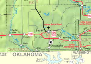
Major highways
Sources: National Atlas, U.S. Census Bureau- U.S. Route 166U.S. Route 166U.S. Route 166 is an east–west United States highway. This route and US-266 are the only two remaining spurs of historic U.S. Highway 66, since US-666 was renumbered in 2003....
- Kansas Highway 38K-38 (Kansas highway)K-38 was a Kansas state highway that started at K-15 north of Dexter in rural Cowley County. It was long, ending in Chautauqua County at an intersection with a county road. There were no towns or state facilities served by the road. K-38 was never completely paved; the last couple of miles of the...
- Kansas Highway 99K-99 (Kansas highway)K-99 is a Kansas state highway that runs north–south through the eastern part of the state.K-99 has its northern terminus near Summerfield at the Nebraska state line and its southern end south of Chautauqua where it crosses the Oklahoma border and becomes State Highway 99...
Demographics
United States Census, 2000
The Twenty-second United States Census, known as Census 2000 and conducted by the Census Bureau, determined the resident population of the United States on April 1, 2000, to be 281,421,906, an increase of 13.2% over the 248,709,873 persons enumerated during the 1990 Census...
, there were 4,359 people, 1,796 households, and 1,235 families residing in the county. The population density
Population density
Population density is a measurement of population per unit area or unit volume. It is frequently applied to living organisms, and particularly to humans...
was 7 people per square mile (3/km²). There were 2,169 housing units at an average density of 3 per square mile (1/km²). The racial makeup
Race (United States Census)
Race and ethnicity in the United States Census, as defined by the Federal Office of Management and Budget and the United States Census Bureau, are self-identification data items in which residents choose the race or races with which they most closely identify, and indicate whether or not they are...
of the county was 93.83% White
White American
White Americans are people of the United States who are considered or consider themselves White. The United States Census Bureau defines White people as those "having origins in any of the original peoples of Europe, the Middle East, or North Africa...
, 0.30% Black or African American
African American
African Americans are citizens or residents of the United States who have at least partial ancestry from any of the native populations of Sub-Saharan Africa and are the direct descendants of enslaved Africans within the boundaries of the present United States...
, 3.58% Native American
Native Americans in the United States
Native Americans in the United States are the indigenous peoples in North America within the boundaries of the present-day continental United States, parts of Alaska, and the island state of Hawaii. They are composed of numerous, distinct tribes, states, and ethnic groups, many of which survive as...
, 0.07% Asian
Asian American
Asian Americans are Americans of Asian descent. The U.S. Census Bureau definition of Asians as "Asian” refers to a person having origins in any of the original peoples of the Far East, Southeast Asia, or the Indian subcontinent, including, for example, Cambodia, China, India, Indonesia, Japan,...
, 0.05% Pacific Islander
Pacific Islander American
Pacific Islander Americans, also known as Oceanian Americans, are residents of the United States with original ancestry from Oceania. They represent the smallest racial group counted in the United States census of 2000. They numbered 874,000 people or 0.3 percent of the United States population...
, 0.34% from other races, and 1.84% from two or more races
Multiracial
The terms multiracial and mixed-race describe people whose ancestries come from multiple races. Unlike the term biracial, which often is only used to refer to having parents or grandparents of two different races, the term multiracial may encompass biracial people but can also include people with...
. Hispanic
Hispanic
Hispanic is a term that originally denoted a relationship to Hispania, which is to say the Iberian Peninsula: Andorra, Gibraltar, Portugal and Spain. During the Modern Era, Hispanic sometimes takes on a more limited meaning, particularly in the United States, where the term means a person of ...
or Latino
Latino
The demonyms Latino and Latina , are defined in English language dictionaries as:* "a person of Latin-American descent."* "A Latin American."* "A person of Hispanic, especially Latin-American, descent, often one living in the United States."...
of any race were 1.35% of the population.
There were 1,796 household
Household
The household is "the basic residential unit in which economic production, consumption, inheritance, child rearing, and shelter are organized and carried out"; [the household] "may or may not be synonymous with family"....
s out of which 26.20% had children under the age of 18 living with them, 57.30% were married couples
Marriage
Marriage is a social union or legal contract between people that creates kinship. It is an institution in which interpersonal relationships, usually intimate and sexual, are acknowledged in a variety of ways, depending on the culture or subculture in which it is found...
living together, 7.90% had a female householder with no husband present, and 31.20% were non-families. 29.40% of all households were made up of individuals and 16.40% had someone living alone who was 65 years of age or older. The average household size was 2.34 and the average family size was 2.87.
In the county the population was spread out with 23.40% under the age of 18, 6.10% from 18 to 24, 20.90% from 25 to 44, 25.20% from 45 to 64, and 24.30% who were 65 years of age or older. The median age was 45 years. For every 100 females there were 93.60 males. For every 100 females age 18 and over, there were 91.20 males.
The median income for a household
Median household income
The median household income is commonly used to generate data about geographic areas and divides households into two equal segments with the first half of households earning less than the median household income and the other half earning more...
in the county was $28,717, and the median income for a family was $33,871. Males had a median income of $25,083 versus $21,346 for females. The per capita income
Per capita income
Per capita income or income per person is a measure of mean income within an economic aggregate, such as a country or city. It is calculated by taking a measure of all sources of income in the aggregate and dividing it by the total population...
for the county was $16,280. About 9.00% of families and 12.20% of the population were below the poverty line, including 15.80% of those under age 18 and 10.60% of those age 65 or over.
Incorporated cities
Name and population ( estimate):- SedanSedan, KansasSedan is the county seat of and the largest city in Chautauqua County, Kansas, United States. As of the 2010 census, the city population was 1,124.-Geography:Sedan is located at...
, (county seat) - Cedar ValeCedar Vale, KansasCedar Vale is a city in Chautauqua County, Kansas, United States. As of the 2010 census, the city population was 579.-Geography:Cedar Vale is located at...
, - PeruPeru, KansasPeru is a city in Chautauqua County, Kansas, United States. As of the 2010 census, the city population was 139.-Geography:Peru is located at . According to the United States Census Bureau, the city has a total area of , all of it land.-Demographics:As of the census of 2000, there were 183...
, - NiotazeNiotaze, KansasNiotaze is a city in Chautauqua County, Kansas, United States. As of the 2010 census, the city population was 82.-Geography:Niotaze is located at . According to the United States Census Bureau, the city has a total area of , all of it land.-Demographics:As of the census of 2000, there were 122...
, - ChautauquaChautauqua, KansasChautauqua is a city in Chautauqua County, Kansas, United States. As of the 2010 census, the city population was 111.-Geography:Chautauqua is located at...
, - ElginElgin, KansasElgin is a city in Chautauqua County, Kansas, United States, on the state line with Oklahoma. As of the 2010 census, the city population was 89.-Geography:Elgin is located at...
,
Unincorporated places
- Cloverdale
- Grafton
- Hale
- HewinsHewins, KansasHewins is a small unincorporated community in Chautauqua County, Kansas, United States. The post office was established April 4, 1906, and closed April 8, 1966. Hewins was named after Edwin M. Hewins, a rancher and member of the Kansas Legislature....
- Jonesburg
- Layton (no longer exists)
- Leeds (no longer exists)
- Lowe (Gibbs)
- Matanzas (no longer exists)
- Monett
- Moore (no longer exists)
- Osro (no longer exists)
- Rogers
- Wauneta
Townships
Chautauqua County is divided into twelve townshipsCivil township
A civil township is a widely used unit of local government in the United States, subordinate to, and geographic divisions of, a county. Specific responsibilities and the degree of autonomy vary based on each state. Civil townships are distinct from survey townships, but in states that have both,...
. None of the cities within the county are considered governmentally independent, and all figures for the townships include those of the cities. In the following table, the population center is the largest city (or cities) included in that township's population total, if it is of a significant size.
| Township | FIPS | Population center |
Population | Population density /km² (/sq mi) |
Land area km² (sq mi) | Water area km² (sq mi) | Water % | Geographic coordinates |
|---|---|---|---|---|---|---|---|---|
| Belleville | 05575 | 675 | 4 (11) | 155 (60) | 0 (0) | 0.14% | 37°3′50"N 96°7′48"W | |
| Caneyville | 10425 | 88 | 1 (2) | 144 (55) | 1 (0) | 0.38% | 37°15′23"N 96°27′27"W | |
| Center | 11575 | 75 | 1 (1) | 144 (56) | 1 (0) | 0.80% | 37°15′28"N 96°18′31"W | |
| Harrison | 30275 | 114 | 1 (2) | 142 (55) | 0 (0) | 0.14% | 37°4′3"N 96°26′32"W | |
| Hendricks | 31300 | 179 | 1 (3) | 142 (55) | 0 (0) | 0.05% | 37°1′12"N 96°18′42"W | |
| Jefferson | 35125 | Cedar Vale Cedar Vale, Kansas Cedar Vale is a city in Chautauqua County, Kansas, United States. As of the 2010 census, the city population was 579.-Geography:Cedar Vale is located at... |
834 | 6 (15) | 144 (56) | 1 (0) | 0.45% | 37°6′45"N 96°29′12"W |
| Lafayette | 37650 | 65 | 0 (1) | 154 (59) | 2 (1) | 1.40% | 37°15′36"N 96°10′20"W | |
| Little Caney | 41525 | 353 | 3 (8) | 117 (45) | 0 (0) | 0.31% | 37°3′51"N 96°1′5"W | |
| Salt Creek | 62775 | 123 | 1 (3) | 127 (49) | 0 (0) | 0.34% | 37°15′13"N 96°1′34"W | |
| Sedan | 63775 | Sedan Sedan, Kansas Sedan is the county seat of and the largest city in Chautauqua County, Kansas, United States. As of the 2010 census, the city population was 1,124.-Geography:Sedan is located at... |
1,660 | 13 (34) | 128 (49) | 1 (0) | 0.65% | 37°7′50"N 96°11′6"W |
| Summit | 69025 | 106 | 1 (2) | 144 (56) | 1 (0) | 0.40% | 37°8′17"N 96°19′53"W | |
| Washington | 75550 | 87 | 1 (2) | 121 (47) | 1 (0) | 0.71% | 37°7′41"N 96°0′52"W | |
| Sources: | ||||||||
Unified school districts
Further reading
- History of the State of Kansas; William G. Cutler; A.T. Andreas Publisher; 1883. (Online HTML eBook)
- Kansas : A Cyclopedia of State History, Embracing Events, Institutions, Industries, Counties, Cities, Towns, Prominent Persons, Etc; 3 Volumes; Frank W. Blackmar; Standard Publishing Co; 944 / 955 / 824 pages; 1912. (Volume1 - Download 54MB PDF eBook),(Volume2 - Download 53MB PDF eBook), (Volume3 - Download 33MB PDF eBook)
External links
CountyMaps
- Chautauqua County Map, KDOT
- Kansas Highway Map, KDOT
- Kansas Railroad Map, KDOT
- Kansas School District Boundary Map, KSDE