

Chama, Zambia
Encyclopedia
Eastern Province, Zambia
Eastern Province is one of Zambia's nine provinces. The province lies between the Luangwa River and the border with Malawi, from Isoka in the northeast to just north of Luangwa in the south.The provincial capital is Chipata...
of Zambia
Zambia
Zambia , officially the Republic of Zambia, is a landlocked country in Southern Africa. The neighbouring countries are the Democratic Republic of the Congo to the north, Tanzania to the north-east, Malawi to the east, Mozambique, Zimbabwe, Botswana and Namibia to the south, and Angola to the west....
, and is headquarters of Chama District
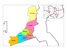
Chama District
Chama District with the headquarters at Chama is the most northerly, largest and least-populated district of the Eastern Province in Zambia and includes a large wilderness in the Upper Luangwa valley just north-east of the North Luangwa National Park...
. It is one of the most remote district headquarters in the country, lying just inside the eastern edge of the upper Luangwa Rift Valley
Luangwa River
The Luangwa River is one of the major tributaries of the Zambezi River, and one of the four biggest rivers of Zambia. The river generally floods in the rainy season and then falls considerably in the dry season...
, at the foot of the highlands dividing Zambia and Malawi. It is served by only one gravel road which comes from Lundazi
Lundazi
Lundazi is a town in eastern Zambia, lying near the border with Malawi, around 110 miles from Chipata. It is home to an airstrip, schools and a hotel in the form of a Norman castle. The building of the castle was begun in 1948 by an Englishman called Errol Buton, who reputedly sketched out its...
and the provincial capital, Chipata
Chipata
Chipata, population 98,416, is the capital of the Eastern Province of Zambia. The two languages spoken are Nyanja and English, though you might find some Indian languages, as there is a large number of Zambian Indians located in the town...
, 300 km to the south. A dirt track connects the town to the South Luangwa National Park
South Luangwa National Park
South Luangwa National Park in eastern Zambia, the southernmost of three national parks in the valley of the Luangwa River, is a world-renowned wildlife haven. It supports large populations of Thornicroft's Giraffe, and herds of elephant and buffalo often several hundred strong, while the Luangwa...
200 km south-west, running parallel to the Luangwa River. There are no roads west from Chama across the Luangwa Valley, but a little-used dirt track follows the Malawi border further north and crosses into Isoka District
Isoka District
Isoka District is a district of Zambia, located in Northern Province. The capital lies at Isoka. As of the 2000 Zambian Census, the district had a population of 99,319 people.-References:...
of Northern Province
Northern Province, Zambia
Northern Province is one of Zambia's nine provinces. It covers approximately one fifth of Zambia in land area. The provincial capital is Kasama. The province is made up of 12 districts, namely Kasama , Chilubi, Isoka, Chinsali, Kaputa, Luwingu, Mbala, Mporokoso, Mpika, Mpulungu, Mungwi and Nakonde...
west of the Nyika Plateau
Nyika Plateau
The Nyika Plateau lies in northern Malawi, with a small portion in north eastern Zambia. Most of it lies at elevations of 2100 to 2200 m, the highest point being 2605m at Nganda Peak. It is roughly a diamond in shape, with a long north-south axis of about 90 km, and an east-west axis of about...
.