
Centenary Bridge, Brisbane
Encyclopedia
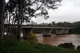
The Centenary Bridge is a motorway crossing of the Brisbane River
.
As it forms part of Brisbane's Centenary Motorway it is used primarily by vehicular traffic, although it includes footpaths for pedestrian traffic.
Built to service the new "Centenary" suburbs of Jindalee
, Mount Ommaney and Westlake
, the original two lane bridge opened in 1964. It was subsequently duplicated in the 1980s.
During the 1974 floods, the bridge was badly damaged when a barge rammed into its upstream side. The barge blocked the flow of floodwaters under the bridge and there were real fears that the bridge would collapse. The barge was deliberately holed using explosives and allowed to sink to reduce the floodwater pressure on the bridge. When the floodwater receded the barge was refloated and beached downstream near Fig Tree Pocket
to be cut up for scrap. The damage sustained by the bridge required its partial closure for repairs. For two years after the floods, the bridge was reduced to a single lane, with one way traffic controlled by traffic lights at each end of the bridge.
Brisbane River
The Brisbane River is the longest river in south east Queensland, Australia, and flows through the city of Brisbane, before emptying into Moreton Bay. John Oxley was the first European to explore the river who named it after the Governor of New South Wales, Thomas Brisbane in 1823...
.
As it forms part of Brisbane's Centenary Motorway it is used primarily by vehicular traffic, although it includes footpaths for pedestrian traffic.
Built to service the new "Centenary" suburbs of Jindalee
Jindalee, Queensland
Jindalee is an outer suburb of Brisbane, Australia located south-west of the Brisbane CBD, and is a part of the Centenary suburbs. It is bordered by the Brisbane River to the north. The Aboriginal meaning for Jindalee is "bare hills"...
, Mount Ommaney and Westlake
Westlake, Queensland
Westlake is a western suburb of Brisbane, Queensland, Australia. Westlake adjoins the suburbs of Jindalee, Middle Park and Mount Ommaney, and is a 20 minute drive from the Brisbane central business district....
, the original two lane bridge opened in 1964. It was subsequently duplicated in the 1980s.
During the 1974 floods, the bridge was badly damaged when a barge rammed into its upstream side. The barge blocked the flow of floodwaters under the bridge and there were real fears that the bridge would collapse. The barge was deliberately holed using explosives and allowed to sink to reduce the floodwater pressure on the bridge. When the floodwater receded the barge was refloated and beached downstream near Fig Tree Pocket
Fig Tree Pocket, Queensland
Fig Tree Pocket is a suburb of Brisbane, Australia located 8 km south-west of the Brisbane CBD on the Brisbane River. Placed within a pocket of the Brisbane River, the suburb is relatively remote, devoted mostly to low density housing...
to be cut up for scrap. The damage sustained by the bridge required its partial closure for repairs. For two years after the floods, the bridge was reduced to a single lane, with one way traffic controlled by traffic lights at each end of the bridge.