

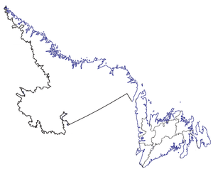
Census divisions of Newfoundland and Labrador
Encyclopedia
Canada
Canada is a North American country consisting of ten provinces and three territories. Located in the northern part of the continent, it extends from the Atlantic Ocean in the east to the Pacific Ocean in the west, and northward into the Arctic Ocean...
province of Newfoundland and Labrador
Newfoundland and Labrador
Newfoundland and Labrador is the easternmost province of Canada. Situated in the country's Atlantic region, it incorporates the island of Newfoundland and mainland Labrador with a combined area of . As of April 2011, the province's estimated population is 508,400...
is divided into 11 Census division
Census division
Census division is an official term in Canada and the United States. The census divisions of Canada are second-level census geographic unit, below provinces and territories, and above "census subdivisions" and "dissemination areas". In provinces where they exist, the census division may correspond...
s which are numbered 1 through 11.
List of census divisions
The region and largest community are listed:- Division No. 1, Newfoundland and LabradorDivision No. 1, Newfoundland and LabradorDivision No. 1, Newfoundland and Labrador is a census division covering the entire Avalon Peninsula including the Isthmus of Avalon of the Canadian province of Newfoundland and Labrador...
(Avalon PeninsulaAvalon PeninsulaThe Avalon Peninsula is a large peninsula that makes up the southeast portion of the island of Newfoundland.The peninsula is home to 257,223 people, which is approximately 51% of Newfoundland's population in 2009, and is the location of the provincial capital, St. John's. It is connected to the...
-St. John'sSt. John's, Newfoundland and LabradorSt. John's is the capital and largest city in Newfoundland and Labrador, and is the oldest English-founded city in North America. It is located on the eastern tip of the Avalon Peninsula on the island of Newfoundland. With a population of 192,326 as of July 1, 2010, the St...
) - Division No. 2, Newfoundland and Labrador (Burin PeninsulaBurin PeninsulaThe Burin Peninsula is a Canadian peninsula located on the south coast of the island of Newfoundland in the province of Newfoundland and Labrador....
-MarystownMarystown, Newfoundland and LabradorMarystown is a Canadian town in the province of Newfoundland and Labrador with a population of 5,436 . Situated 306 km from the province's capital, St. John's, it is on the Burin Peninsula. Up until the early 1990s, its economy was largely based on shipbuilding, and it is due in part to this...
) - Division No. 3, Newfoundland and Labrador (South Coast-Channel-Port aux BasquesChannel-Port aux Basques, Newfoundland and LabradorChannel-Port aux Basques is a town at the extreme southwestern tip of the island of Newfoundland fronting on the eastern end of the Cabot Strait. A Marine Atlantic ferry terminal is located in the town which is the primary entry point onto the island of Newfoundland and the western terminus of...
) - Division No. 4, Newfoundland and LabradorDivision No. 4, Newfoundland and LabradorCensus Division No. 4 is a Statistics Canada statistical division that comprises the areas of the province of Newfoundland and Labrador called St. George’s-Stephenville. It covers a land area of 7087.70 km² and had a population of 22,162 as of the 2001 census.-Municipalities:*Towns**Cape St...
(St. George's-StephenvilleStephenville, Newfoundland and LabradorStephenville is a Canadian town in Newfoundland and Labrador on the west coast of the island of Newfoundland....
) - Division No. 5, Newfoundland and LabradorDivision No. 5, Newfoundland and LabradorCensus Division No. 5 is a Statistics Canada statistical division composed of the areas of the province of Newfoundland and Labrador called Humber Valley, Bay of Islands, and White Bay...
(Humber District-Corner Brook) - Division No. 6, Newfoundland and LabradorDivision No. 6, Newfoundland and LabradorDivision No. 6 is a census division in the central part of the island of Newfoundland in the province of Newfoundland and Labrador, Canada. It is divided into 16 parts; 12 towns and four unorganized subdivisions....
(Central Newfoundland-Grand Falls-WindsorGrand Falls-Windsor, Newfoundland and LabradorGrand Falls-Windsor is a town of 13,558 people located in the central region of the island of Newfoundland in Newfoundland and Labrador, Canada. The town is the largest in the central region, the fifth largest in the province, and is home to the annual Exploits Valley Salmon Festival...
) - Division No. 7, Newfoundland and Labrador (BonavistaBonavista, Newfoundland and LabradorBonavista is a town on the Bonavista Peninsula, Newfoundland in the Canadian province of Newfoundland and Labrador. Unlike many Newfoundland coastal settlements, Bonavista was built on an open plain, not in a steep cove, and thus had room to expand to its current area of 31.5 square...
/Trinity-ClarenvilleClarenville, Newfoundland and LabradorClarenville is a Canadian town on the east coast of Newfoundland in the province of Newfoundland and Labrador. Clarenville was incorporated in 1951 and is located in the Shoal Harbour valley fronting an arm of the Atlantic Ocean called Random Sound....
) - Division No. 8, Newfoundland and LabradorDivision No. 8, Newfoundland and LabradorDivision No. 8 is a census division on the north coast of the island of Newfoundland in the province of Newfoundland and Labrador, Canada. It has a land area of 9,315.44 km² and a population of 42,188 as of the 2001 census...
(Notre Dame Bay-LewisporteLewisporte, Newfoundland and LabradorLewisporte is a town in central Newfoundland Island, Canada, with a population of 3,312. It is situated in a bay close to the mouth of the Exploits River. Lewisporte has an excellent port and related facilities that serve the many communities along Notre Dame Bay. Gander and its international...
) - Division No. 9, Newfoundland and LabradorDivision No. 9, Newfoundland and LabradorCensus Division No. 9 is composed of the area of the province of Newfoundland and Labrador called the Northern Peninsula. It has a land area of 13,526.85 km² and a population of 20,091 as of the 2001 census. The largest community is the town of St...
(Northern PeninsulaGreat Northern PeninsulaThe Great Northern Peninsula is the largest and longest peninsula of the island of Newfoundland, Canada, approximately 225 km long and 80 km wide at its widest point and encompassing an area of 17,483 km²...
-St. AnthonySt. Anthony, Newfoundland and Labrador-Attractions:* Is a popular tourist destination known for its whale watching.Dr. Wilfred Grenfell's work in St. Anthony is commemorated by several historic sites and museums, including:...
) - Division No. 10, Newfoundland and LabradorDivision No. 10, Newfoundland and LabradorCensus Division No. 10 is composed of the area of the province of Newfoundland and Labrador, Canada, called Labrador outside of Nunatsiavut. It has a land area of 269,073.3 km² and, as of the 2001 census, has a population of 27,864...
(LabradorLabradorLabrador is the distinct, northerly region of the Canadian province of Newfoundland and Labrador. It comprises the mainland portion of the province, separated from the island of Newfoundland by the Strait of Belle Isle...
-Happy Valley-Goose BayHappy Valley-Goose Bay, Newfoundland and LabradorHappy Valley – Goose Bay is a Canadian town in the province of Newfoundland and Labrador.Located in the central part of Labrador, the town is the largest population centre in that region. Incorporated in 1973, the town composes the former town of Happy Valley and the Local Improvement District of...
) - Division No. 11, Newfoundland and LabradorDivision No. 11, Newfoundland and LabradorCensus Division No. 11 is composed of the Nunatsiavut area of the province of Newfoundland and Labrador, Canada. Division 11 was used for the first time in the Canada 2006 Census; prior to 2006, Nunatsiavut was counted as part of Division 10....
(NunatsiavutNunatsiavutNunatsiavut is an autonomous area claimed by the Inuit in Newfoundland and Labrador, Canada. The settlement area includes territory in Labrador extending to the Quebec border. In 2002, the Labrador Inuit Association submitted a proposal for limited autonomy to the government of Newfoundland and...
-NainNain, Newfoundland and LabradorNain or Naina is the northernmost town of any size in the Canadian province of Newfoundland and Labrador, located about 370 kilometres by air from Happy Valley-Goose Bay. The town was established as a Moravian mission in 1771 by Jens Haven and other missionaries...
)
Historical Districts
Newfoundland was once divided into historical districts: http://ngb.chebucto.org/Districts/index.shtml- Bay de Verde
- Bonavista
- Burgeo and La Poile
- Burin
- Carbonear
- Ferryland
- Fogo
- Fortune Bay
- Harbour Grace
- Harbour Main
- Labrador
- Placentia and St. Mary's
- Port de Grave
- St. Barbe's
- St. George's-Port au Port
- St. John's East
- St. John's West
- Trinity
- Twillingate