
Cayo Batata
Encyclopedia
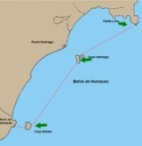
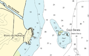
Cayo Batata is an uninhabited, grass-covered island
, located at 18°06′56"N 65°46′17"W, 600 m east of Morro de Humacao, the closest mainland feature (which is immediately south of the mouth of Río Humacao), in Humacao
, Puerto Rico
.
s (Block 3060, Block Group 3, Census Tract 1805, Humacao Municipio, Puerto Rico). The island is part of Río Abajo barrio
of Humacao.
A bare ledge, with five rocks and a reef, called Caballo Blanco (literally, White Horse, not to be confused with the islet of same name northwest of Vieques), awash and steep-to, is located 150 to 300 meters east and south of Cayo Batata.
Cayo Santiago
(Monkey Island), the second island belonging to Humacao, is located 5.7 km to the northeast.
Island
An island or isle is any piece of sub-continental land that is surrounded by water. Very small islands such as emergent land features on atolls can be called islets, cays or keys. An island in a river or lake may be called an eyot , or holm...
, located at 18°06′56"N 65°46′17"W, 600 m east of Morro de Humacao, the closest mainland feature (which is immediately south of the mouth of Río Humacao), in Humacao
Humacao, Puerto Rico
Humacao is a city in Puerto Rico located in the eastern coast of the island, north of Yabucoa; south of Naguabo; east of Las Piedras; and west of Vieques Passage. Humacao is spread over 10 wards and Humacao Pueblo...
, Puerto Rico
Puerto Rico
Puerto Rico , officially the Commonwealth of Puerto Rico , is an unincorporated territory of the United States, located in the northeastern Caribbean, east of the Dominican Republic and west of both the United States Virgin Islands and the British Virgin Islands.Puerto Rico comprises an...
.
Geography
The island is rectangular with sides between 60 and 70 m in length. It is up to 12.1 m high. The area is 4,679 m², or 1.16 acreAcre
The acre is a unit of area in a number of different systems, including the imperial and U.S. customary systems. The most commonly used acres today are the international acre and, in the United States, the survey acre. The most common use of the acre is to measure tracts of land.The acre is related...
s (Block 3060, Block Group 3, Census Tract 1805, Humacao Municipio, Puerto Rico). The island is part of Río Abajo barrio
Barrio
Barrio is a Spanish word meaning district or neighborhood.-Usage:In its formal usage in English, barrios are generally considered cohesive places, sharing, for example, a church and traditions such as feast days...
of Humacao.
A bare ledge, with five rocks and a reef, called Caballo Blanco (literally, White Horse, not to be confused with the islet of same name northwest of Vieques), awash and steep-to, is located 150 to 300 meters east and south of Cayo Batata.
Cayo Santiago
Cayo Santiago
Cayo Santiago, also known as Isla de los monos , is an uninhabited island, located at , 950 m southeast of Punta Santiago, Humacao, Puerto Rico.-Geography:...
(Monkey Island), the second island belonging to Humacao, is located 5.7 km to the northeast.