
Carrollwood Village, Florida
Encyclopedia
Carrollwood Village is an unincorporated community in Hillsborough County
, Florida
, United States
. Although a separate community, it is a part of the census-designated place
(CDP) of Greater Carrollwood
. The ZIP code
for the community is 33618. The community was a census-designated place during the 1990 census
, when the community recorded a population of 15,051.
for the community is 46 feet above sea level
.
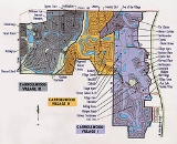
Carrollwood Village boundaries include Gunn Highway to the south, Dale Mabry Highway
to the east, Northdale to the north, and Citrus Park
to the west.
, Turner Road, Gunn Highway, and Ehrlich Road.
.
Hillsborough County, Florida
As of the census of 2000, there were 998,948 people, 391,357 households, and 255,164 families residing in the county. The population density was 951 people per square mile . There were 425,962 housing units at an average density of 405 per square mile...
, Florida
Florida
Florida is a state in the southeastern United States, located on the nation's Atlantic and Gulf coasts. It is bordered to the west by the Gulf of Mexico, to the north by Alabama and Georgia and to the east by the Atlantic Ocean. With a population of 18,801,310 as measured by the 2010 census, it...
, United States
United States
The United States of America is a federal constitutional republic comprising fifty states and a federal district...
. Although a separate community, it is a part of the census-designated place
Census-designated place
A census-designated place is a concentration of population identified by the United States Census Bureau for statistical purposes. CDPs are delineated for each decennial census as the statistical counterparts of incorporated places such as cities, towns and villages...
(CDP) of Greater Carrollwood
Greater Carrollwood, Florida
Greater Carrollwood is a census-designated place and an unincorporated census area located in northwestern Hillsborough County, Florida, United States. The population was 33,519 at the 2000 census. The census area includes the separate communities of Carrollwood and Carrollwood Village.- ZIP code...
. The ZIP code
ZIP Code
ZIP codes are a system of postal codes used by the United States Postal Service since 1963. The term ZIP, an acronym for Zone Improvement Plan, is properly written in capital letters and was chosen to suggest that the mail travels more efficiently, and therefore more quickly, when senders use the...
for the community is 33618. The community was a census-designated place during the 1990 census
United States Census, 1990
The Twenty-first United States Census, conducted by the Census Bureau, determined the resident population of the United States to be 248,709,873, an increase of 9.8 percent over the 226,545,805 persons enumerated during the 1980 Census....
, when the community recorded a population of 15,051.
Geography
Carrollwood Village is located at 28.1 degrees north, 82.5 degrees west (28.068, -82.521). The elevationElevation
The elevation of a geographic location is its height above a fixed reference point, most commonly a reference geoid, a mathematical model of the Earth's sea level as an equipotential gravitational surface ....
for the community is 46 feet above sea level
Sea level
Mean sea level is a measure of the average height of the ocean's surface ; used as a standard in reckoning land elevation...
.
Carrollwood Village boundaries include Gunn Highway to the south, Dale Mabry Highway
Dale Mabry Highway
Dale Mabry Highway is a north–south road in Tampa, Florida. The majority of its length consists of three lanes each direction plus a central turn-lane and often includes a right-turn lane. It begins at the MacDill Air Force Base entrance in South Tampa and ends by merging with US 41 just...
to the east, Northdale to the north, and Citrus Park
Citrus Park, Florida
Citrus Park is an unincorporated census-designated place in Hillsborough County, Florida, United States. The population was 24,252 at the 2010 census.-Geography:Citrus Park is located at , or about nine miles northwest of Tampa...
to the west.
Areas in Carrollwood Village
Carrollwood Village consists of the following areas.
|
|
|
|
Emerald Greens Golf and Country Club
Along with the developement of the housing community was the development of a 27 hole golf course, the Carrollwood Village Golf and Country Club. This course entertained some Senior PGA tournaments in the 1980's. The club changed names twice - first to the Country Club of Carrollwood in 2001, then to Emerald Greens Golf & Country Club in 2003. As Emerald Greens, all holes on the course were renovated or redesigned, a new club house and snack shack were built, along with Condo's, Vacation Villa's, resurfaced tennis courts and a new pool area.Transportation
Some of the major roads serving the community are Dale Mabry HighwayDale Mabry Highway
Dale Mabry Highway is a north–south road in Tampa, Florida. The majority of its length consists of three lanes each direction plus a central turn-lane and often includes a right-turn lane. It begins at the MacDill Air Force Base entrance in South Tampa and ends by merging with US 41 just...
, Turner Road, Gunn Highway, and Ehrlich Road.
Education
The community of Carrollwood Village is served by Hillsborough County SchoolsHillsborough County Public Schools
Hillsborough County Public Schools, Florida is a school district headquartered in Tampa, Florida. It is more commonly referred to as the School District of Hillsborough County, or SDHC....
.
See also
- CarrollwoodCarrollwood, FloridaCarrollwood is an unincorporated community in Hillsborough County, Florida, United States. Although a separate community, it is a part of the census-designated place of Greater Carrollwood. The ZIP code for the community is 33618...
- Greater CarrolllwoodGreater Carrollwood, FloridaGreater Carrollwood is a census-designated place and an unincorporated census area located in northwestern Hillsborough County, Florida, United States. The population was 33,519 at the 2000 census. The census area includes the separate communities of Carrollwood and Carrollwood Village.- ZIP code...