

Carrawburgh
Encyclopedia
Carrawburgh is a settlement in Northumberland
. In Roman times, it was the site of a 3½ acre (1.5 ha) auxiliary
fort on Hadrian's Wall
called Brocolitia, Procolita, or Brocolita This name is probably based on the Celtic name for the place, and one possible translation put forward is 'badger
holes'. The fort there was the Wall's northernmost point, and just over a mile west of the nearest milecastle
, Milecastle 30. It either used the Wall (narrow gauge on a broad base at this point) itself as its northern rampart, or was built parallel to it but detached. It certainly postdates both the Wall and the vallum
(which it is built across).
Only the fort's earthworks are now visible, the Wall at this point and the fort's north ramparts having been demolished for the construction of General Wade
's early 18th century military road (now the B6318). The late nineteenth century archaeologist John Clayton carried out a partial excavation of the site, revealing a military bath-house outside the fort's west gate (in 1873) and the fort's south-west corner-tower (in 1876).
The Roman Inscriptions of Britain
lists 48 inscriptions for the site. They show its garrisoning units to have been as follows:
The First Cohort of Frisiavones
are also attested at Brocolitia at some stage, as shown by an inscription on an altar stone, which tells us that Optio
Maus had repaid a vow to the goddess Coventina. (This unit is also recorded as present at Ardotalia
.) Whether this altar was the repayment of the vow is unknown.
 In the small vicus
on the low-lying marshy ground outside the fort's south-west corner have been found three religious sites, all connected with a small tributary stream of Meggie's Dene Burn, which runs three miles from Carrawburgh to empty into the River South Tyne
near Newbrough
's fort on the Stanegate
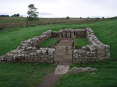
. Nearest to the fort was an early 3rd century Mithraeum
, of which remains can be seen onsite, and a reconstruction at Newcastle University's Museum of Antiquities
. It was discovered in 1949. Behind it was a nymphaeum
(found in 1957 and dug in 1960). The third site was "Coventina's Well", a centre for worship of the Romano-British goddess Coventina
found in Clayton's 1876 dig, and from which the stream sprung. No remains of the nymphaeum or Well can now be seen onsite.
Northumberland
Northumberland is the northernmost ceremonial county and a unitary district in North East England. For Eurostat purposes Northumberland is a NUTS 3 region and is one of three boroughs or unitary districts that comprise the "Northumberland and Tyne and Wear" NUTS 2 region...
. In Roman times, it was the site of a 3½ acre (1.5 ha) auxiliary
Auxiliaries (Roman military)
Auxiliaries formed the standing non-citizen corps of the Roman army of the Principate , alongside the citizen legions...
fort on Hadrian's Wall
Hadrian's Wall
Hadrian's Wall was a defensive fortification in Roman Britain. Begun in AD 122, during the rule of emperor Hadrian, it was the first of two fortifications built across Great Britain, the second being the Antonine Wall, lesser known of the two because its physical remains are less evident today.The...
called Brocolitia, Procolita, or Brocolita This name is probably based on the Celtic name for the place, and one possible translation put forward is 'badger
Badger
Badgers are short-legged omnivores in the weasel family, Mustelidae. There are nine species of badger, in three subfamilies : Melinae , Mellivorinae , and Taxideinae...
holes'. The fort there was the Wall's northernmost point, and just over a mile west of the nearest milecastle
Milecastle
A milecastle was a small fort , a rectangular fortification built during the period of the Roman Empire. They were placed at intervals of approximately one Roman mile along several major frontiers, for example Hadrian's Wall in Great Britain , hence the name.Along Hadrian's Wall, milecastles were...
, Milecastle 30. It either used the Wall (narrow gauge on a broad base at this point) itself as its northern rampart, or was built parallel to it but detached. It certainly postdates both the Wall and the vallum
Vallum (Hadrian's Wall)
The Vallum is a huge earthwork associated with Hadrian's Wall in England. Unique on any Roman frontier, it runs from coast to coast to the south of the wall....
(which it is built across).
Only the fort's earthworks are now visible, the Wall at this point and the fort's north ramparts having been demolished for the construction of General Wade
George Wade
Field Marshal George Wade served as a British military commander and Commander-in-Chief of the Forces.-Early career:Wade, born in Kilavally, Westmeath in Ireland, was commissioned into the Earl of Bath's Regiment in 1690 and served in Flanders in 1692, during the Nine Years War, earning a...
's early 18th century military road (now the B6318). The late nineteenth century archaeologist John Clayton carried out a partial excavation of the site, revealing a military bath-house outside the fort's west gate (in 1873) and the fort's south-west corner-tower (in 1876).
The Roman Inscriptions of Britain
Roman Inscriptions of Britain
The Roman Inscriptions of Britain is a multi-volume index of inscriptions found in Britain from the Roman period. It is an important reference work for all scholars of Roman Britain. This monumental work was initiated by Francis Haverfield – his notebooks were bequeathed to the University of...
lists 48 inscriptions for the site. They show its garrisoning units to have been as follows:
- RIB 1550 - Hadrianic? - First CohortCohort (military unit)A cohort was the basic tactical unit of a Roman legion following the reforms of Gaius Marius in 107 BC.-Legionary cohort:...
of AquitaniAquitaniThe Aquitani were a people living in what is now Aquitaine, France, in the region between the Pyrenees, the Atlantic ocean and the Garonne... - RIB 1563b - AD122-138 - First Cohort of TungriTungriThe Tungri were a tribe, or group of tribes, who lived in the Belgic part Gaul, during the times of the Roman empire. They were described by Tacitus as being the same people who were first called "Germani" , meaning that all other tribes who were later referred to this way, including those in...
- End 2nd century - Cohors I Cugernorum
- RIB 1544, RIB 1553, and Notitia Dignitarum - AD213-222? and AD237 respectively - First Cohort of BataviansBataviansThe Batavi were an ancient Germanic tribe, originally part of the Chatti, reported by Tacitus to have lived around the Rhine delta, in the area that is currently the Netherlands, "an uninhabited district on the extremity of the coast of Gaul, and also of a neighbouring island, surrounded by the...
The First Cohort of Frisiavones
Frisiavones
The Frisiavones were a Germanic tribe sometimes considered as a subdivision of the Frisii, who in turn are traditionally considered to be ancestors of modern Frisians. Pliny the Elder, however, appeared to distinguish them from the Frisii. They also appear in inscriptions found in Roman Britain...
are also attested at Brocolitia at some stage, as shown by an inscription on an altar stone, which tells us that Optio
Optio
An optio , sometimes anglicized option , was a soldier in the Roman army who held a position similar to that of an executive officer in modern armies...
Maus had repaid a vow to the goddess Coventina. (This unit is also recorded as present at Ardotalia
Ardotalia
Ardotalia is a Roman fort in Gamesley, near Glossop in Derbyshire, England .Ardotalia was constructed by Cohors Primae Frisiavonum—The First Cohort of Frisiavones. Evidence for the existence of this unit exists not only from the building stone found at the site but also from various diplomas and...
.) Whether this altar was the repayment of the vow is unknown.
Vicus (Rome)
In ancient Rome, the vicus was a neighborhood. During the Republican era, the four regiones of the city of Rome were subdivided into vici. In the 1st century BC, Augustus reorganized the city for administrative purposes into 14 regions, comprising 265 vici. Each vicus had its own board of...
on the low-lying marshy ground outside the fort's south-west corner have been found three religious sites, all connected with a small tributary stream of Meggie's Dene Burn, which runs three miles from Carrawburgh to empty into the River South Tyne
River Tyne
The River Tyne is a river in North East England in Great Britain. It is formed by the confluence of two rivers: the North Tyne and the South Tyne. These two rivers converge at Warden Rock near Hexham in Northumberland at a place dubbed 'The Meeting of the Waters'.The North Tyne rises on the...
near Newbrough
Newbrough
Newbrough is a village in Northumberland, England. The village lies on the north bank of the River South Tyne about west of Hexham.- History :...
's fort on the Stanegate
Stanegate
The Stanegate, or "stone road" , was an important Roman road built in what is now northern England. It linked two forts that guarded important river crossings; Corstopitum in the east, situated on Dere Street, and Luguvalium in the west...
. Nearest to the fort was an early 3rd century Mithraeum
Mithraeum
A Mithraeum is a place of worship for the followers of the mystery religion of Mithraism.The Mithraeum was either an adapted natural cave or cavern or an artificial building imitating a cavern. Mithraea were dark and windowless, even if they were not actually in a subterranean space or in a natural...
, of which remains can be seen onsite, and a reconstruction at Newcastle University's Museum of Antiquities
Museum of Antiquities
The Museum of Antiquities was an archaeological museum at the University of Newcastle upon Tyne, England. It opened in 1960 and in 2009 its collections were merged into the Great North Museum: Hancock.- History :...
. It was discovered in 1949. Behind it was a nymphaeum
Nymphaeum
A nymphaeum or nymphaion , in ancient Greece and Rome, was a monument consecrated to the nymphs, especially those of springs....
(found in 1957 and dug in 1960). The third site was "Coventina's Well", a centre for worship of the Romano-British goddess Coventina
Coventina
Coventina was a Romano-British goddess of wells and springs. She is known from multiple inscriptions at one site in Northumberland county of the United Kingdom, an area surrounding a wellspring near Carrawburgh on Hadrian's Wall...
found in Clayton's 1876 dig, and from which the stream sprung. No remains of the nymphaeum or Well can now be seen onsite.
External links
- BROCOLITIA at www.Roman-Britain.org
- BROCOLITIA FORT on the line of Hadrian's Wall as it exists today