

Cariaco Basin
Encyclopedia
Venezuela
Venezuela , officially called the Bolivarian Republic of Venezuela , is a tropical country on the northern coast of South America. It borders Colombia to the west, Guyana to the east, and Brazil to the south...
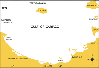
and forms the Gulf of Cariaco. It is bounded on the east by Margarita Island, Cubagua Island, and the Araya Pennisula; on the north by Tortuga Island
La Tortuga Island
La Tortuga Island is an uninhabited island dependent on the government of Venezuela. It is part of a chain of islands that include the Tortuguillas, the Palaquines, and others. Has an area of 156 km²-History:...
and the Tortuga Banks; on the west by Cape Codera and the rocks known as Farallón Centinela; and on the south by the coast of Venezuela.
The Cariaco Basin is an east-west trending pull-apart basin (Schubert, 1982) located on the continental shelf off the eastern coast of Venezuela
Venezuela
Venezuela , officially called the Bolivarian Republic of Venezuela , is a tropical country on the northern coast of South America. It borders Colombia to the west, Guyana to the east, and Brazil to the south...
. It is a deep depression composed of two sub-basins, the eastern basin and the western basin, each of ~1400m depth, separated by a saddle of ~900m. To the south, the basin confines with the wide (~50 km) Unare Platform.
It is connected to the open Caribbean Sea through two shallow (~140m) channels, to the north the (Tortuga Channel) and to the west the (Centinela Channel). Water circulation inside the basin is restricted, which, combined with the high annual primary productivity of the region (~500 gCm-2 yr-1), causes the basin to be permanently anoxic, below ~250m (Muller-Karger et al., 2001; 2004). This naturally occurring anoxic basin allows for sediments to be deposited without bioturbation
Bioturbation
In oceanography, limnology, pedology, geology , and archaeology, bioturbation is the displacement and mixing of sediment particles and solutes by fauna or flora . The mediators of bioturbation are typically annelid worms , bivalves In oceanography, limnology, pedology, geology (especially...
, forming varve
Varve
A varve is an annual layer of sediment or sedimentary rock.The word 'varve' is derived from the Swedish word varv whose meanings and connotations include 'revolution', 'in layers', and 'circle'. The term first appeared as Hvarfig lera on the first map produced by the Geological Survey of Sweden in...
s of alternating light and dark color, which correspond to the dry or rainy season (Haug et al., 2001). Its unique geography and undisturbed sediment record provides an excellent history of tropical climate change and is particularly sensitive to shifts in the Intertropical Convergence Zone
Intertropical Convergence Zone
The Intertropical Convergence Zone , known by sailors as The Doldrums, is the area encircling the earth near the equator where winds originating in the northern and southern hemispheres come together....
(ITCZ) (Peterson and Haug, 2006) and has been the subject of extensive paleoclimatological research.
Because of its anoxia, the Cariaco Basin has also a unique chemistry. Bacteria inhabit both the oxic and anoxic portions of the water column, with a maximum around the interface where oxygen disappears (Taylor et al., 2001). This 'interface' oscillates between 200 and 300 meters. As such unique location, the Cariaco Basin has been the site of a variety of studies since the mid-1950s. Since 1995, an international (Venezuela
Venezuela
Venezuela , officially called the Bolivarian Republic of Venezuela , is a tropical country on the northern coast of South America. It borders Colombia to the west, Guyana to the east, and Brazil to the south...
and United States
United States
The United States of America is a federal constitutional republic comprising fifty states and a federal district...
) program has expanded the research in the basin. The CARIACO (Carbon Retention in a Colored Ocean; http://www.imars.usf.edu/CAR/) program consists of a time series
Time series
In statistics, signal processing, econometrics and mathematical finance, a time series is a sequence of data points, measured typically at successive times spaced at uniform time intervals. Examples of time series are the daily closing value of the Dow Jones index or the annual flow volume of the...
station in the eastern deep of the basin which is visited on a monthly basis to collect hydrographic, nutrient and primary productivity measurements. A suite of other measurements, including a sediment trap mooring, microbiological studies and current measurements are also conducted at this site. The work that has resulted from the CARIACO ocean time series program has demonstrated that this anoxic basin is quite dynamic and has helped understand the paleoclimatic record stored in the basin's sediments.