

Cape Split
Encyclopedia
Headlands and bays
Headlands and bays are two related features of the coastal environment.- Geology and geography :Headlands and bays are often found on the same coastline. A bay is surrounded by land on three sides, whereas a headland is surrounded by water on three sides. Headlands are characterized by high,...
located on the Bay of Fundy
Bay of Fundy
The Bay of Fundy is a bay on the Atlantic coast of North America, on the northeast end of the Gulf of Maine between the Canadian provinces of New Brunswick and Nova Scotia, with a small portion touching the U.S. state of Maine...
coast of the Canadian
Canada
Canada is a North American country consisting of ten provinces and three territories. Located in the northern part of the continent, it extends from the Atlantic Ocean in the east to the Pacific Ocean in the west, and northward into the Arctic Ocean...
province of Nova Scotia
Nova Scotia
Nova Scotia is one of Canada's three Maritime provinces and is the most populous province in Atlantic Canada. The name of the province is Latin for "New Scotland," but "Nova Scotia" is the recognized, English-language name of the province. The provincial capital is Halifax. Nova Scotia is the...
.
Cape Split is located in Kings County
Kings County, Nova Scotia
Kings County is a county in the Canadian province of Nova Scotia.Kings County is located in central Nova Scotia on the shore of the Bay of Fundy with its northeastern part also forming the western shore of the Minas Basin....
and is a continuation of the North Mountain
North Mountain (Nova Scotia)
North Mountain is a narrow southwest-northeast trending volcanic mountain range on the mainland portion of southwestern Nova Scotia, stretching from Brier Island to Cape Split...
range, which is made of tholeiitic basalt. The cape separates the main part of the Bay of Fundy from the Minas Basin
Minas Basin
The Minas Basin is an inlet of the Bay of Fundy and a sub-basin of the Fundy Basin located in Nova Scotia, Canada. It is known for its extremely high tides.- Geography :- Boundary :...
, a sub-basin to the east.
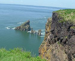
The cape itself is 7 km (4 mi) long and ranges between several kilometres to several dozen metres in width. Both sides of the headland end in high cliffs overlooking treacherous tidal currents in the Minas Channel.
Privately owned until recently, the property has now been sold to the Government of Nova Scotia and is being transformed into a provincial park.
A popular hiking trail has existed for decades on Cape Split, taking approximately 2–2.5 hours each way to the tip of the headland. Most of the Cape is heavily forested, but the tip of the peninsula is a meadow, providing excellent long-distance views in good weather.
The cliffs at Cape Split are actively eroding and potentially dangerous. The height of the cliffs is over 200 feet (70+ meters) and a fall could be fatal. There are several worn and eroded paths that appear to be trails, but actually lead to steep edges with loose soil and rocks underfoot.
See also
- Volcanism of Canada
- Volcanism of Eastern CanadaVolcanism of Eastern CanadaVolcanism of Eastern Canada has led to the formation of hundreds of volcanic areas and extensive lava formations, indicating volcanism played a major role in shaping its surface. The region's different volcano and lava types originate from different tectonic settings and types of volcanic...