
.gif)
North Mountain (Nova Scotia)
Encyclopedia
North Mountain is a narrow southwest-northeast trending volcanic
mountain range
on the mainland portion of southwestern Nova Scotia
, stretching from Brier Island to Cape Split. It forms the northern edge of the Annapolis Valley
along the shore of the Bay of Fundy
.
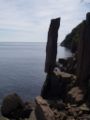
North Mountain rises dramatically from the valley floor and tapers somewhat more gradually to the north and west where it meets the coast, although many parts of this coast have vertical cliffs rising higher than 30 metres, most notably at Cape Split. A break occurs at Digby Gut
where a gap in the mountain ridge is filled by a deep tidal channel separating the eastern end of the mountain from Digby Neck
.
The highest point on the ridge is at Mount Rose in Annapolis County
, north of Lawrencetown
.
 The ridge traces its history to the Triassic
period when this part of Nova Scotia occupied the center of the supercontinent
Pangaea
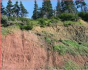
. It is a 201 million year old sequence of tholeiitic basalts, which contains columnar jointing. The basalts also extend under the Bay of Fundy and parts of it are exposed on the shore at Five Islands
, east of Parrsboro
on the north side of the bay. Numerous sediment-filled fissure
s are present near the upper surface of North Mountain. The hard ridge of basalt resisted the grinding of ice sheet
s that flowed over the region during past ice age
s, and now forms one side of the Annapolis Valley
in western part of the Nova Scotia peninsula
.
North Mountain is believed to have formed during the opening of the Atlantic Ocean
. It is a portion of the Central Atlantic Magmatic Province
, which is a gigantic flood basalt and intrusive complex along east coast of the United States
, Europe
, northwest Africa
and South America
with a diameter of 4,000 km.
A viscous (<175 m) North Mountain flow at McKay Head shows ~25-cm-thick distinguished layers separated by ~130 centimeter of basalt
in its upper 34 meters. Upper layers (5 meters below the lava
top) are extremely vesicular
while lower ones are pegmatitic and include a narrow (~2 cm) rhyolite
band. The layering of the flow closely resemble that of some Hawaii
an lava lake
s.
 Columnar basalt may be seen at Baxters Harbour
and at Brier Island
.
Volcano
2. Bedrock3. Conduit 4. Base5. Sill6. Dike7. Layers of ash emitted by the volcano8. Flank| 9. Layers of lava emitted by the volcano10. Throat11. Parasitic cone12. Lava flow13. Vent14. Crater15...
mountain range
Mountain range
A mountain range is a single, large mass consisting of a succession of mountains or narrowly spaced mountain ridges, with or without peaks, closely related in position, direction, formation, and age; a component part of a mountain system or of a mountain chain...
on the mainland portion of southwestern Nova Scotia
Nova Scotia peninsula
The Nova Scotia peninsula is a peninsula on the Atlantic coast of North America.-Location:The Nova Scotia peninsula is part of the province of Nova Scotia, Canada and is connected to the neighbouring province of New Brunswick through the Isthmus of Chignecto...
, stretching from Brier Island to Cape Split. It forms the northern edge of the Annapolis Valley
Annapolis Valley
The Annapolis Valley is a valley and region in the Canadian province of Nova Scotia. It is located in the western part of the Nova Scotia peninsula, formed by a trough between two parallel mountain ranges along the shore of the Bay of Fundy.-Geography:...
along the shore of the Bay of Fundy
Bay of Fundy
The Bay of Fundy is a bay on the Atlantic coast of North America, on the northeast end of the Gulf of Maine between the Canadian provinces of New Brunswick and Nova Scotia, with a small portion touching the U.S. state of Maine...
.
North Mountain rises dramatically from the valley floor and tapers somewhat more gradually to the north and west where it meets the coast, although many parts of this coast have vertical cliffs rising higher than 30 metres, most notably at Cape Split. A break occurs at Digby Gut
Digby Gut
The Digby Gut is a narrow channel connecting the Bay of Fundy with the Annapolis Basin. The town of Digby, Nova Scotia is located on the inner portion of the western side of the Gut. The eastern entrance is marked by the Point Prim lighthouse...
where a gap in the mountain ridge is filled by a deep tidal channel separating the eastern end of the mountain from Digby Neck
Digby Neck
Digby Neck is a Canadian peninsula extending into the Bay of Fundy in Digby County, Nova Scotia.Digby Neck is the western extension of the North Mountain range from the Annapolis Valley and is made of two thick lava flows. It is separated from the eastern portion of the North Mountain by a deep,...
.
The highest point on the ridge is at Mount Rose in Annapolis County
Annapolis County, Nova Scotia
Annapolis County is a county in the Canadian province of Nova Scotia located in the western part of the province on the Bay of Fundy. The county seat is Annapolis Royal.-History:...
, north of Lawrencetown
Lawrencetown, Annapolis County, Nova Scotia
Lawrencetown is a village within Annapolis County in the Annapolis Valley of Nova Scotia, Canada. As of 2006, the population was 668. Every year at the Lawrencetown Exhibition Grounds, the Annapolis Valley Exhibition is held, which is typically a very large gathering...
.
Geology
Triassic
The Triassic is a geologic period and system that extends from about 250 to 200 Mya . As the first period of the Mesozoic Era, the Triassic follows the Permian and is followed by the Jurassic. Both the start and end of the Triassic are marked by major extinction events...
period when this part of Nova Scotia occupied the center of the supercontinent
Supercontinent
In geology, a supercontinent is a landmass comprising more than one continental core, or craton. The assembly of cratons and accreted terranes that form Eurasia qualifies as a supercontinent today.-History:...
Pangaea
Pangaea
Pangaea, Pangæa, or Pangea is hypothesized as a supercontinent that existed during the Paleozoic and Mesozoic eras about 250 million years ago, before the component continents were separated into their current configuration....
. It is a 201 million year old sequence of tholeiitic basalts, which contains columnar jointing. The basalts also extend under the Bay of Fundy and parts of it are exposed on the shore at Five Islands
Five Islands, Nova Scotia
Five Islands is a rural community in Colchester County Nova Scotia with a population of 300 located on the north shore of the Minas Basin, home of the highest tides in the world...
, east of Parrsboro
Parrsboro, Nova Scotia
Parrsboro is a Canadian town located in Cumberland County, Nova Scotia.The town is known for its port on the Minas Basin, the Ship's Company Theatre productions and the Fundy Geological Museum.-History:...
on the north side of the bay. Numerous sediment-filled fissure
Fissure vent
A fissure vent, also known as a volcanic fissure or simply fissure, is a linear volcanic vent through which lava erupts, usually without any explosive activity. The vent is usually a few meters wide and may be many kilometers long. Fissure vents can cause large flood basalts and lava channels...
s are present near the upper surface of North Mountain. The hard ridge of basalt resisted the grinding of ice sheet
Ice sheet
An ice sheet is a mass of glacier ice that covers surrounding terrain and is greater than 50,000 km² , thus also known as continental glacier...
s that flowed over the region during past ice age
Ice age
An ice age or, more precisely, glacial age, is a generic geological period of long-term reduction in the temperature of the Earth's surface and atmosphere, resulting in the presence or expansion of continental ice sheets, polar ice sheets and alpine glaciers...
s, and now forms one side of the Annapolis Valley
Annapolis Valley
The Annapolis Valley is a valley and region in the Canadian province of Nova Scotia. It is located in the western part of the Nova Scotia peninsula, formed by a trough between two parallel mountain ranges along the shore of the Bay of Fundy.-Geography:...
in western part of the Nova Scotia peninsula
Nova Scotia peninsula
The Nova Scotia peninsula is a peninsula on the Atlantic coast of North America.-Location:The Nova Scotia peninsula is part of the province of Nova Scotia, Canada and is connected to the neighbouring province of New Brunswick through the Isthmus of Chignecto...
.
North Mountain is believed to have formed during the opening of the Atlantic Ocean
Atlantic Ocean
The Atlantic Ocean is the second-largest of the world's oceanic divisions. With a total area of about , it covers approximately 20% of the Earth's surface and about 26% of its water surface area...
. It is a portion of the Central Atlantic Magmatic Province
Central Atlantic Magmatic Province
The Central Atlantic magmatic province is a large connected magma flow formed during the breakup of Pangaea during the Mesozoic Era. The initial breakup of Pangaea in early Jurassic time provided a legacy of basaltic dikes, sills, and lavas over a vast area around the present central North...
, which is a gigantic flood basalt and intrusive complex along east coast of the United States
United States
The United States of America is a federal constitutional republic comprising fifty states and a federal district...
, Europe
Europe
Europe is, by convention, one of the world's seven continents. Comprising the westernmost peninsula of Eurasia, Europe is generally 'divided' from Asia to its east by the watershed divides of the Ural and Caucasus Mountains, the Ural River, the Caspian and Black Seas, and the waterways connecting...
, northwest Africa
Africa
Africa is the world's second largest and second most populous continent, after Asia. At about 30.2 million km² including adjacent islands, it covers 6% of the Earth's total surface area and 20.4% of the total land area...
and South America
South America
South America is a continent situated in the Western Hemisphere, mostly in the Southern Hemisphere, with a relatively small portion in the Northern Hemisphere. The continent is also considered a subcontinent of the Americas. It is bordered on the west by the Pacific Ocean and on the north and east...
with a diameter of 4,000 km.
A viscous (<175 m) North Mountain flow at McKay Head shows ~25-cm-thick distinguished layers separated by ~130 centimeter of basalt
Basalt
Basalt is a common extrusive volcanic rock. It is usually grey to black and fine-grained due to rapid cooling of lava at the surface of a planet. It may be porphyritic containing larger crystals in a fine matrix, or vesicular, or frothy scoria. Unweathered basalt is black or grey...
in its upper 34 meters. Upper layers (5 meters below the lava
Lava
Lava refers both to molten rock expelled by a volcano during an eruption and the resulting rock after solidification and cooling. This molten rock is formed in the interior of some planets, including Earth, and some of their satellites. When first erupted from a volcanic vent, lava is a liquid at...
top) are extremely vesicular
Vesicular texture
Vesicular texture is a volcanic rock texture characterised by a rock being pitted with many cavities at its surface and inside. The texture is often found in extrusive aphanitic, or glassy, igneous rock...
while lower ones are pegmatitic and include a narrow (~2 cm) rhyolite
Rhyolite
This page is about a volcanic rock. For the ghost town see Rhyolite, Nevada, and for the satellite system, see Rhyolite/Aquacade.Rhyolite is an igneous, volcanic rock, of felsic composition . It may have any texture from glassy to aphanitic to porphyritic...
band. The layering of the flow closely resemble that of some Hawaii
Hawaii
Hawaii is the newest of the 50 U.S. states , and is the only U.S. state made up entirely of islands. It is the northernmost island group in Polynesia, occupying most of an archipelago in the central Pacific Ocean, southwest of the continental United States, southeast of Japan, and northeast of...
an lava lake
Lava lake
Lava lakes are large volumes of molten lava, usually basaltic, contained in a volcanic vent, crater, or broad depression. The term is used to describe both lava lakes that are wholly or partly molten and those that are solidified...
s.
Baxters Harbour
Baxters Harbour is a former fishing community on the shore of the Bay of Fundy in Kings County, Nova Scotia, Canada, located 15 kilometres from Kentville. It was named for Dr. William Baxter and his son John Baxter who lived there in the early nineteenth century...
and at Brier Island
Brier Island
Brier Island is an island in the Bay of Fundy in Digby County, Nova Scotia.-Geography:The island is the western-most part of Nova Scotia and the southern end of the North Mountain ridge with Long Island lying immediately northeast; both islands constitute part of the Digby Neck...
.
See also
- Volcanism of Canada
- Volcanism of Eastern CanadaVolcanism of Eastern CanadaVolcanism of Eastern Canada has led to the formation of hundreds of volcanic areas and extensive lava formations, indicating volcanism played a major role in shaping its surface. The region's different volcano and lava types originate from different tectonic settings and types of volcanic...
- Fundy BasinFundy BasinThe Fundy Basin is a sediment-filled rift basin on the Atlantic coast of southeastern Canada. It contains three sub-basins; the Fundy sub-basin, the Minas Basin and the Chignecto Basin. These arms meet at the Bay of Fundy, which is contained within the rift valley. From the Bay of Fundy, the Minas...
- Geography of Nova ScotiaGeography of Nova ScotiaNova Scotia is a province located in eastern Canada fronting the Atlantic Ocean. One of the Maritime Provinces, Nova Scotia's geography is complex, despite its relatively small size in comparison to other Canadian provinces.-Physical geography:...
- List of highest points of Canadian provinces and territories