

Cape San Blas
Encyclopedia
Gulf County, Florida
Gulf County is a county located in the panhandle of the U.S. state of Florida. As of 2000, the population was 13,332. The U.S. Census Bureau 2005 estimate for the county is 13,975 . Its county seat is Port St. Joe.- History :...
extending westward from the mainland of Florida
Florida
Florida is a state in the southeastern United States, located on the nation's Atlantic and Gulf coasts. It is bordered to the west by the Gulf of Mexico, to the north by Alabama and Georgia and to the east by the Atlantic Ocean. With a population of 18,801,310 as measured by the 2010 census, it...
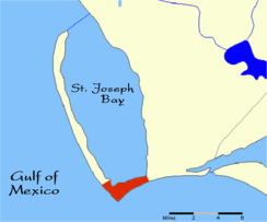
, separating St. Joseph Bay
St. Joseph Bay
St. Joseph Bay is a bay on the Gulf Coast of the U.S. state of Florida, located in Gulf County between Apalachicola and Panama City. Port St. Joe is located on St. Joseph Bay....
to the north from the Gulf Of Mexico
Gulf of Mexico
The Gulf of Mexico is a partially landlocked ocean basin largely surrounded by the North American continent and the island of Cuba. It is bounded on the northeast, north and northwest by the Gulf Coast of the United States, on the southwest and south by Mexico, and on the southeast by Cuba. In...
to the south. The St. Joseph Peninsula
St. Joseph Peninsula
The St. Joseph Peninsula is located in Gulf County, Florida in the panhandle of Florida, at coordinates . It is an 15-mile long spit, extending northward from Cape San Blas between the Gulf of Mexico to the west and Saint Joseph Bay to the east. It is 6 miles west of Port St. Joe at its closest...
extends northward from the west end of Cape San Blas. It is approximately 10 miles south-southwest of the town of Port St. Joe
Port St. Joe, Florida
Port St. Joe is a city located at the intersection of U.S. Highway 98 and State Road 71 in Gulf County, Florida, United States. As of 2007, the population estimated by the U.S. Census Bureau is 3,579. The population was 3,644 as of the 2000 census. Port St. Joe became the county seat of Gulf County...
, located at coordinates 29°39′49"N 85°21′20"W.
History
Cape San Blas was home to a ConfederateConfederate States of America
The Confederate States of America was a government set up from 1861 to 1865 by 11 Southern slave states of the United States of America that had declared their secession from the U.S...
Saltworks where 150 bushels of salt a day were processed by evaporation of seawater. This halted in 1862 when a landing party from the Union ship, the USS Kingfisher, destroyed the saltworks.
Cape San Blas has had 4 lighthouse
Lighthouse
A lighthouse is a tower, building, or other type of structure designed to emit light from a system of lamps and lenses or, in older times, from a fire, and used as an aid to navigation for maritime pilots at sea or on inland waterways....
s. The first, built in 1847, collapsed during a gale on August 23-24 of 1851. Congress appropriated $12,000 for a second brick tower lighthouse for the cape which was finally finished in November 1855, but it was destroyed on August 30, 1856, when another hurricane struck Cape San Blas. On May 1, 1858 a 3rd lighthouse was completed and lit. During the Civil War
American Civil War
The American Civil War was a civil war fought in the United States of America. In response to the election of Abraham Lincoln as President of the United States, 11 southern slave states declared their secession from the United States and formed the Confederate States of America ; the other 25...
the lighthouse was not in commission but resumed operations July 23, 1865. Over the years, erosion began eating away at the lighthouse. In 1883 the 4th iron frame lighthouse was constructed.