

Port St. Joe, Florida
Encyclopedia
Florida State Road 71
Florida State Road 71 is a road in western Florida that runs from the Alabama border through the panhandle of Florida to the Gulf Coast. Starting at the state line at the end of Alabama State Route 53 just south of Grangeburg, it runs south through the towns of Malone, Greenwood, Marianna, Altha,...
in Gulf County, Florida
Gulf County, Florida
Gulf County is a county located in the panhandle of the U.S. state of Florida. As of 2000, the population was 13,332. The U.S. Census Bureau 2005 estimate for the county is 13,975 . Its county seat is Port St. Joe.- History :...
, United States. As of 2007, the population estimated by the U.S. Census Bureau is 3,579. The population was 3,644 as of the 2000 census. Port St. Joe became the county seat
County seat
A county seat is an administrative center, or seat of government, for a county or civil parish. The term is primarily used in the United States....
of Gulf County in 1965.
Geography
Port St. Joe is located at 29°48′29"N 85°17′52"W (29.807968, -85.297684), within the Florida PanhandleFlorida Panhandle
The Florida Panhandle, an informal, unofficial term for the northwestern part of Florida, is a strip of land roughly 200 miles long and 50 to 100 miles wide , lying between Alabama on the north and the west, Georgia also on the north, and the Gulf of Mexico to the south. Its eastern boundary is...
and along the Emerald Coast
Emerald Coast
The Emerald Coast is an area in the US state of Florida on the coast of the Gulf of Mexico which stretches about 100 miles through four counties, Santa Rosa, Okaloosa, Walton, and Bay, from Gulf Breeze on the east side of Pensacola Bay to Panama City on the east side of the St...
. According to the United States Census Bureau
United States Census Bureau
The United States Census Bureau is the government agency that is responsible for the United States Census. It also gathers other national demographic and economic data...
, the city has a total area of 3.3 square miles (8.5 km²), all of it land. Port St. Joe averages only 3 feet above sea level. At its highest point it is only 8 feet above sea level. This portion of the town has been dubbed "Highland View".
Demographics
As of the census of 2000, there were 3,644 people, 1,402 households, and 1,030 families residing in the city. The population density was 1,097.4 people per square mile (423.8/km²). There were 1,571 housing units at an average density of 473.1 per square mile (182.7/km²). The racial makeup of the city was 68.52% White, 30.10% African American, 0.22% Native American, 0.22% Asian, 0.05% from other racesRace (United States Census)
Race and ethnicity in the United States Census, as defined by the Federal Office of Management and Budget and the United States Census Bureau, are self-identification data items in which residents choose the race or races with which they most closely identify, and indicate whether or not they are...
, and 0.88% from two or more races. Hispanic or Latino of any race were 0.55% of the population.
There were 1,402 households out of which 28.8% had children under the age of 18 living with them, 54.2% were married couples living together, 14.8% had a female householder with no husband present, and 26.5% were non-families. 24.9% of all households were made up of individuals and 14.0% had someone living alone who was 65 years of age or older. The average household size was 2.48 and the average family size was 2.94.
In the city the population was spread out with 23.6% under the age of 18, 6.7% from 18 to 24, 24.6% from 25 to 44, 23.6% from 45 to 64, and 21.5% who were 65 years of age or older. The median age was 42 years. For every 100 females there were 88.4 males. For every 100 females age 18 and over, there were 80.7 males.
The median income for a household in the city was $33,800, and the median income for a family was $39,489. Males had a median income of $30,244 versus $21,111 for females. The per capita income
Per capita income
Per capita income or income per person is a measure of mean income within an economic aggregate, such as a country or city. It is calculated by taking a measure of all sources of income in the aggregate and dividing it by the total population...
for the city was $16,205. About 11.2% of families and 13.0% of the population were below the poverty line, including 16.2% of those under age 18 and 11.7% of those age 65 or over.
Schools and libraries
Port St. Joe has one elementary school with Dolphins as mascot. It has a joint middle-high school with Tiger Sharks as mascots. The school colors are purple and gold. There is also a small private school, Faith Christian School. All of the public schools are located on one development strip set aside under the Department of Education. This begins with the elementary school and its playground and continues with the football stadium, a quarter mile running track, and finally the high school and adult school stretching a distance of about 5 city blocks. Port St. Joe also has a community college that offers two year associates degrees.Port St. Joe has a library co-located with the senior citizens center, Sheriff's office, courthouse, and animal shelter off HWY 71.
Port St. Joe almost became the capital of Florida in the 19th Century. The state constitution was ratified in 1838. There is a museum and monument commemorating this event.
Radio
- WEBZWEBZWEBZ is a commercial radio station located in Mexico Beach, Florida . Owned by Clear Channel Communications, the station broadcasts at 99.3 MHz...
99.3 FM (UrbanMainstream UrbanMainstream Urban is a term used to describe a radio format similar to an Urban Contemporary format. The format differentiates itself due to two factors: playlist composition and target demographic...
) - W216BT 91.1 FM (repeater of WFSW-FMWFSU-FMWFSU is the callsign for public radio stations operated by Florida State University in Tallahassee, Florida.WFSU also operates 3 radio stations that serve northern Florida:...
, Panama City) - WGBW-LP 88.5 FM (repeater of WDBW-LPWDBW-LPWDBW-LP is a non-commercial low-power FM radio station in Port St. Joe, Florida, broadcasting to the Panama City area. It is part of the Bible Broadcasting Network, along with Belleview-based WYFZ, Gainesville-based WYFB, Lakeland-based WYFO, and Tarpon Springs-based WYFE. WDBW's format is...
, Panama City) - WOCYWOCYWOCY is a radio station broadcasting a Top 40 format. Licensed to Carrabelle, Florida, USA and broadcasting from Port Saint Joe, Florida, USA...
106.5 Top 40 - WOYSWOYSWOYS is a radio station broadcasting a classic hits format, with beach music. Licensed to Apalachicola, Florida, USA, the station serves Franklin / Gulf / Wakulla County in Northern Florida. The station is currently owned by 3G Broadcasting Inc...
100.5 Classic Hits
Water
Port St. Joe is traversed by the Gulf Intracoastal WaterwayGulf Intracoastal Waterway
The Gulf Intracoastal Waterway is the portion of the Intracoastal Waterway located along the Gulf Coast of the United States. It is a navigable inland waterway running approximately 1700 kilometers from Carrabelle, Florida, to Brownsville, Texas.The waterway provides a channel with a controlling...
(GIWW), a federally maintained canal with a channel of 12 feet (3.6 m) deep by 125 feet (38 m) wide, which provides access from St. Marks, Florida
St. Marks, Florida
St. Marks is a city in Wakulla County, Florida, United States. It is part of the Tallahassee, Florida, Metropolitan Statistical Area. The population was 272 at the 2000 census. As of 2004, the population estimated by the U.S. Census Bureau is 299 .-Geography:...
, to Brownsville, Texas
Brownsville, Texas
Brownsville is a city in the southernmost tip of the state of Texas, in the United States. It is located on the northern bank of the Rio Grande, directly north and across the border from Matamoros, Tamaulipas, Mexico. Brownsville is the 16th largest city in the state of Texas with a population of...
. From the GIWW, barges can be moved inland on various river systems including the Mississippi River
Mississippi River
The Mississippi River is the largest river system in North America. Flowing entirely in the United States, this river rises in western Minnesota and meanders slowly southwards for to the Mississippi River Delta at the Gulf of Mexico. With its many tributaries, the Mississippi's watershed drains...
, Tombigbee River
Tombigbee River
The Tombigbee River is a tributary of the Mobile River, approximately 200 mi long, in the U.S. states of Mississippi and Alabama. It is one of two major rivers, along with the Alabama River, that unite to form the short Mobile River before it empties into Mobile Bay on the Gulf of Mexico...
Waterway System, and the Apalachicola River
Apalachicola River
The Apalachicola River is a river, approximately 112 mi long in the State of Florida. This river's large watershed, known as the ACF River Basin for short, drains an area of approximately into the Gulf of Mexico. The distance to its farthest headstream in northeast Georgia is approximately 500...
. The Apalachicola River is Gulf County's eastern boundary.
The Port of Port St. Joe shipping channel is Congressionally authorized to a depth of 35 feet (110.7 m) and connects to the shipping lanes of the Gulf of Mexico
Gulf of Mexico
The Gulf of Mexico is a partially landlocked ocean basin largely surrounded by the North American continent and the island of Cuba. It is bounded on the northeast, north and northwest by the Gulf Coast of the United States, on the southwest and south by Mexico, and on the southeast by Cuba. In...
and to the world. Existing facilities include a manufacturer of chemical line from dolomite, a chemical plant, a 9 million ton/year, dry bulk, barge to rail transloading terminal, and a builder of dive-cruise ships.
Rail
The AN RailwayAN Railway
The AN Railway is one of several shortline railroad companies owned by the Genesee & Wyoming parent company. It operates between Port Saint Joe, Florida and a connection with CSX's Pensacola & Atlantic and Tallahassee Subdivisions at Chattahoochee, Florida, with a short spur to Apalachicola, Florida...
serves the industries and port of Port St. Joe and has a history of transporting a variety of products including wood chips and other forest products, chemicals, and coal. In light of the latter, most of its 96-mile mainline consists of heavy duty, 140 lb. rail on concrete ties. The AN connects with the Class I CSX Transportation
CSX Transportation
CSX Transportation operates a Class I railroad in the United States known as the CSX Railroad. It is the main subsidiary of the CSX Corporation. The company is headquartered in Jacksonville, Florida, and owns approximately 21,000 route miles...
at Chattahoochee, Florida
Chattahoochee, Florida
Chattahoochee is a city in Gadsden County, Florida, United States. The population was 3,287 at the 2000 census. According to the U.S Census estimates of 2005, the city had a population of 3,720. It is part of the Tallahassee, Florida Metropolitan Statistical Area.-Geography:Chattahoochee is...
.
Highway
Gulf County's highway transportation needs are met with three main corridors: U.S. Route 98U.S. Route 98
U.S. Route 98 is an east–west United States highway that runs from western Mississippi to southern Florida. It was established in 1933 as a route between Pensacola, Florida and Apalachicola, Florida, and has since been extended westward into Mississippi and eastward across the Florida...
along the coast and through Port St. Joe providing a route west to Panama City, Florida
Panama City, Florida
-Personal income:The median income for a household in the city was $31,572, and the median income for a family was $40,890. Males had a median income of $30,401 versus $21,431 for females. The per capita income for the city was $17,830...
and east to Apalachicola, Florida
Apalachicola, Florida
Apalachicola is a city in Franklin County, Florida, on US 98 about southwest of Tallahassee. The population was 2,334 at the 2000 census. The 2005 census estimated the city's population at 2,340...
, State Road 22
Florida State Road 22
State Road 22 runs east and west from US 98 Business in Springfield to SR 71 in Wewahitchka. SR 22 is known as East 3rd Street in Springfield and Wewa Highway from Callaway to Wewahitchka. With the exception of the intersection with US 98 in Callaway, SR 22 is entirely a two-lane undivided...
westward from Wewahitchka, Florida
Wewahitchka, Florida
Wewahitchka is a city in Gulf County, Florida, United States. The population was 1,722 at the 2000 census. According to the U.S. Census Bureau's 2004 estimates, the city had a population of 1,703.-Geography:...
to Panama City, Florida
Panama City, Florida
-Personal income:The median income for a household in the city was $31,572, and the median income for a family was $40,890. Males had a median income of $30,401 versus $21,431 for females. The per capita income for the city was $17,830...
, and State Road 71
Florida State Road 71
Florida State Road 71 is a road in western Florida that runs from the Alabama border through the panhandle of Florida to the Gulf Coast. Starting at the state line at the end of Alabama State Route 53 just south of Grangeburg, it runs south through the towns of Malone, Greenwood, Marianna, Altha,...
from Port St. Joe northward toward Alabama
Alabama
Alabama is a state located in the southeastern region of the United States. It is bordered by Tennessee to the north, Georgia to the east, Florida and the Gulf of Mexico to the south, and Mississippi to the west. Alabama ranks 30th in total land area and ranks second in the size of its inland...
and Georgia
Georgia (U.S. state)
Georgia is a state located in the southeastern United States. It was established in 1732, the last of the original Thirteen Colonies. The state is named after King George II of Great Britain. Georgia was the fourth state to ratify the United States Constitution, on January 2, 1788...
. Further, State Road 71 provides a low traffic connection to Interstate 10
Interstate 10
Interstate 10 is the fourth-longest Interstate Highway in the United States, after I-90, I-80, and I-40. It is the southernmost east–west, coast-to-coast Interstate Highway, although I-4 and I-8 are further south. It stretches from the Pacific Ocean at State Route 1 in Santa Monica,...
, with only two traffic signals between Port St. Joe and Interstate 10.
See also
- Centennial BuildingCentennial BuildingThe Centennial Building is a historic site in Port St. Joe, Florida, It is located at 300 Allen Memorial Way, across from the Constitution Convention Museum State Park. On March 12, 1996, it was added to the U.S. National Register of Historic Places.-References:* at * ** **...
- Constitution Convention Museum State ParkConstitution Convention Museum State ParkConstitution Convention Museum State Park is a Florida State Park located just outside of Port St. Joe, off U.S. 98, in northwestern Florida. The park contains a museum with examples of 19th century life in the former town of St. Joseph, and features life-sized figures with audio presentations...
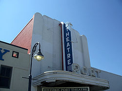
- Port TheatrePort TheatreThe Port Theatre is a historic site in Port St. Joe, Florida, located at 314 Reid Avenue. On June 5, 2003, it was added to the U.S. National Register of Historic Places.-References:* at * at...
- St. Joseph, FloridaSt. Joseph, FloridaSt. Joseph, Florida, was a boomtown that briefly became the largest community in Florida, before being destroyed only eight years after it was founded. St. Joseph was founded in 1835 on the shores of St. Joseph Bay, one of the finest natural harbors on the Gulf Coast of the United States. The...
- St. Joseph Catholic Mission ChurchSt. Joseph Catholic Mission ChurchThe St. Joseph Catholic Mission Church is a historic site in Port St. Joe, Florida, located at 216 8th Street. On July 31, 1998, it was added to the U.S. National Register of Historic Places.-References:...
External links
- Gulf County Tourist Development Council
- Gulf County Chamber of Commerce
- The Star newspaper that serves Port St. Joe, Florida is available in full-text with images in Florida Digital Newspaper Library