
Cann River, Victoria
Encyclopedia
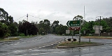
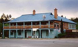
Cann River is a town in Victoria, Australia
, located on the Cann River
at the junction of the Princes Highway
and Monaro Highway
, in the Shire of East Gippsland. At the 2006 census
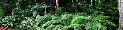
, Cann River had a population of 223. The town is close to Lind National Park
, Coopracambra National Park
, and Croajingolong National Park
, and is a popular stopping point for travellers between Melbourne
and Sydney
using the Princes Highway route.
The Post Office opened on 1 July 1890.
Australia
Australia , officially the Commonwealth of Australia, is a country in the Southern Hemisphere comprising the mainland of the Australian continent, the island of Tasmania, and numerous smaller islands in the Indian and Pacific Oceans. It is the world's sixth-largest country by total area...
, located on the Cann River
Cann River
The Cann River is a river of Gippsland in southeastern Victoria, Australia. It arises in the Bondi Forest in New South Wales and flows south to the Croajingolong National Park before entering Bass Strait via Tamboon Inlet....
at the junction of the Princes Highway
Princes Highway
The Princes Highway extends from Sydney to Port Augusta via the coast through the states of New South Wales, Victoria and South Australia, a distance of 1941 km or 1898 km via the former alignments of the highway ....
and Monaro Highway
Monaro Highway
The Monaro Highway is a state highway in New South Wales, the Australian Capital Territory and Victoria, Australia. The Victorian section was formerly known as the Cann Valley Highway until the 1980s....
, in the Shire of East Gippsland. At the 2006 census
Census in Australia
The Australian census is administered once every five years by the Australian Bureau of Statistics. The most recent census was conducted on 9 August 2011; the next will be conducted in 2016. Prior to the introduction of regular censuses in 1961, they had also been run in 1901, 1911, 1921, 1933,...
, Cann River had a population of 223. The town is close to Lind National Park
Lind National Park
Lind National Park is a national park in eastern Gippsland, in Victoria, Australia, 353 kilometres east of Melbourne. It is situated on the Princes Highway between Orbost and Cann River....
, Coopracambra National Park
Coopracambra National Park
Coopracambra is a national park in eastern Victoria, Australia, 380 kilometres east of Melbourne....
, and Croajingolong National Park
Croajingolong National Park
Croajingolong is a coastal national park in Victoria, Australia, 427 kilometres east of Melbourne.The name is thought to derive from the aboriginal word Krowathunkooloong, the name of the tribe inhabiting that area of Victoria.-Description:...
, and is a popular stopping point for travellers between Melbourne
Melbourne
Melbourne is the capital and most populous city in the state of Victoria, and the second most populous city in Australia. The Melbourne City Centre is the hub of the greater metropolitan area and the Census statistical division—of which "Melbourne" is the common name. As of June 2009, the greater...
and Sydney
Sydney
Sydney is the most populous city in Australia and the state capital of New South Wales. Sydney is located on Australia's south-east coast of the Tasman Sea. As of June 2010, the greater metropolitan area had an approximate population of 4.6 million people...
using the Princes Highway route.
The Post Office opened on 1 July 1890.