

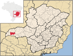
Campina Verde
Encyclopedia
Minas Gerais
Minas Gerais is one of the 26 states of Brazil, of which it is the second most populous, the third richest, and the fourth largest in area. Minas Gerais is the Brazilian state with the largest number of Presidents of Brazil, the current one, Dilma Rousseff, being one of them. The capital is the...
. As of 2007 the population was 18,680 in a total area of 3,663 km². It became a municipality in 1938.
Location
Campina Verde is located at an elevation of 530 meters north of the Rio Grande River, a tributary of the Paraná RiverParaná River
The Paraná River is a river in south Central South America, running through Brazil, Paraguay and Argentina for some . It is second in length only to the Amazon River among South American rivers. The name Paraná is an abbreviation of the phrase "para rehe onáva", which comes from the Tupi language...
. It is 70 km. west of federal highway BR-153 (Transbrasiliana). It belongs to the statistical microregion of Frutal
Frutal
Frutal is a municipality in the west of the Brazilian state of Minas Gerais. The population, measured in 2010 by the IBGE, is of 53,468 inhabitants. The city has an area of 2,427 km²...
. Neighboring municipalities are:
- Northwest: Santa VitóriaSanta Vitória, Minas GeraisSanta Vitória is a municipality in the west of the Brazilian state of Minas Gerais. , the population was 18,157. It became a municipality in 1948....
- North: ItuiutabaItuiutabaItuiutaba is a city and municipality in the western part of Minas Gerais state, Brazil. Elevated to city status in 1901, it had a population in 2007 of 100,316 and a total area in the municipality of 2,694 km²...
- East and Northeast: Prata
- West: Itapagibe
- Southwest: IturamaIturamaIturama is a municipality in the west of the Brazilian state of Minas Gerais. As of 2007 the population was 31,495 in a total area of 1,401 km². It became a municipality in 1948.-Location:...
- South: São Francisco de SalesSão Francisco de SalesSão Francisco de Sales is a municipality in the west of the Brazilian state of Minas Gerais. As of 2007 the population was 5,167 in a total area of 1,129 km². It became a municipality in 1962.-Location:...
- Southeast:ItapagipeItapagipeItapagipe is a municipality in the west of the Brazilian state of Minas Gerais. As of 2007 the population was 14,019 in a total area of 1,795 km². It became a municipality in 1885.-Location:...
and União de MinasUnião de Minas-Location:União de Minas belongs to the statistical micro-region of Frutal. It is located at an elevation of 521 meters between the São Domingos River and the Grande River.Neighboring municipalities are:*North: Santa Vitória*West: Limeira do Oeste...
Distances
- Belo HorizonteBelo HorizonteBelo Horizonte is the capital of and largest city in the state of Minas Gerais, located in the southeastern region of Brazil. It is the third largest metropolitan area in the country...
: 720 km. - UberabaUberabaUberaba is a city and municipality in the west of the state of Minas Gerais in Brazil. Its population is 296.000 with an area of 4529.7 km², giving a density of 60.71 people per km². It is located on a plateau at an elevation of 785 meters and is in the Uberaba River floodplain...
: 145 km. - UberlândiaUberlândiaUberlândia is the main town in the Triangle region, west of the state of Minas Gerais, Brazil. With a population of 604,013 inhabitants, according to 2010 estimates, the city is the second largest in the state second only to Belo Horizonte...
: 151 km. - ItuiutabaItuiutabaItuiutaba is a city and municipality in the western part of Minas Gerais state, Brazil. Elevated to city status in 1901, it had a population in 2007 of 100,316 and a total area in the municipality of 2,694 km²...
: 185 km.
Economic activities
The most important economic activities are cattle raising, commerce, light industry, food processing, and agriculture. The GDP in 2005 was R$ 181,515,000. Campina Verde is in the top tier of municipalities in the state with regard to economic and social development. As of 2007 there were 04 banking agencies in the town. There was a dynamic retail infrastructure serving the surrounding area of cattle and agricultural lands. In the rural area there were 1,861 establishments occupying about 4,500 workers. 530 of the farms had tractors, a ratio of one in three. There were 2,223 automobiles in all of the municipality, about one for every 8 inhabitants.Campina Verde is an important agricultural producer and a large producer of meat and dairy products. There were 354,000 head of cattle in 2006, of which 55,000 head were dairy cows. The crops with a planted area of more than 100 hectares were:
- oranges: 167 ha.
- corn: 5,000 ha.
- soybeans: 2,500 ha.
Health and education
In the health sector there were 09 health clinics and 01 hospital with 29 beds. In the educational sector there were 4 primary schools and 02 middle schools. There was 01 institute of higher learning.- Municipal Human Development IndexHuman Development IndexThe Human Development Index is a composite statistic used to rank countries by level of "human development" and separate "very high human development", "high human development", "medium human development", and "low human development" countries...
: 0.795 (2000) - State ranking: 55 out of 853 municipalities as of 2000
- National ranking: 670 out of 5,138 municipalities as of 2000
- Literacy rate: 88%
- Life expectancy: 74.7 (average of males and females)
The highest ranking municipality in Minas Gerais in 2000 was Poços de Caldas
Poços de Caldas
Poços de Caldas is a city and municipality in south-western Minas Gerais state, Brazil, in the microregion of the same name. Its estimated population in 2009 was 151,449 inhabitants...
with 0.841, while the lowest was Setubinha
Setubinha
Setubinha is a municipality in the northeast of the Brazilian state of Minas Gerais. As of 2007 the population was 10,834 in a total area of 536 km². The elevation is 729 metres. It is part of the IBGE statistical microregion of Teófilo Otoni...
with 0.568. Nationally the highest was São Caetano do Sul
São Caetano do Sul
São Caetano do Sul is a city in São Paulo state in Brazil, located in the Greater São Paulo Metropolitan Area. It is the city with the highest per capita income in Brazil and it also has the highest Human Development Index .-Geography:São Caetano do Sul is located on a plateau that is part of the...
in São Paulo with 0.919, while the lowest was Setubinha. In more recent statistics (considering 5,507 municipalities) Manari in the state of Pernambuco
Pernambuco
Pernambuco is a state of Brazil, located in the Northeast region of the country. To the north are the states of Paraíba and Ceará, to the west is Piauí, to the south are Alagoas and Bahia, and to the east is the Atlantic Ocean. There are about of beaches, some of the most beautiful in the...
has the lowest rating in the country—0,467—putting it in last place.
History
According to oral tradition the name of the city is linked to the cattle ranch called Fazenda Campo Belo da Farinha Podre. Before 1815 João Batista Siqueira and Bárbara Buena da Silva, took possession of a large area of lands in the region between the Rio Grande and the Paranaíba rivers. The settlement grew and in 1923 it became a district of the municipality of Prata with the name Campina Verde. In 1938 it got its municipal emancipation and included the districts of IturamaIturama
Iturama is a municipality in the west of the Brazilian state of Minas Gerais. As of 2007 the population was 31,495 in a total area of 1,401 km². It became a municipality in 1948.-Location:...
and São Francisco de Sales
São Francisco de Sales
São Francisco de Sales is a municipality in the west of the Brazilian state of Minas Gerais. As of 2007 the population was 5,167 in a total area of 1,129 km². It became a municipality in 1962.-Location:...
. In 1948 Iturama was separated, being followed by São Francisco de Sales in 1962.
See also
- List of municipalities in Minas Gerais