

São Francisco de Sales
Encyclopedia
Minas Gerais
Minas Gerais is one of the 26 states of Brazil, of which it is the second most populous, the third richest, and the fourth largest in area. Minas Gerais is the Brazilian state with the largest number of Presidents of Brazil, the current one, Dilma Rousseff, being one of them. The capital is the...
. As of 2007 the population was 5,167 in a total area of 1,129 km². It became a municipality in 1962.
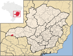
Location
São Francisco de Sales belongs to the statistical micro-region of FrutalFrutal
Frutal is a municipality in the west of the Brazilian state of Minas Gerais. The population, measured in 2010 by the IBGE, is of 53,468 inhabitants. The city has an area of 2,427 km²...
. It is located at an elevation of 423 meters on the northern bank of the Rio Grande River and is crossed by the Verde River. Neighboring municipalities are:
- North: Campina VerdeCampina VerdeCampina Verde is a municipality in the north of the Brazilian state of Minas Gerais. As of 2007 the population was 18,680 in a total area of 3,663 km². It became a municipality in 1938.-Location:...
- West: IturamaIturamaIturama is a municipality in the west of the Brazilian state of Minas Gerais. As of 2007 the population was 31,495 in a total area of 1,401 km². It became a municipality in 1948.-Location:...
- East: ItapagipeItapagipeItapagipe is a municipality in the west of the Brazilian state of Minas Gerais. As of 2007 the population was 14,019 in a total area of 1,795 km². It became a municipality in 1885.-Location:...
- South: the state of São PauloSão PauloSão Paulo is the largest city in Brazil, the largest city in the southern hemisphere and South America, and the world's seventh largest city by population. The metropolis is anchor to the São Paulo metropolitan area, ranked as the second-most populous metropolitan area in the Americas and among...
Distances
- Campina VerdeCampina VerdeCampina Verde is a municipality in the north of the Brazilian state of Minas Gerais. As of 2007 the population was 18,680 in a total area of 3,663 km². It became a municipality in 1938.-Location:...
: - IturamaIturamaIturama is a municipality in the west of the Brazilian state of Minas Gerais. As of 2007 the population was 31,495 in a total area of 1,401 km². It became a municipality in 1948.-Location:...
: 50 km - ItapagipeItapagipeItapagipe is a municipality in the west of the Brazilian state of Minas Gerais. As of 2007 the population was 14,019 in a total area of 1,795 km². It became a municipality in 1885.-Location:...
: 43 km - FrutalFrutalFrutal is a municipality in the west of the Brazilian state of Minas Gerais. The population, measured in 2010 by the IBGE, is of 53,468 inhabitants. The city has an area of 2,427 km²...
: 92 - Belo HorizonteBelo HorizonteBelo Horizonte is the capital of and largest city in the state of Minas Gerais, located in the southeastern region of Brazil. It is the third largest metropolitan area in the country...
: 692
The highways of access are: BR-262, BR-050, MG-427, BR-364, and MG-255.
History
The town had its origins in an Indian village, located on the banks of the Rio Verde. Around 1835 a priest, Jerônimo Gonçalves Macedo, arrived and put up a cross. In 1850 a district was formed with the name "Missões", later changed to São Francisco de Sales in homage to the founder of the Salesian order. In 1962 the district was dismembered from Campina VerdeCampina Verde
Campina Verde is a municipality in the north of the Brazilian state of Minas Gerais. As of 2007 the population was 18,680 in a total area of 3,663 km². It became a municipality in 1938.-Location:...
to become a municipality.
Economic activities
The most important economic activities are cattle raising, commerce, and agriculture. The GDP in 2005 was R$ R$54 million of which half came from agriculture. São Francisco de Sales is in the top tier of municipalities in the state with regard to economic and social development. As of 2007 there were no banking agencies in the town. There was a small retail infrastructure serving the surrounding area of cattle and agricultural lands. There were 628 automobiles in all of the municipality, about one for every 8 inhabitants.In the rural area there were 298 establishments occupying 58,000 hectares. About 600 persons were employed in agriculture. 125 of the farms had tractors, a ratio of one in four farms. There were 101,000 head of cattle in 2006, of which 22,000 head were dairy cows. In permanent crops there were 1,500 ha. planted, while in perennial crops 2,200 ha. were planted (2006). The crops with a planted area of more than 1,000 hectares were sugarcane, corn, and soybeans.
Health and education
In the health sector there was 01 health clinic and 01 hospital with 11 beds. In the educational sector there was 01 primary school and 01 middle school.- Municipal Human Development IndexHuman Development IndexThe Human Development Index is a composite statistic used to rank countries by level of "human development" and separate "very high human development", "high human development", "medium human development", and "low human development" countries...
: 0.786 (2000) - State ranking: 95 out of 853 municipalities as of 2000
- National ranking: 917 out of 5,138 municipalities as of 2000
- Literacy rate: 88%
- Life expectancy: 73 (average of males and females)
The highest ranking municipality in Minas Gerais in 2000 was Poços de Caldas
Poços de Caldas
Poços de Caldas is a city and municipality in south-western Minas Gerais state, Brazil, in the microregion of the same name. Its estimated population in 2009 was 151,449 inhabitants...
with 0.841, while the lowest was Setubinha
Setubinha
Setubinha is a municipality in the northeast of the Brazilian state of Minas Gerais. As of 2007 the population was 10,834 in a total area of 536 km². The elevation is 729 metres. It is part of the IBGE statistical microregion of Teófilo Otoni...
with 0.568. Nationally the highest was São Caetano do Sul
São Caetano do Sul
São Caetano do Sul is a city in São Paulo state in Brazil, located in the Greater São Paulo Metropolitan Area. It is the city with the highest per capita income in Brazil and it also has the highest Human Development Index .-Geography:São Caetano do Sul is located on a plateau that is part of the...
in São Paulo with 0.919, while the lowest was Setubinha. In more recent statistics (considering 5,507 municipalities) Manari in the state of Pernambuco
Pernambuco
Pernambuco is a state of Brazil, located in the Northeast region of the country. To the north are the states of Paraíba and Ceará, to the west is Piauí, to the south are Alagoas and Bahia, and to the east is the Atlantic Ocean. There are about of beaches, some of the most beautiful in the...
has the lowest rating in the country—0,467—putting it in last place.
See also
- List of municipalities in Minas Gerais