
Cambridge and Huntingdon railway
Encyclopedia
The Cambridge & St. Ives Branch (as it is named on New Popular Editions Ordnance Survey
maps) was a railway built by the Wisbech, St Ives & Cambridge Junction Railway in the late 1840s. The railway ran from Cambridge
in the south, through Fenland countryside to the market town of St. Ives; more specifically, the line ran from Chesterton Junction, where it met the present-day Fen Line
north of the River Cam
. Passenger services along the line managed to survive the Beeching Axe
only to last until 1970; the railway continued to be used for freight until the 1990s. The railway now forms the alignment of the northern section of the Cambridgeshire Guided Busway
: a bus rapid transit
scheme.
; the construction of the new railway station at Chesterton is proposed for 2012/13.
Ordnance Survey
Ordnance Survey , an executive agency and non-ministerial government department of the Government of the United Kingdom, is the national mapping agency for Great Britain, producing maps of Great Britain , and one of the world's largest producers of maps.The name reflects its creation together with...
maps) was a railway built by the Wisbech, St Ives & Cambridge Junction Railway in the late 1840s. The railway ran from Cambridge
Cambridge
The city of Cambridge is a university town and the administrative centre of the county of Cambridgeshire, England. It lies in East Anglia about north of London. Cambridge is at the heart of the high-technology centre known as Silicon Fen – a play on Silicon Valley and the fens surrounding the...
in the south, through Fenland countryside to the market town of St. Ives; more specifically, the line ran from Chesterton Junction, where it met the present-day Fen Line
Fen Line
The Fen Line is a railway in the United Kingdom that runs between the cities of Cambridge, Cambridgeshire and King's Lynn, Norfolk; the line is so called because it runs through The Fens. The line is part of the Network Rail Strategic Route 5 and comprises SRS 05.06 and part of 05.05...
north of the River Cam
River Cam
The River Cam is a tributary of the River Great Ouse in the east of England. The two rivers join to the south of Ely at Pope's Corner. The Great Ouse connects the Cam to England's canal system and to the North Sea at King's Lynn...
. Passenger services along the line managed to survive the Beeching Axe
Beeching Axe
The Beeching Axe or the Beeching Cuts are informal names for the British Government's attempt in the 1960s to reduce the cost of running British Railways, the nationalised railway system in the United Kingdom. The name is that of the main author of The Reshaping of British Railways, Dr Richard...
only to last until 1970; the railway continued to be used for freight until the 1990s. The railway now forms the alignment of the northern section of the Cambridgeshire Guided Busway
Cambridgeshire Guided Busway
The Cambridgeshire Guided Busway , branded the busway , is a public transport scheme connecting the population centres of Cambridge, Huntingdon and St Ives in the English county of Cambridgeshire...
: a bus rapid transit
Bus rapid transit
Bus rapid transit is a term applied to a variety of public transportation systems using buses to provide faster, more efficient service than an ordinary bus line. Often this is achieved by making improvements to existing infrastructure, vehicles and scheduling...
scheme.
Stations
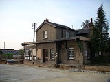
Stations listed northwest to south, in the 'up' direction- St. Ivesopened 17 August 1847, closed 5 October 1970.opened 17 August 1847, closed 5 October 1970. (or Longstanton)opened 17 August 1847, closed 5 October 1970.opened 17 August 1847, closed 5 October 1970.opened 17 August 1847, closed 5 October 1970.opened 1845
What remains
Much of the Cambridgeshire Guided Busway route has absorbed the old railway, with the only remaining section left untouched between the Fen Line and a (now-disused) level crossing over Milton Road. This alignment could, however, be utilised for an extension of the guided busway to meet the proposed Chesterton interchangeChesterton railway station
Chesterton railway station is a proposed railway station that would be located in the Cambridge suburb of Chesterton. The official proposal from Cambridgeshire County Council, which has the backing of the rail industry, is to locate the station at Chesterton Sidings on the Fen Line, which runs from...
; the construction of the new railway station at Chesterton is proposed for 2012/13.
Further reading
- Disused Stations, Subterranea Britannica
- The Busway, Cambridgeshire County Council
- CAST.IRON, a pressure group committed to reopening the railway