
California State Route 209
Encyclopedia
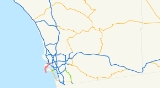
State Route 209 was a state highway
in the U.S. state
of California
, connecting Point Loma with the interchange
of I-5 and I-8 in San Diego.
and passed through Fort Rosecrans Military Reservation
and Fort Rosecrans National Cemetery
, then through the neighborhood of Point Loma via Catalina Boulevard, Cañon Street, and Rosecrans Street.
The Rosecrans Street portion of the highway follows the route of the historic La Playa Trail, the oldest European trail on the west coast, which connected the Spanish settlements in Old Town
and Mission San Diego de Alcala
with the ship loading and unloading area at La Playa.
in 2003. As signs get replaced on I-5, references to Route 209 are disappearing; however, Route 209 is still well marked on Rosecrans.
State highway
State highway, state road or state route can refer to one of three related concepts, two of them related to a state or provincial government in a country that is divided into states or provinces :#A...
in the U.S. state
U.S. state
A U.S. state is any one of the 50 federated states of the United States of America that share sovereignty with the federal government. Because of this shared sovereignty, an American is a citizen both of the federal entity and of his or her state of domicile. Four states use the official title of...
of California
California
California is a state located on the West Coast of the United States. It is by far the most populous U.S. state, and the third-largest by land area...
, connecting Point Loma with the interchange
Interchange (road)
In the field of road transport, an interchange is a road junction that typically uses grade separation, and one or more ramps, to permit traffic on at least one highway to pass through the junction without directly crossing any other traffic stream. It differs from a standard intersection, at which...
of I-5 and I-8 in San Diego.
Route description
The route began at the Cabrillo National MonumentCabrillo National Monument
Cabrillo National Monument is located at the southern tip of the Point Loma Peninsula in San Diego, California. It commemorates the landing of Juan Rodríguez Cabrillo at San Diego Bay on September 28, 1542. This event marked the first time that a European expedition had set foot on what later...
and passed through Fort Rosecrans Military Reservation
Naval Base Point Loma
Located in Point Loma, a neighborhood of San Diego, California, Naval Base Point Loma was established on 1 October 1998 when Navy facilities in the Point Loma area of San Diego were consolidated under Commander, Navy Region Southwest...
and Fort Rosecrans National Cemetery
Fort Rosecrans National Cemetery
Fort Rosecrans National Cemetery is situated in the city of San Diego, California, on the Fort Rosecrans Military Reservation. The cemetery is located approximately 10 miles west of downtown San Diego, overlooking the bay and the city...
, then through the neighborhood of Point Loma via Catalina Boulevard, Cañon Street, and Rosecrans Street.
The Rosecrans Street portion of the highway follows the route of the historic La Playa Trail, the oldest European trail on the west coast, which connected the Spanish settlements in Old Town
Old Town San Diego State Historic Park
Old Town San Diego State Historic Park, located in the Old Town neighborhood of San Diego, California, is a state protected historical park in San Diego. It commemorates the early days of the town of San Diego and includes many historic buildings from the period 1820 to 1870. The park was...
and Mission San Diego de Alcala
Mission San Diego de Alcalá
Mission Basilica San Diego de Alcalá, in San Diego, California, was the first Franciscan mission in the Las Californias Province of the Viceroyalty of New Spain. It was founded in 1769 by Spanish friar Junípero Serra in an area long inhabited by the Kumeyaay Indians...
with the ship loading and unloading area at La Playa.
History
This route was deletedDeleted state highways in California
Below is a list and summary of some of the deleted state highways as outlined by the legislature in 1964. For a complete list, see list of state highways in California and list of state highways in California ....
in 2003. As signs get replaced on I-5, references to Route 209 are disappearing; however, Route 209 is still well marked on Rosecrans.