
California's 39th State Senate district
Encyclopedia
California
's 39th State Senate
District is one of 40 Senate Districts. It is currently represented by Democrat
Christine Kehoe
of San Diego
.
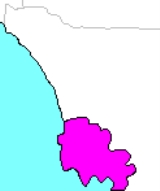
, is essentially an urban San Diego seat. The district includes most of the urban and inner suburban areas with significant Non-Hispanic White, Asian, and African-American populations.
The 39th District's southern end is downtown San Diego
, and it stretches northward to Del Mar
and eastward to Lemon Grove
. Parts of Casa de Oro-Mount Helix
, La Presa
, and Spring Valley are also in the district. However, 90% of the district's population is in the city of San Diego itself. Indeed, of San Diego's eight administrative regions, all of the Western and Northern Districts are in the 39th, including such neighborhoods as Old Town
, Hillcrest
, North Park
, Point Loma
, Clairemont
, Kearny Mesa
, Linda Vista
, Mission Valley
, Mission Beach
, Mission Bay, La Jolla
, Pacific Beach
, Ocean Beach
, and University Heights
.
The 2001 redistricting made the 39th Senate District a fairly safe Democratic district. As of 2006, 39.8% of registered voters were Democrats and 31.4% Republicans. However, most of the Decline to State
voters in the district, which includes UCSD, trend Democratic, and the district voted 54% for Kerry in the 2004 Presidential election.
California
California is a state located on the West Coast of the United States. It is by far the most populous U.S. state, and the third-largest by land area...
's 39th State Senate
California State Senate
The California State Senate is the upper house of the California State Legislature. There are 40 state senators. The state legislature meets in the California State Capitol in Sacramento. The Lieutenant Governor is the ex officio President of the Senate and may break a tied vote...
District is one of 40 Senate Districts. It is currently represented by Democrat
California Democratic Party
The California Democratic Party is the state branch of the Democratic Party in the state of California, headquartered in Sacramento. It is chaired by veteran Democratic politician and former United States Representative John L. Burton, who succeeded Art Torres in April 2009. It is the majority...
Christine Kehoe
Christine Kehoe
Christine T. Kehoe is an American politician from San Diego, California. A Democrat, she has served since 2004 as a member of the California State Senate representing the 39th district...
of San Diego
San Diego, California
San Diego is the eighth-largest city in the United States and second-largest city in California. The city is located on the coast of the Pacific Ocean in Southern California, immediately adjacent to the Mexican border. The birthplace of California, San Diego is known for its mild year-round...
.
District profile
The 39th District, located entirely in San Diego CountySan Diego County, California
San Diego County is a large county located in the southwestern corner of the US state of California. Hence, San Diego County is also located in the southwestern corner of the 48 contiguous United States. Its county seat and largest city is San Diego. Its population was about 2,813,835 in the 2000...
, is essentially an urban San Diego seat. The district includes most of the urban and inner suburban areas with significant Non-Hispanic White, Asian, and African-American populations.
The 39th District's southern end is downtown San Diego
San Diego, California
San Diego is the eighth-largest city in the United States and second-largest city in California. The city is located on the coast of the Pacific Ocean in Southern California, immediately adjacent to the Mexican border. The birthplace of California, San Diego is known for its mild year-round...
, and it stretches northward to Del Mar
Del Mar, California
Del Mar is an upscale beach town in San Diego County, California. The population was 4,161 at the 2010 census, down from 4,389 at the 2000 census. The San Diego County Fair is hosted on the Del Mar Fairgrounds every summer. Del Mar is Spanish for "of the sea" or "by the sea", because it is located...
and eastward to Lemon Grove
Lemon Grove, California
Lemon Grove is a city in San Diego County, California. The population was 25,320 at the 2010 census, up from 24,918 as of the 2000 census.-History:...
. Parts of Casa de Oro-Mount Helix
Casa de Oro-Mount Helix, California
Casa de Oro-Mount Helix is a census-designated place in San Diego County, California. The CDP encompasses several neighborhoods in unincorporated parts of the county near the cities of El Cajon and La Mesa as well as part of the unincorporated community of Spring Valley...
, La Presa
La Presa, California
La Presa is a census-designated place in San Diego County, California, United States. The population of was 34,169 at the 2010 census, up from 32,721 at the 2000 census...
, and Spring Valley are also in the district. However, 90% of the district's population is in the city of San Diego itself. Indeed, of San Diego's eight administrative regions, all of the Western and Northern Districts are in the 39th, including such neighborhoods as Old Town
Old Town San Diego State Historic Park
Old Town San Diego State Historic Park, located in the Old Town neighborhood of San Diego, California, is a state protected historical park in San Diego. It commemorates the early days of the town of San Diego and includes many historic buildings from the period 1820 to 1870. The park was...
, Hillcrest
Hillcrest, San Diego, California
Hillcrest is a neighborhood in San Diego, California northwest of Balboa Park and south of Mission Valley.Hillcrest is known for its tolerance, diversity, and locally-owned businesses, including restaurants, cafés, bars, clubs, trendy thrift-stores, and other independent specialty stores...
, North Park
North Park, San Diego, California
North Park is a neighborhood in San Diego, California, USA. It is situated to the northeast of Balboa Park, bounded on the north by the canyons overlooking Mission Valley, on the south by Switzer Canyon and the South Park neighborhood, on the east by Interstate 805 and City Heights, and on the...
, Point Loma
Point Loma, San Diego, California
Point Loma is a seaside community of San Diego, California. Geographically it is a hilly peninsula that is bordered on the west and south by the Pacific Ocean, the east by the San Diego Bay and Old Town and the north by the San Diego River...
, Clairemont
Clairemont, San Diego, California
Clairemont is a suburban neighborhood in northern San Diego.It includes the separate neighborhoods of North Clairemont, South Clairemont, Clairemont Mesa East and Clairemont Mesa West...
, Kearny Mesa
Kearny Mesa
-External links:***...
, Linda Vista
Linda Vista, San Diego, California
Linda Vista is a community in San Diego, California, United States. It is east of Mission Bay, north of Mission Valley, and south-east of Tecolote Canyon. It lies on a mesa overlooking Mission Valley...
, Mission Valley
Mission Valley, California
Mission Valley is a wide river valley trending east-west in San Diego, California, through which the San Diego River flows to the Pacific Ocean...
, Mission Beach
Mission Beach, San Diego, California
Mission Beach is a community built on a sandbar between the Pacific Ocean and Mission Bay. It is part of the city of San Diego, California.Mission Beach spans nearly two miles of ocean front. It is bounded by the San Diego River estuary on the south, Mission Bay Park on the east, and the community...
, Mission Bay, La Jolla
La Jolla, San Diego, California
La Jolla is an affluent, hilly seaside resort community, occupying of curving coastline along the Pacific Ocean in Southern California within the northern city limits of San Diego. La Jolla had the highest home prices in the nation in 2008 and 2009; the average price of a standardized...
, Pacific Beach
Pacific Beach, San Diego, California
Pacific Beach is a neighborhood of San Diego, bounded by La Jolla to the north, Mission Beach and Mission Bay to the south, Interstate 5 to the east and the Pacific Ocean to the west. While largely populated by young people, surfers, and college students, the population is becoming older, more...
, Ocean Beach
Ocean Beach, San Diego, California
Ocean Beach is a beachfront neighborhood of San Diego, California.-Geography:Ocean Beach is located in San Diego on the Southern California coast. It lies on the Pacific Ocean at the estuary of the San Diego River, at the western terminus of Interstate 8. It is approximately from Downtown San...
, and University Heights
University Heights, San Diego, California
University Heights is a neighborhood in Central San Diego, California centered around Park Boulevard and Adams Avenue. The area is filled with a number of restaurants, coffee shops, boutiques, and artist's studios primarily on Park Boulevard and Adams Avenue. Live entertainment can be found most...
.
- In the Central District, neighborhoods included in the 39th are GaslampGaslamp Quarter, San Diego, CaliforniaThe Gaslamp Quarter is the historic heart of San Diego, California. It is a 16½ block historical neighborhood in Downtown San Diego and is the center of downtown night life. The Quarter is home to many events and festivals, including Mardi Gras in the Gaslamp, Street Scene Music Festival, Taste of...
, East VillageEast Village, San Diego, CaliforniaEast Village is a neighborhood in San Diego, California. It is the largest district in the downtown of San Diego, and is located east of the Gaslamp Quarter and southeast of the Core district and Cortez Hill. East village has gone through extensive and rapid redevelopment, especially near Petco...
, Westfield Horton PlazaWestfield Horton PlazaHorton Plaza, officially Westfield Horton Plaza, is a five level outdoor shopping mall located in downtown San Diego and remarkable for its bright colors, architectural tricks and odd spatial rhythms. It stands on six and a half city blocks and is adjacent to the city's historic Gaslamp Quarter. ...
, MarinaMarina, San Diego, CaliforniaThe Marina district is a neighborhood in the southwest section of Downtown San Diego, California, U.S.-Geography:The district is bordered to the north by the Columbia district, bordered to east/south-east by the Gaslamp Quarter, and is bordered to the south-west by the San Diego Marina.This...
, Little ItalyLittle Italy, San Diego, CaliforniaLittle Italy is a somewhat hilly neighborhood in Downtown San Diego, California that was originally a predominately Italian fishing neighborhood...
, Harborview, Park West, Balboa Park, CortezCortez Hill, San Diego, CaliforniaCortez Hill is a neighborhood located in north-east Downtown San Diego, California.- Geography :Cortez Hill is located south of Bankers' Hill, north of the Core District, east of Little Italy and west by Balboa Park...
, South ParkSouth Park, San Diego, CaliforniaCentral portion of San Diego and neighborhood boundariesSouth Park is a neighborhood in San Diego, California located east of Balboa Park, and borne out of its southern neighbor Golden Hill. "South Park" is also north of Grant Hill and south of North Park, the boundary being Juniper Street...
and part of Barrio LoganLogan Heights, San Diego, CaliforniaLogan Heights is a neighborhood in central San Diego, California. It is bordered by Interstate 5 on the south and west, Interstate 15 on the east, and Imperial Avenue on the north.-History:... - In Mid-City: KensingtonKensington, San Diego, CaliforniaKensington is a neighborhood of San Diego, California. Its borders are defined by Interstate 15 to the west, Interstate 8 to the north, Fairmount Avenue to the east, and El Cajon Boulevard to the south. Its neighboring communities are Normal Heights to the west, Talmadge to the east, and City...
, College AreaCollege Area, San Diego, CaliforniaThe College Area is a neighborhood of the Mid-City region of San Diego, California.The College Area is dominated by San Diego State University , which was formerly San Diego State College and previous to that San Diego State Teachers College, which the area is still named after...
, Normal HeightsNormal Heights, San Diego, CaliforniaNormal Heights is a neighborhood of the mid-city region of San Diego, California. It is known for its affordable pubs, restaurants, coffee houses, antique shops, book shops, and burgeoning arts community.-History:...
, El CerritoEl Cerrito, San Diego, CaliforniaEl Cerrito, Spanish for "the little hill," is a neighborhood of the Mid-City region of San Diego, California. El Cerrito is a residential neighborhood, consisting mostly of suburban homes, with some commercial activity along the streets that define its borders....
, Oak ParkOak Park, San Diego, CaliforniaOak Park is a neighborhood of the Mid-City region of San Diego, California.-Geography:The neighborhood's borders are defined by Euclid Avenue to the west, Chollas Parkway/Streamview Drive/College Avenue to the north, and State Route 94 to the southeast....
, TalmadgeTalmadge, San Diego, CaliforniaTalmadge is a neighborhood of the mid-city region of San Diego, California. Its borders are defined by Fairmount Avenue to the West, Montezuma Road/Collwood Boulevard to the Northeast, and El Cajon Boulevard to the South....
, and part of City HeightsCity Heights, San Diego, CaliforniaCity Heights is a large community in the eastern part of San Diego, California, known for its ethnic diversity. Along the main streets one can find Hispanic, White American, East African, African American, Indian, Middle Eastern, and Southeast Asian businesses... - In Southeastern: EncantoEncanto, San Diego, CaliforniaEncanto is a hilly neighborhood located in the southeastern part of San Diego, California. The neighborhood of Encanto is split into two sections, North Encanto , and South Encanto ....
, Skyline, most of Paradise HillsParadise Hills, San Diego, CaliforniaParadise Hills is a neighborhood in the southeastern area of the city of San Diego, California. It is an outlying neighborhood adjacent to the independent city of National City and the unincorporated communities of Lincoln Acres and certain portions of Bonita....
, Emerald Lake Hills, and Valencia Park - In Eastern: Serra MesaSerra Mesa, San Diego, CaliforniaSerra Mesa is a community in San Diego, California. It is located between Interstate 805 and Interstate 15, north of Friars Road and south of Aero Drive. Serra Mesa is named for Father Junípero Serra, a Majorcan Franciscan friar who founded the Mission San Diego de Alcalá...
and Allied Gardens, and parts of NavajoNavajo, San Diego, CaliforniaNavajo is a hilly community in the eastern part of San Diego, California. It is a designated planning area for the city of San Diego. It includes the neighborhoods of Del Cerro, Grantville, San Carlos, and Allied Gardens.The area encompases approximately...
and TierrasantaTierrasanta, San Diego, CaliforniaTierrasanta, Spanish for "holy land," is a community within the city of San Diego, California. The symbol of Tierrasanta is an encircled Conquistador cross, similar to the Montserrat Cross of Barcelona, Spain, though it holds no religious meaning... - In Northeastern: MiramarMiramar, San Diego, CaliforniaMiramar is a neighborhood in the northern part of the city of San Diego, California, USA. It includes residential areas and commercial and light industrial districts....
, Mira MesaMira Mesa, San Diego, CaliforniaMira Mesa is a large suburb that is part of the city of San Diego, California.Mira Mesa is bordered by Interstate 15 to the east, Interstate 805 to the west, the Los Peñasquitos Canyon to the north and Marine Corps Air Station Miramar, to the south. The west end of Mira Mesa is a business and...
, and Sorrento ValleySorrento Valley, San Diego, CaliforniaSorrento Valley is a neighborhood of San Diego, California. It is located about 15 mi north of Downtown San Diego and its main airport, Lindbergh Field...
, and portions of Rancho PeñasquitosRancho Penasquitos, San Diego, CaliforniaRancho Peñasquitos is a community in the northeastern part of the city of San Diego, California. It is named after the first Spanish Land Grant in the County - Rancho de Los Penasquitos. Peñasquitos means little cliffs in Spanish. It abuts Los Penasquitos canyon preserve - an open space... - The Southern District is the only region not to be partially in the 39th.
The 2001 redistricting made the 39th Senate District a fairly safe Democratic district. As of 2006, 39.8% of registered voters were Democrats and 31.4% Republicans. However, most of the Decline to State
Decline To State
Decline to State is an affiliation designation on the California voter registration form that allows voters to register to vote without choosing a party affiliation. It is similar to what in other states would be called declaring oneself as an independent...
voters in the district, which includes UCSD, trend Democratic, and the district voted 54% for Kerry in the 2004 Presidential election.