
Clairemont, San Diego, California
Encyclopedia
Clairemont is a suburban neighborhood in northern San Diego.
It includes the separate neighborhoods of North Clairemont, South Clairemont, Clairemont Mesa East and Clairemont Mesa West. It is bordered by State Route 52
in the north, Interstate 805 in the east, Interstate 5 in the west, and the neighborhood of Linda Vista
on the south.
The neighborhood was first developed in the post-war building boom of the 1950s.
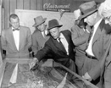
 In 1950, Carlos Tavares and Lou Burgener developed what became San Diego's largest post-war subdivision. Originally dubbed, "The Village Within a City", people started living in Clairemont in May, 1951.
Clairemont's design represented a new concept in community living because it did not incorporate the traditional grid system of uniform blocks and streets. Instead, winding streets and scenic view lots took advantage of the canyons and bluffs overlooking Mission Bay. The first homes, built by Burgener and Tavares Construction Company, had highly customized floor plans.
The developers assembled the necessary acreage to develop Clairemont from three primary land holdings: the Peavey Cattle Ranch, Mission Bay Heights (owned by the Hazard Family), & Tecolote Heights (owned by Jack & Dan Danciger).
Before any homes were built in the new development, Tavares & Burgener invested $125,000 in off-street improvements including sewers, water, and access roads; this was necessary because the proposed development was not adjacent to any developed areas. The original Subdivision map that used the name “Clairemont” for the first time was approved and recorded by the County of San Diego on October 16, 1950. The map was named “Clairemont Unit #1, Map #2725”. This is the area in Clairemont that includes Deerpark Dr., Burgener Blvd., and Grandview St. from Field St. to Jellett St. According to Burgener, "Between 1952 & 1954, seven homes were constructed a day". It is also noted that Clairemont was the largest development of its kind in the country.
Due to the road structure, Clairemont was laid out in a Northern direction from which "North Clairemont" evolved. However, Clairemont began to grow in an eastern direction which is now the political distinction of the area. Clairemont's western side has a majority of family homes created by Pardee homes. There are several apartments in this area but not nearly as many in the eastern side. The eastern side has rows of apartments and duplexes scattered around the area east of Genesee Avenue.
Local architects, Harold Abrams, Benson Eschenbach and Richard George Wheeler, designed 20 floor plans for the first development of 500 homes. Built in South Clairemont, these deluxe houses ranged in price from $13,000 to $20,000, featured spacious floorplans, large view windows, fireplaces, tiled bathrooms, paneling and the then latest kitchen built-ins. After the WWII years of housing shortages, these homes sold quickly. Many of these homes now have updated more open floor plans and 2nd story additions as owners have remodeled the older designs. Many homes have upgraded backyards and patios which take advantage of the ocean breezes which come from nearby Mission Bay. Since much of Clairemont has no Homeowners Association
s to enforce code
in residential areas, residents often park RV's or boats on the side of the property.
Within a few years, several thousand houses had been constructed, including single family homes, duplexes and apartments. Since Clairemont was somewhat removed from the city proper, commercial business and retail shopping, schools, libraries and other city amenities were designed into the overall plan. Although the concept of suburban living is commonplace today, this approach was considered novel and Tavares' vision for Clairemont had far-reaching implications for San Diego as it stretched the city limits outward and began the now familiar pattern of migration from city to suburb.
Today, the only land that remains vacant in Clairemont (once a vacant prairie) is San Clemente Canyon & Tecolote Canyon. Local residents rallied to save both canyons from development and were designated parks in the 1970s.
A small airport runway (Clairemont Drive) existed from Iroquois Street to just past Dakota Drive in the early aerial photos seen of the area. Aeronautical charts of 1948 and 1951 show it was named San Diego Airpark with an unpaved runway length of 2900 feet (883.9 m). Baker Street was the only access from Old Highway 101 (Morena Boulevard) up to the new subdivisions. The 1950s and early 1960s added many new shopping centers and access roads to crisscross the area. Many of the original shopping centers have been redeveloped.
It includes the separate neighborhoods of North Clairemont, South Clairemont, Clairemont Mesa East and Clairemont Mesa West. It is bordered by State Route 52
California State Route 52
State Route 52 is a state highway in the U.S. state of California in San Diego County, that extends from La Jolla Parkway at Interstate 5 in La Jolla to Route 67 in Santee. Route 52 is a freeway for its entire length...
in the north, Interstate 805 in the east, Interstate 5 in the west, and the neighborhood of Linda Vista
Linda Vista, San Diego, California
Linda Vista is a community in San Diego, California, United States. It is east of Mission Bay, north of Mission Valley, and south-east of Tecolote Canyon. It lies on a mesa overlooking Mission Valley...
on the south.
The neighborhood was first developed in the post-war building boom of the 1950s.
Etymology
Developers Lou Burgener and Carlos Tavares called their community Clairemont after Tavares' wife, Marjorie Claire.History
Clairemont's design represented a new concept in community living because it did not incorporate the traditional grid system of uniform blocks and streets. Instead, winding streets and scenic view lots took advantage of the canyons and bluffs overlooking Mission Bay. The first homes, built by Burgener and Tavares Construction Company, had highly customized floor plans.
The developers assembled the necessary acreage to develop Clairemont from three primary land holdings: the Peavey Cattle Ranch, Mission Bay Heights (owned by the Hazard Family), & Tecolote Heights (owned by Jack & Dan Danciger).
Before any homes were built in the new development, Tavares & Burgener invested $125,000 in off-street improvements including sewers, water, and access roads; this was necessary because the proposed development was not adjacent to any developed areas. The original Subdivision map that used the name “Clairemont” for the first time was approved and recorded by the County of San Diego on October 16, 1950. The map was named “Clairemont Unit #1, Map #2725”. This is the area in Clairemont that includes Deerpark Dr., Burgener Blvd., and Grandview St. from Field St. to Jellett St. According to Burgener, "Between 1952 & 1954, seven homes were constructed a day". It is also noted that Clairemont was the largest development of its kind in the country.
Due to the road structure, Clairemont was laid out in a Northern direction from which "North Clairemont" evolved. However, Clairemont began to grow in an eastern direction which is now the political distinction of the area. Clairemont's western side has a majority of family homes created by Pardee homes. There are several apartments in this area but not nearly as many in the eastern side. The eastern side has rows of apartments and duplexes scattered around the area east of Genesee Avenue.
Local architects, Harold Abrams, Benson Eschenbach and Richard George Wheeler, designed 20 floor plans for the first development of 500 homes. Built in South Clairemont, these deluxe houses ranged in price from $13,000 to $20,000, featured spacious floorplans, large view windows, fireplaces, tiled bathrooms, paneling and the then latest kitchen built-ins. After the WWII years of housing shortages, these homes sold quickly. Many of these homes now have updated more open floor plans and 2nd story additions as owners have remodeled the older designs. Many homes have upgraded backyards and patios which take advantage of the ocean breezes which come from nearby Mission Bay. Since much of Clairemont has no Homeowners Association
Homeowners association
A homeowner association is a corporation formed by a real estate developer for the purpose of marketing, managing, and selling of homes and lots in a residential subdivision...
s to enforce code
Code Enforcement
Code enforcement, sometimes encompassing law enforcement, is the act of enforcing a set of rules, principles, or laws and insuring observance of a system of norms or customs. An authority usually enforces a civil code, a set of rules, or a body of laws and compel those subject to their authority...
in residential areas, residents often park RV's or boats on the side of the property.
Within a few years, several thousand houses had been constructed, including single family homes, duplexes and apartments. Since Clairemont was somewhat removed from the city proper, commercial business and retail shopping, schools, libraries and other city amenities were designed into the overall plan. Although the concept of suburban living is commonplace today, this approach was considered novel and Tavares' vision for Clairemont had far-reaching implications for San Diego as it stretched the city limits outward and began the now familiar pattern of migration from city to suburb.
Today, the only land that remains vacant in Clairemont (once a vacant prairie) is San Clemente Canyon & Tecolote Canyon. Local residents rallied to save both canyons from development and were designated parks in the 1970s.
A small airport runway (Clairemont Drive) existed from Iroquois Street to just past Dakota Drive in the early aerial photos seen of the area. Aeronautical charts of 1948 and 1951 show it was named San Diego Airpark with an unpaved runway length of 2900 feet (883.9 m). Baker Street was the only access from Old Highway 101 (Morena Boulevard) up to the new subdivisions. The 1950s and early 1960s added many new shopping centers and access roads to crisscross the area. Many of the original shopping centers have been redeveloped.
Geography
Tecolote Canyon Golf Course is in the bottom of the southern canyon area. There are streams and trails that extend into finger canyons in the area.Notable residents
- Kendra WilkinsonKendra WilkinsonKendra Leigh Baskett , professionally known by her maiden name, is an American television personality and glamour model...
, model and television personality - Adam GnadeAdam GnadeAdam Gnade is a San Diego, California-born American musician and author currently living on a farm in rural Kansas. In his bio he defines his music as "talking-songs", which he describes as mixing the spoken vocals of talking blues songs with country music, Appalachian folk, noise, psychedelic...
, novelist - Phil KonstantinPhil KonstantinPhil Konstantin is American, and also a citizen of the Cherokee Nation. While his legal name is Morris Phillip Konstantin, he has always gone by the name of Phil Konstantin. He was one of the computer operators who ran the IBM 360, model 75J computers at NASA during the Apollo 16 and Apollo 17...
, television personality, author
Education
- Marston Jr. High
- James Madison High SchoolJames Madison High School (California)For schools with a similar name, see Madison High School.James Madison High School is a public high school in San Diego, California. It is part of the San Diego Unified School District. Madison's campus opened in 1962...
- Clairemont High SchoolClairemont High SchoolClairemont High School is a public high school located in the Clairemont neighborhood of San Diego, California. It is part of the San Diego Unified School District. The campus is situated close to the intersection of Balboa Ave and Clairemont Drive. There are approximately 1,350 students and 87...
- Islamic School of San Diego
- Health Sciences High and Middle College School
- Lindbergh/Schweitzer Elementary School
- The Child's Primary School
- Maria Montessori Schools
- CPMA Middle School
- Innovation Middle School
- San Diego Mesa CollegeSan Diego Mesa CollegeSan Diego Mesa College is a public, two-year community college perched on a mesa in the Clairemont neighborhood of San Diego, California in the United States. It is the largest community college in the city of San Diego and part of the San Diego Community College District along with San Diego City...