
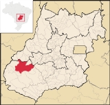
Caiapônia
Encyclopedia
Town
A town is a human settlement larger than a village but smaller than a city. The size a settlement must be in order to be called a "town" varies considerably in different parts of the world, so that, for example, many American "small towns" seem to British people to be no more than villages, while...
and municipality
Municipality
A municipality is essentially an urban administrative division having corporate status and usually powers of self-government. It can also be used to mean the governing body of a municipality. A municipality is a general-purpose administrative subdivision, as opposed to a special-purpose district...
in south-central Goiás
Goiás
Goiás is a state of Brazil, located in the central part of the country. The name Goiás comes from the name of an indigenous community...
state, Brazil
Brazil
Brazil , officially the Federative Republic of Brazil , is the largest country in South America. It is the world's fifth largest country, both by geographical area and by population with over 192 million people...
. It has the third largest cattle herd in the state and is a major producer of grains. The town is also known as Torres Do Rio Bonito or just Rio Bonito.
Geography
Known as the city of the Thousand Waterfalls, Caiapônia offers several options for the tourist. It is located 334 kilometers southwest of GoiâniaGoiânia
-Climate:The city has a tropical wet and dry climate with an average temperature of . There's a wet season, from October to April, and a dry one, from May to September. Annual rainfall is around 1,520 mm....
following GO-221. The main highways of access are GO-060 / Trindade, Goiás
Trindade, Goiás
Trindade is a city and municipality in Goiás state, Brazil. It is famous for the religious celebrations held there in July and is now the third most important pilgrimage site in Brazil....
/ Nazário
Nazário
Nazário is a small town and municipality in eastern Goiás state, Brazil.-Location:Nazário is located 74 km. west of the state capital, Goiânia a few kilometers west of the Rio dos Bois, a major tributary of the Paranaíba River. The regional center, Anicuns, is 21 km to the northwest...
/ Firminópolis
Firminópolis
Firminópolis is a small town and municipality in eastern Goiás state, Brazil.-Location and connections:*Distance to São Luís de Montes Belos: 9 km....
/ Israelândia
Israelândia
Israelândia is a small town and municipality in eastern Goiás state, Brazil.-Location:Israelândia is located in the Iporá Microregion, 28 km. northeast of regional center Iporá. State capital Goiânia is 199 km. to the east...
/ Iporá
Iporá
Iporá is a small city and municipality in west-central Goiás state, Brazil. The population was 31,060 in a total area of 1,026.4 km² . It is known as the City of the Clear Waters because of its many streams and rivers.-Location:...
/ GO-221 /. It is part of the Sudoeste de Goiás Microregion and has municipal boundaries with Baliza
Baliza
Baliza is a small town and municipality in eastern Goiás state, Brazil. The population was 3,299 in a total area of 1,783.00 km².-Location:...
, Bom Jardim de Goiás
Bom Jardim de Goiás
Bom Jardim de Goiás is a small town and municipality in western Goiás state, Brazil. The population was 8,372 in a total area of 1,557 km². Bom Jardim is a large producer of cattle.-Location:...
, Montividiu
Montividiu
thumb|right|250px|Coordinates: Montividiu is a small town and municipality in eastern Goiás state, Brazil. Montividiu is a large producer of soybeans and corn.-Location and Neighboring Municipalities:...
, Rio Verde
Rio Verde
Rio Verde can mean the following:-Brazil:* Rio Verde, Goiás* Lucas do Rio Verde* Conceição do Rio Verde* Rio Verde de Mato Grosso-Brazil:29 rivers including:* Verde River...
, Ivolândia
Ivolândia
Ivolândia is a small town and municipality in eastern Goiás state, Brazil. The population was 2,718 in a total area of 1,262.8 km² .-Location:*Distance to regional center : 56 km....
, Palestina de Goiás
Palestina de Goiás
Palestina de Goiás is a small town and municipality in eastern Goiás state, Brazil.-Location:Palestina is located in the Sudoeste de Goiás Microregion between the Rio Bonito and the Rio Caiapó. There are paved road connections linking the town to Jataí in the south and to Iporá in the northeast...
, Doverlândia
Doverlândia
Doverlândia is a small city and municipality in eastern Goiás state, Brazil. It is a large producer of cattle and soybeans.-Location and Highway Connections:...
and Jataí
Jataí
Jataí is a municipality in southern Goiás state, Brazil. Its population was 88,048 in a total area of 7,174.2 km². Jataí is a major producer of agricultural products, including soybeans, rice, and corn. It has the largest herd of cattle in the state and is a large producer of poultry and...
.
Districts, Villages, and Hamlets
- Villages: Boa Vista and Planalto Verde.
Demographics
- Population density in 2007: 1.82 inhab/km²
- Population growth rate 1996/2007: 0.93% 1996/2007
- Total population in 2007: 15,747
- Total population in 1980: 28,632
- Urban population in 2007: 11,493
- Rural population in 2007: 4,254 (the rural population was 15,677 in 1980)
- Population change: the population decreased around 13,000 since 1980.
The Economy
The economy is based on cattle-raising, with the third largest herd in the state of GoiásGoiás
Goiás is a state of Brazil, located in the central part of the country. The name Goiás comes from the name of an indigenous community...
(415,000 head in 2006) and large plantations of corn, soybeans, and rice. Milk production is also very important.
Economic Data (2007)
- Industrial establishments: 18
- Financial Institutions in 2007: Banco do Brasil S.A., Banco Itaú S.A.
- Retail establishments in 2007: 159 (Sepin 2007)
Motor vehicles
- Automobiles: 894 (2007)
- Pickup trucks: 364
- Number of inhabitants per motor vehicle: 11 (IBGE 2007)
Main agricultural products in ha.(2006)
- cotton: 4,000
- pineapple: 45
- rice: 4,000
- banana: 10
- coffee: 6
- sugarcane: 35
- beans: 1,450
- sunflower: 200
- corn: 15,000
- soybeans: 55,000
- sorghum: 2,600 (Sepin 2006)
Farm Data (2006)in ha.
- Number of farms: 1,275
- Total area: 560,749
- Area of permanent crops: 3,316
- Area of perennial crops: 33,761
- Area of natural pasture: 366,896
- Persons dependent on farming: 3,450
Health and Education
The health sector was represented by 03 hospitals with 48 beds (2007). In 2006 there were 18 schools with 4,125 students. There was no higher education as of 2007.- Infant mortality in 2000: 18.25
- Literacy rate: 82.4 (2000)
- Ranking on the Municipal Human Development IndexHuman Development IndexThe Human Development Index is a composite statistic used to rank countries by level of "human development" and separate "very high human development", "high human development", "medium human development", and "low human development" countries...
: 0.735 - State ranking: 127 (out of 242 municipalities)
- National ranking: 2,310 (out of 5,507 municipalities)
Tourism
The municipality has several rivers: Caiapó, Bonito, Paraíso, Peixe, Piranhas, Verdão, Claro and Doce. There are also innumerable waterfalls: Torre, Freira, Gigante Adormedido, Cachoeira do Pantano, Cachoeira do Vale, Cachoeira do Salomão, and Cachoeira da Abóbora among others. Cachoeira do Vale is located 12 kilometres from the city. It has a lake of cristaline waters, perfect for swimming. Cachoeira de São Domingos is formed by the Piranhas River and has a fall of 40 meters. The highest waterfall, though, is Cachoeira do Salomão with a fall of 80 meters. Its access is difficult but once there the tourist can see transparent waters protected by thick tropical vegetation, containing orchids of several colors.History
Caiapônia derives its name from the Caiapó Indians who fought wars with settlers until the end of the nineteenth century. The first church, Espírito Santo, was built in 1845 and by 1850 the settlement had several houses and was known as Torres do Rio Bonito. In 1855 its status as "povoado" passed to "distrito" and it became part of the municipality of Rio VerdeRio Verde, Goiás
Rio Verde is a city and municipality in the Brazilian state of Goiás. It is a fast-growing center and is the largest producer of grains in the state.-Location:...
. In 1871 Torres do Rio Bonito was raised to municipal status, the name being shortened to Rio Bonito in 1911. Finally in 1943 the name was changed to Caiapônia, to honor the Indians who had lived in the area. Source: Sepin
See also
- List of municipalities in Goiás
- Microregions of Goiás