

Cabo Polonio
Encyclopedia
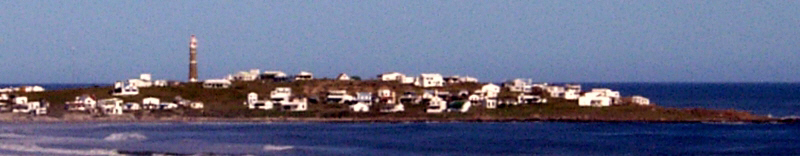
Cabo Polonio is a caserío (hamlet) located in the eastern coast of Uruguay
in the Rocha Department
.
Cabo Polonio has no roads leading to it and is located about 7 km from the main highway. It is accessible by walking through the dunes or by 4x4 vehicles. The region has no electricity or running water for the few hundred houses of this town, and wind power and a few generators are used to power some of the posadas and grocery store. There is a lighthouse that gets power from the national grid. Residents obtain water from nearby water wells or collecting rain water.
Source: Instituto Nacional de Estadística de Uruguay
This village principal attraction is the Atlantic beach, with water and sand, a natural reserve of sea lion
s and one of the area's few mobile sand dunes, in which the sand is blown by the wind and moves around the sandy places and the dunes actually change their position. The village land is shared by the Uruguayan government and private owners. The government has included the area into the SNAP (Sistema Nacional de Áreas Protegidas) National System of Protected Areas.
Uruguay
Uruguay ,officially the Oriental Republic of Uruguay,sometimes the Eastern Republic of Uruguay; ) is a country in the southeastern part of South America. It is home to some 3.5 million people, of whom 1.8 million live in the capital Montevideo and its metropolitan area...
in the Rocha Department
Rocha Department
Rocha is a department in the east of Uruguay. It has natural beauties like Cabo Polonio, Valizas, Santa Teresa. Rocha is well known for its beach towns which swell during the summer holidays...
.
Cabo Polonio has no roads leading to it and is located about 7 km from the main highway. It is accessible by walking through the dunes or by 4x4 vehicles. The region has no electricity or running water for the few hundred houses of this town, and wind power and a few generators are used to power some of the posadas and grocery store. There is a lighthouse that gets power from the national grid. Residents obtain water from nearby water wells or collecting rain water.
Population
According to the 2004 census, it had a population of 72 inhabitants.| Year | Population |
|---|---|
| 1963 | 58 |
| 1975 | 36 |
| 1985 | 53 |
| 1996 | 103 |
| 2004 | 72 |
Source: Instituto Nacional de Estadística de Uruguay
Features
Cabo Polonio sits on the tip of a moon-sliver shaped peninsula that extends into the Atlantic Ocean. The back side experiences relentless powerful waves, and on the inside of the moon-shaped area, the water comes calmly to shore. At the top end, a lighthouse stands over boulders tumbling into the sea. Two small, rocky islands dot the coast nearby.This village principal attraction is the Atlantic beach, with water and sand, a natural reserve of sea lion
Sea Lion
Sea lions are pinnipeds characterized by external ear-flaps, long fore-flippers, the ability to walk on all fours, and short thick hair. Together with the fur seal, they comprise the family Otariidae, or eared seals. There are six extant and one extinct species in five genera...
s and one of the area's few mobile sand dunes, in which the sand is blown by the wind and moves around the sandy places and the dunes actually change their position. The village land is shared by the Uruguayan government and private owners. The government has included the area into the SNAP (Sistema Nacional de Áreas Protegidas) National System of Protected Areas.
External links
- Cabo Polonio Website
- Portal de Cabo Polonio english version
- Systema Nacional de Áreas Protegidas de Uruguay, Cabo Polonio
- Uruguay, between river and ocean
- the perfect, sleepy beach town
- INE map of Cabo Polonio