

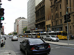
Buses in Adelaide
Encyclopedia
South Australia
South Australia is a state of Australia in the southern central part of the country. It covers some of the most arid parts of the continent; with a total land area of , it is the fourth largest of Australia's six states and two territories.South Australia shares borders with all of the mainland...
n capital's public transport
Public transport
Public transport is a shared passenger transportation service which is available for use by the general public, as distinct from modes such as taxicab, car pooling or hired buses which are not shared by strangers without private arrangement.Public transport modes include buses, trolleybuses, trams...
system, the Adelaide Metro
Adelaide Metro
Adelaide Metro is the public transport system of the South Australian capital of Adelaide and the brand name of the Public Transport Division of the Department of Planning, Transport and Infrastructure. It is an intermodal system with services provided by bus, tram or commuter rail throughout the...
. A large fleet of diesel and natural gas powered buses operate services which typically terminate in the city-centre or at a suburban interchange. Buses get priority on many roads and intersections, with dedicated bus lane
Bus lane
A bus lane or bus only lane is a lane restricted to buses, and generally used to speed up public transport that would be otherwise held up by traffic congestion...
s and 'B'-light bus only phases at many traffic lights. According to the 2008 State Budget, all buses that entered service during the 1980s will be withdrawn within the next 5 years and replaced with new buses.
Operators
The Adelaide Metro buses are operated by:- Torrens TransitTorrens TransitTorrens Transit is a privately owned public transport company which operates a bus service in the South Australian capital of Adelaide. It is part of Transit Systems Australia, which also operates Swan Transit....
- East-West and City Free - SouthLinkSouthLinkSouthLink is a private public transport company that provides a bus service to outer southern and outer northern Adelaide, Australia. Australian Transit Enterprises , a joint venture between Hornibrook Bus Lines and Grenda Corporation, is SouthLink's parent company, and is also provides bus...
– Outer North and Outer South - TransitplusTransitplusTransitplus is a privately-owned public transport company which operates a bus service from the South Australian capital Adelaide, to the Adelaide Hills, mainly Mount Barker area. It is part of the Adelaide Metro network. It is a joint venture between TransAdelaide, which also operates the train...
- Adelaide Hills and Regional - Light City Buses - O-Bahn, Inner North and Inner South
Go Zones
Many arterial roads leading towards the CBD have several routes servicing them, allowing for high frequency "Go-Zones", with a maximum wait of 15 minutes on weekdays. These are:
|
|
|
There is a Mega Go Zone on the O-Bahn which has a maximum 10 minute wait on weekdays and 15 minutes on weekends. Go Zones branching off the O-Bahn have a 15 minute maximum wait. These include:
- O-Bahn BuswayO-Bahn BuswayThe Adelaide O-Bahn Busway is a guided busway located in Adelaide, South Australia. The O-Bahn – from the Latin omnibus and the German bahn – was conceived by Daimler-Benz to enable buses to avoid traffic congestion by sharing tram tunnels in the German city of Essen.The route was introduced in...
to:- Para Hills via Nelson Road and Kelly Road
- Golden Grove via Golden Grove Road
- Tea Tree Gully via Smart Road
- Surrey Downs via Hancock Road
- Hope Valley via Lower North East Road
Roam Zones
The Roam Zone concept began operation in the Hallett Cove, Sheidow Park and Trott Park area in September 2001. At specified times passengers can be dropped off or picked up away from bus stops, taking them to their door (or as near as the bus could get). Having done this, the roaming bus returns to its scheduled route. Roam Zones have bright blue bus stops located throughout. Adelaide Metro now features six Roam Zones:- Golden GroveGolden Grove, South AustraliaGolden Grove is an outer north-eastern suburb of Adelaide, South Australia and is within the City of Tea Tree Gully local government area. It is adjacent to Wynn Vale, Surrey Downs, Greenwith, Yatala Vale, Fairview Park, and Salisbury East.- History :...
(weekdays 10.00am-3.00pm and from 7.40pm; weekends from 7.00pm) - Holden Hill (daily from 7.30pm)
- Hallett Cove, Sheidow Park and Trott Park (daily from 7.00pm)
- Aberfoyle Park (weekdays 3.30pm-7.00pm)
- Athelstone (daily from 7:30pm)
- Davoren Park, SmithfieldSmithfieldSmithfield is the name of several places:In Australia:* Smithfield, New South Wales* Smithfield, Queensland, near Cairns* Smithfield, South Australia, a northern suburb of Adelaide**Smithfield railway station, Adelaide...
and Andrews Farm (daily from 7.00pm)
TransitLink services
TransitLink bus services are limited stop express bus routes, operating to and from the city on weekdays. TransitLink services are:- T721 - Noarlunga CentreNoarlunga Centre InterchangeNoarlunga Centre Interchange is the terminus of the Noarlunga Centre line, a part of the suburban railway system in Adelaide, South Australia....
to City via South RoadSouth Road, AdelaideSouth Road is a major north–south conduit in Adelaide, South Australia. Also known as Main South Road, it is Adelaide's most important arterial road.- Route :... - T721X - Noarlunga CentreNoarlunga Centre InterchangeNoarlunga Centre Interchange is the terminus of the Noarlunga Centre line, a part of the suburban railway system in Adelaide, South Australia....
to City via Southern ExpresswaySouthern ExpresswayThe Southern Expressway is the world's longest reversible one way freeway. Originally proposed as 'Noarlunga Freeway', it was built as a corridor to relieve heavy traffic from the major arterial, Main South Road, in Adelaide's south. The expressway was built in two stages — the first...
and South Road - T722 - SeafordSeaford, South AustraliaSeaford is a metropolitan suburb of Adelaide, South Australia. It lies within the City of Onkaparinga.-History:Seaford, a coastal suburb to the near south of Port Noarlunga, was set out on Sections 334 and 340, Hundred of Noarlunga, in 1954 by the Wakefield Land Company Pty Ltd...
to City via WoodcroftWoodcroft, South AustraliaWoodcroft is a metropolitan suburb of Adelaide, South Australia, located 20 km south of the Central Business District of Adelaide. It is bordered to the north by Reynell Road, to the south by Bains Road, to the west by Panalatinga Road and by the Hills Face Zone to the east.- History :Originally...
and South Road - T748 - Seaford RiseSeaford Rise, South AustraliaSeaford Rise is a metropolitan suburb of Adelaide, South Australia. It lies within the Seaford Rise is a metropolitan suburb of [[Adelaide, South Australia]]. It lies within the...
to Noarlunga CentreNoarlunga Centre InterchangeNoarlunga Centre Interchange is the terminus of the Noarlunga Centre line, a part of the suburban railway system in Adelaide, South Australia....
via Southern Expressway - T840 - Mount BarkerMount Barker, South AustraliaMount Barker is an expanding city, home to 10 258 residents that is 33 kilometres up the South Eastern Freeway, east of Adelaide, in South Australia. It is the seat of the District Council of Mount Barker, is the largest town in the Adelaide Hills, and is one of the fastest growing areas in the...
to City via South Eastern FreewaySouth Eastern FreewayThe South Eastern Freeway is a 66 kilometre four-lane divided carriageway road in South Australia linking the Adelaide-Crafers Highway to the Princes Highway at the Swanport Bridge, a one kilometre long bridge over the River Murray, near Murray Bridge... - T842 - NairneNairne, South AustraliaNairne is a small township in South Australia and was founded by Matthew Smillie in 1839. Nairne is about 7 km from Mount Barker, in the federal Division of Mayo and in the state electoral district of Kavel...
to City via Mount BarkerMount Barker, South AustraliaMount Barker is an expanding city, home to 10 258 residents that is 33 kilometres up the South Eastern Freeway, east of Adelaide, in South Australia. It is the seat of the District Council of Mount Barker, is the largest town in the Adelaide Hills, and is one of the fastest growing areas in the...
and South Eastern Freeway - T863 - AldgateAldgate, South AustraliaAldgate is a South Australian town located 21 kilometres south-east of Adelaide, in the Adelaide Hills.The town of Aldgate was supposedly named in 1882 after the local hotel the Aldgate Pump, which was named by Richard D. Hawkins, who had additionally opened the nearby Crafers Inn...
to City via StirlingStirling, South AustraliaStirling is a town located in the Adelaide Hills. It is administered by the Adelaide Hills Council. Its population is about 2500, though the town has largely merged with neighbouring townships such as Crafers and Aldgate. The towns closely surrounding it are: Aldgate, Crafers, Bridgewater and...
and South Eastern Freeway - G40 - Golden Grove Village to City and Flinders UniversityFlinders UniversityFlinders University, , is a public university in Adelaide, South Australia. Founded in 1966, it was named in honour of navigator Matthew Flinders, who explored and surveyed the South Australian coastline in the early 19th century.The university has established a reputation as a leading research...
via O-BahnO-Bahn BuswayThe Adelaide O-Bahn Busway is a guided busway located in Adelaide, South Australia. The O-Bahn – from the Latin omnibus and the German bahn – was conceived by Daimler-Benz to enable buses to avoid traffic congestion by sharing tram tunnels in the German city of Essen.The route was introduced in...
and Goodwood RoadGoodwood Road, AdelaideGoodwood Road is a major north-south arterial road, approximately 10 kilometres long, in Adelaide, South Australia. It runs between the Adelaide city centre and the suburbs of Pasadena and Panorama, and has a speed limit of .... - M44 - Golden Grove Village to Westfield MarionWestfield MarionWestfield Marion is the largest shopping complex in Adelaide, South Australia. The centre, its management and all tenant addresses are located in the suburb of Oaklands Park...
via O-Bahn, the City and Marion Road - C1 - Elizabeth Station to City via Golden Grove Village, Tea Tree Plaza and O-Bahn
- C2 - GreenwithGreenwith, South AustraliaGreenwith is an outer-north-eastern suburb of Adelaide, the capital city of South Australia, and is within the City of Tea Tree Gully local government area. It is adjacent to Golden Grove and Salisbury Heights...
to City via Golden Grove Village, Tea Tree Plaza and O-Bahn
JetBus services
JetBus services were introduced in August 2005. These are direct daily routes that link Adelaide Airport with the city and other key destinations. JetBus routes are: City to GlenelgGlenelg, South Australia
Glenelg is a popular beach-side suburb of the South Australian capital of Adelaide. Located on the shore of Holdfast Bay in Gulf St Vincent, it has become a popular tourist destination due to its beach and many attractions, home to several hotels and dozens of restaurants.Established in 1836, it is...
via Adelaide Airport and Harbour Town.
} Shortworking to Adelaide Airport City to West Beach
West Beach, South Australia
West Beach is a seaside suburb of Adelaide, South Australia. It is located in both the City of Charles Sturt and the City of West Torrens.-History:...
via Adelaide Airport and Harbour Town.
} Shortworking to Adelaide Airport Westfield West Lakes
Westfield West Lakes
Westfield West Lakes is a large South Australian shopping centre in the north-western Adelaide suburb of West Lakes, developed in the late 1970s. It contains approximately 231 stores, with anchor tenants Kmart, Coles Supermarket, Woolworths, David Jones, Reading Cinemas, Harris Scarfe and Go-Lo...
to Westfield Marion
Westfield Marion
Westfield Marion is the largest shopping complex in Adelaide, South Australia. The centre, its management and all tenant addresses are located in the suburb of Oaklands Park...
via Adelaide Airport
City Free
City Free buses are zero-fare, wheelchair-accessible circuit routes that service the Adelaide CityAdelaide City
Adelaide City is a football club in Adelaide, South Australia. They are also known as The Zebras. They played in the National Soccer League for 27 Seasons but withdrew just prior to the 2003/2004 season. They now play in the South Australian Super League. City won the inaugural Super League...
, daily a week, on one frequent route: City Loop
After Midnight Services
Available only on Saturday nights, these services run from midnight until 4AM Sunday morning - departing the City every hour.- N1 - Golden Grove Village via O-Bahn and Golden Grove Road
- N10 - Westfield MarionWestfield MarionWestfield Marion is the largest shopping complex in Adelaide, South Australia. The centre, its management and all tenant addresses are located in the suburb of Oaklands Park...
via Goodwood Road and Sturt Road - N178 - NewtonNewton, South AustraliaNewton is a small middle class suburb of Adelaide, South Australia situated in the Adelaide foothills northeast of the city centre. The area features a significant population of people of Italian origin...
via Payneham Road - N21 - Aberfoyle ParkAberfoyle Park, South AustraliaAberfoyle Park is a southern suburb of Adelaide in the City of Onkaparinga, South Australia. It has a shopping mall called "The Hub", several primary schools and a public high school, one of the biggest in the state.-Governance:...
via Goodwood Road, Flagstaff Road and Black Road - N22 - Wattle ParkWattle Park, South AustraliaWattle Park is a suburb of Adelaide, South Australia in the City of Burnside. It was named for the abundance of Golden Wattle, Acacia pycantha, which grew in the sandy creek bed that runs through the suburb. The creek is also host to a large number of ancient River Red Gums which give the area...
via The Parade - N202 - Ingle FarmIngle Farm, South AustraliaIngle Farm is an established, residential suburb, with some parklands, of about 8,500 people in the South Australian capital city of Adelaide. It is located at the base of the Mount Lofty Ranges foothills, around 12 kilometers north-east of Adelaide's central business district...
via Hampstead Road - N224 - GawlerGawler, South AustraliaGawler is the first country town in the state of South Australia, and is named after the second Governor of the colony of South Australia, George Gawler. It is located north of the centre of the state capital, Adelaide, and is close to the major wine producing district of the Barossa Valley...
via Main North Road, Mawson Lakes and Yorketown Road - N254 - SemaphoreSemaphore, South AustraliaSemaphore is a north-western seaside suburb of Adelaide of the LeFevre Peninsula 14km from the CBD, in the state of South Australia, Australia and falls under the City of Port Adelaide Enfield. It is adjacent to Semaphore South, Glanville, Exeter and Largs Bay. The postcode for Semaphore is 5019...
via Hawker Street, Torrens Road and Grand Junction Road - N262 - Westfield MarionWestfield MarionWestfield Marion is the largest shopping complex in Adelaide, South Australia. The centre, its management and all tenant addresses are located in the suburb of Oaklands Park...
via Anzac Highway, Glenelg and Brighton Road - N30 - Westfield West LakesWestfield West LakesWestfield West Lakes is a large South Australian shopping centre in the north-western Adelaide suburb of West Lakes, developed in the late 1970s. It contains approximately 231 stores, with anchor tenants Kmart, Coles Supermarket, Woolworths, David Jones, Reading Cinemas, Harris Scarfe and Go-Lo...
via Henley Beach Road, Henley Square and Sportsmans Drive - N502 - Salisbury Interchange via O-Bahn and Bridge Road
- N541 - Fairview ParkFairview Park, South AustraliaFairview Park is located in the northeasern suburbs of Adelaide, South Australia, located within the City of Tea Tree Gully. It is situated at the base of the Adelaide Hills. -Attractions: The suburb contains a golf course on its southern boundary....
via O-Bahn - N721 - MoanaMoana, South AustraliaMoana is a coastal suburb in the south of Adelaide, South Australia.It lies within the City of Onkaparinga local government area, and neighbours the suburbs Seaford, Maslin Beach, and Seaford Rise.-Beach front:...
via Main South Road, Noarlunga Centre and Commercial Road - N864 - Mount BarkerMount Barker, South AustraliaMount Barker is an expanding city, home to 10 258 residents that is 33 kilometres up the South Eastern Freeway, east of Adelaide, in South Australia. It is the seat of the District Council of Mount Barker, is the largest town in the Adelaide Hills, and is one of the fastest growing areas in the...
via Glen Osmond Road, South Eastern Freeway and Mount Barker Road
SA Lotteries Footy Express
Adelaide Metro provide services to and from AAMI StadiumAAMI Stadium
Football Park is an Australian rules football stadium located in West Lakes, a western suburb of Adelaide, South Australia...
to areas across South Australia. Match day passes act as your ticket for the bus. Most services offer early arrival times and some routes will have services that leave an hour after the final siren. The locations in metropolitan Adelaide include:
- FX1 - Golden Grove Village via O-Bahn
- FX2 - St AgnesSt Agnes, South AustraliaSt Agnes is a suburb of Adelaide, South Australia. It is around 15 km northeast of the city centre. It is located in the City of Tea Tree Gully....
via O-Bahn - FX3 - Clovercrest Shopping Centre via Regency Road and Arndale
- FX4 - Elizabeth Interchange via Brahma Lodge
- FX5 - Playford Alive OvalElizabeth OvalElizabeth Oval, , is an Australian rules football stadium located in Elizabeth, a northern suburb of Adelaide, South Australia....
via Salisbury Highway - FX6 - Salisbury NorthSalisbury North, South AustraliaSalisbury North is a suburb located in the City of Salisbury, Adelaide, South Australia.Salisbury Adams Road Post Office opened on 22 November 1965 and was renamed Salisbury North Whites Road in 1968.-References:...
via Paralowie and Hollywood Plaza - FX7 - Davoren ParkDavoren Park, South AustraliaDavoren Park is a suburb at the northern extent of the Adelaide metropolitan area, South Australia in the City of Playford. The suburb was formed as part of a merger between Elizabeth Fields and Elizabeth West....
via Smithfield, Para Hills Shops and Bridge Road - FX8 - Alberton OvalAlberton OvalAlberton Oval is located in Alberton, a north-western suburb of Adelaide, South Australia. The ground is primarily used for Australian rules football and has a capacity of 17,000 people with seated grandstands holding 2,000,...
via Frederick Road (Port Adelaide games only) - FX9 - Port AdelaidePort AdelaidePort Adelaide is a suburb of Adelaide lying about 14 kilometres northwest of the City of Adelaide. It lies within the City of Port Adelaide Enfield and is the main port for the city of Adelaide...
via Outer Harbour - FX10 - Coopers StadiumNorwood OvalNorwood Oval is a suburban oval in the western end of Norwood, an inner eastern suburb of Adelaide, South Australia. Norwood, Payneham & St Peters Council own the Oval but rent it, for a peppercorn rental, to the Norwood Football Club...
via The Parade - FX11 - MagillMagill, South AustraliaMagill is a suburb of Adelaide in the City of Burnside and the City of Campbelltown.-History:Magill is a suburb located approximately 7 km from the Adelaide CBD in the eastern suburbs. Magill was first established as the Makgill Estate, owned by two Scots, Robert Cock and William Ferguson,...
via Magill Road - FX12 - AldgateAldgate, South AustraliaAldgate is a South Australian town located 21 kilometres south-east of Adelaide, in the Adelaide Hills.The town of Aldgate was supposedly named in 1882 after the local hotel the Aldgate Pump, which was named by Richard D. Hawkins, who had additionally opened the nearby Crafers Inn...
via Stirling and Crafers - FX13 - Mount BarkerMount Barker, South AustraliaMount Barker is an expanding city, home to 10 258 residents that is 33 kilometres up the South Eastern Freeway, east of Adelaide, in South Australia. It is the seat of the District Council of Mount Barker, is the largest town in the Adelaide Hills, and is one of the fastest growing areas in the...
via Bridgewater and Hahndorf - FX14 - BelairBelair, South AustraliaBelair is a suburb situated in the southern foothills of Adelaide, South Australia.-Geography:A leafy suburb, Belair was established during the settlement of Adelaide as a source of timber. Parts of Belair have views of the city of Adelaide, the Adelaide Plains and the coast...
via Goodwood Road - FX15 - Torrens ParkTorrens Park, South AustraliaTorrens Park is a mainly residential inner-southern suburb of Adelaide, incorporating some of the foothills and adjacent to the original "Mitcham Village"....
via Unley Road - FX16 - Adelaide Shores Holiday Park via Military Road
- FX17 - MorphettvilleMorphettville, South AustraliaMorphettville is a suburb of Adelaide, South Australia in the City of Marion. It is the site of the Morphettville Racecourse and the tram barn for the Glenelg Tram. Both the suburb and the racecourse were named after Sir John Morphett....
via Marion Road and Henley Beach Road - FX18 - Alan Hickinbotham OvalNoarlunga OvalHickinbotham Oval is an Australian rules football oval in Noarlunga Downs, South Australia, a southern suburb of Adelaide...
via Old Reyenella, Marion S/C and Glenelg Oval - FX19 - SeafordSeaford, South AustraliaSeaford is a metropolitan suburb of Adelaide, South Australia. It lies within the City of Onkaparinga.-History:Seaford, a coastal suburb to the near south of Port Noarlunga, was set out on Sections 334 and 340, Hundred of Noarlunga, in 1954 by the Wakefield Land Company Pty Ltd...
via Hallet Cove, Brighton Railway Station and Glenelg Oval - FX20 - Aberfoyle ParkAberfoyle Park, South AustraliaAberfoyle Park is a southern suburb of Adelaide in the City of Onkaparinga, South Australia. It has a shopping mall called "The Hub", several primary schools and a public high school, one of the biggest in the state.-Governance:...
via Black Road, Flagstaff Road and South Road - FX21 - WoodcroftWoodcroft, South AustraliaWoodcroft is a metropolitan suburb of Adelaide, South Australia, located 20 km south of the Central Business District of Adelaide. It is bordered to the north by Reynell Road, to the south by Bains Road, to the west by Panalatinga Road and by the Hills Face Zone to the east.- History :Originally...
via Happy Valley and South Road - FX22 - City via Port Road
- FX23 - Mawson LakesMawson Lakes, South AustraliaMawson Lakes is a suburb and new residential development in the City of Salisbury, Adelaide, with the first land being released in 1998. It has a census area population of 5,246 people. The suburb is located in the northern suburbs of Adelaide around 12 km north of the Central business...
via Main North Road
O-Bahn Busway
The Adelaide Metro's most frequented route is the O-Bahn guided busGuided bus
Guided buses are buses steered for part or all of their route by external means, usually on a dedicated track. This track, which often parallels existing roads, excludes other traffic, permitting the maintenance of reliable schedules on heavily used corridors even during rush hours.Guidance systems...
way to Modbury
Modbury, South Australia
Modbury is a suburb of Adelaide, South Australia in the City of Tea Tree Gully. Modbury is located at the end of the Adelaide O-Bahn and is home to the Tea Tree Plaza shopping complex and a Hospital.It was named Modbury by R...
. It is the world's fastest and and until 7 August 2011 the world's longest guided busway, with a maximum permitted speed of 100 km/h (62 mph) and a length of 12 km (7.5 mi). It has three stations, Klemzig Station
Klemzig Station
Klemzig Station is an interchange of the O-Bahn Busway, belonging to the Adelaide Metro in Adelaide, South Australia. It is the first stop when departing from the Adelaide CBD. The next stop is Paradise Interchange....
, Paradise Interchange
Paradise Interchange
Paradise Interchange is an interchange of the O-Bahn Busway, belonging to the Adelaide Metro. This interchange is situated mid-way along the O-Bahn Busway, between Tea Tree Plaza Interchange and Klemzig Station in Paradise, South Australia....
, and Tea Tree Plaza Interchange
Tea Tree Plaza Interchange
Tea Tree Plaza Interchange is an interchange belonging to the Adelaide Metro. It is the terminating station of the O-Bahn Busway, and is a central public transport hub for the north eastern suburbs of Adelaide, South Australia.The interchange is also a popular hangout for students from the nearby...
at the Modbury end. Buses leave the track at Paradise or Tea Tree Plaza to continue services on normal roads, eliminating the need for passenger transfer.