

Busbie Castle
Encyclopedia
Busbie Castle was situated in what is now known as Knockentiber
(Scottish Gaelic: Cnoc an Tobair, hill of the well), a village in East Ayrshire
, Parish of Kilmaurs
, Scotland. Knockentiber is 2 miles (3.2 km) WNW of Kilmarnock
and 1/2 mile NE of Crosshouse. The castle overlooked the Carmel Glen and its Burn, which runs into the River Irvine
, a mile or so to the south, after passing through the old Busbie Mill.
shows that a pre-reformation chapel dedicated to the Virgin Mary was situated close to the site of Busbie Castle.
Busbie Castle had a small hamlet of thatched cottages clustered nearby. In 1860 the OS shows 'Old Busbie' on the opposite side of the road from the site of the castle. Busbie and Knockentiber progressively grew together over the years.
In 1465 the Registrum Magni Sigilli records - "Terras de le Moite," &c. 1539, "9 marcat. de Busby, viz., lie Mote, Knokintibber, et Hallethornis," &c. 1541, " Terras de Moite, Knokintebir," &c. 1571, "Terras de Moit," &c. 1583, "20 solidatas terrarum antiqui extentus de Moit-Mowat cum earum mansione," &c. 1599," 9 marcat. terrarum de Busbeyis (viz., lie Mote, Knockiutibber et Halythornis".
In 1691 the Laird of Busbie's dwelling had six hearths and seven other dwellings were associated with the castle and its lands.
The castle was a ruin since at least the 1770s. and was demolished in 1949 or 1952 as it had been unsafe for many years and the funds were not found to consolidate the structure. H. Ritchie had Busbie House erected as a replacement for the old castle. Busbie Estates and Collective Securities Limited owned a fair amount of land in the 1950s.
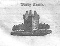
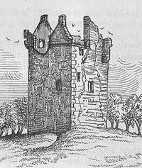 MacIntosh in 1894 refers to the castle as being "a prominent object in an otherwise monotonous landscape" and describes the gun ports and arrow slits, also a sculptured cable which wound itself fantastically round the walls. He also states that the castle probably had three floors, was roofless and fast falling into decay and regards it as being from the 14th century and probably built by the Mowat family who came from Flintshire in the 12th century.
; later several soldiers of the name de Montealt are recorded a shaving led armies into Scotland. William Craufurd of Wallston married a daughter of Mowat of Busbie circa 1400. A Charles Mowat of Busbie is mentioned in the records of 1534 as being involved in the murder of William Cunyngham of Craganis and his servant. Charles Mowat was tutor to Hugh, Earl of Eglinton in 1546. and the same Charles Mowat was fined £47 in 1571 - 2 for celebrating mass at Eglinton Castle
. In 1547 Charles Mowat was again involved in a murder, this time with Lord Boyd; Sir Neil Montgomerie of Lainshaw being the victim. His punishment was to remain in France until Sir Neil Montgomerie, son of the murdered Sir Neil, permitted him to return. It was not all one way, for a brother of the Earl of Eglinton appears in court having provoked John Mowatt, Laird of Busby, and his servant, one Andrew Stevenston in the streets of Stewarton.
The Mowat involved in the Montgomerie murder was in turn slain by William & Harrie (Sic) Stewart, the two sons of Lord Ochiltree in 1577. Alexander, the eldest son does not appear to inherit, instead James, his younger brother succeeded to the lands of Busbie. James's son, also James is the last Mowat to appear in the public record. The name de Monhaud or de Monte Alto is recorded as being pronounced 'Mowat' by Dalrymple.
James Ritchie of Craigton obtained the lands in 1763, succeeded by his son Henry in 1799, who also acquired the Cloncaird estate. William Wallace of Cairnhill (now Carnell), the nephew of Henry, next inherited the estate. General Sir James Wallace died in 1867 and passed the property to William Wallace of Busbie and Cloncaird. In 1661, Hugh, Earl of Eglinton
inherited the lands of Busbie, Knockentiber and Robertown, the family possessing these lands as far back as 1638.
 A frequently repeated legend is that of the Rev. Mr. Welsh of Ayr, who after providing several written warnings, prophesised the downfall of the house of Busbie, because the laird refused to suppress the custom of inviting guests to his house on the Sabbath day, and profaning the sabbath by playing football and other games. The prophesy was visibly fulfilled; for although the laird was very wealthy at the time, misfortune was heaped upon misfortune until he was forced to sell his estate, and when he was giving it over to the purchaser, he said with tears in his eyes, in front of his wife and children, "Now Mr. Welsh is a true prophet." This laird was the father of the Rev. Mathew (Sic) Mowat of Kilmarnock. James Mowat is the last to appear in the public records.
south to the River Irvine
. It had no manor house and belonged to the Eglinton family latterly. Hugh Montgomerie, Ist Earl of Eglinton, had a charter on 3 February 1499 from James V of the £40 lands of old extent of Roberton in Cunninghame. These lands were part of the Lands and Barony of Ardrossan; the following properties were part of the barony: parts of Kilmaurs, Knockentiber, Craig, Gatehead, Woodhills, Greenhill, Altonhill, Plann, Hayside, Thorntoun
, Rash-hill Park, Milton, Windyedge, Fardelhill, Muirfields, Corsehouse.
Knockentiber
Knockentiber is a village in East Ayrshire, Parish of Kilmaurs, Scotland. Knockentiber is WNW of Kilmarnock and 1/2 mile NE of Crosshouse. Latitude:55.6193°N Longitude:4.5455°W and . The population was 359 in 1991, however the population is much higher following the construction of several...
(Scottish Gaelic: Cnoc an Tobair, hill of the well), a village in East Ayrshire
East Ayrshire
East Ayrshire is one of 32 council areas of Scotland. It borders on to North Ayrshire, East Renfrewshire, South Lanarkshire, South Ayrshire and Dumfries and Galloway...
, Parish of Kilmaurs
Kilmaurs
Kilmaurs is a village in East Ayrshire, Scotland. It lies on the Carmel, 21.1 miles south by west of Glasgow. Population recorded in 2001 Census, 2601- History :...
, Scotland. Knockentiber is 2 miles (3.2 km) WNW of Kilmarnock
Kilmarnock
Kilmarnock is a large burgh in East Ayrshire, Scotland, with a population of 44,734. It is the second largest town in Ayrshire. The River Irvine runs through its eastern section, and the Kilmarnock Water passes through it, giving rise to the name 'Bank Street'...
and 1/2 mile NE of Crosshouse. The castle overlooked the Carmel Glen and its Burn, which runs into the River Irvine
River Irvine
The River Irvine is a river flowing through southwest Scotland, with its watershed on the Lanarkshire border of Ayrshire at an altitude of above sea-level, near Drumclog, and SW by W of Strathaven...
, a mile or so to the south, after passing through the old Busbie Mill.
The settlement
Ainslie's map of 1822 marks the site of the settlement as Bushby and Armstrong's map of 1775, illustrates Busbie Castle in a ruinous condition, but still with its old woodland policies. The 1860s first edition of the OSOrdnance Survey
Ordnance Survey , an executive agency and non-ministerial government department of the Government of the United Kingdom, is the national mapping agency for Great Britain, producing maps of Great Britain , and one of the world's largest producers of maps.The name reflects its creation together with...
shows that a pre-reformation chapel dedicated to the Virgin Mary was situated close to the site of Busbie Castle.
Busbie Castle had a small hamlet of thatched cottages clustered nearby. In 1860 the OS shows 'Old Busbie' on the opposite side of the road from the site of the castle. Busbie and Knockentiber progressively grew together over the years.
The Castle
The castle was a simple keep, about 50 feet (15.2 m) high and roughly 40 feet (12.2 m) long by 25 feet (7.6 m) wide. The entrance was on the ground floor, giving access to the wheel-stair to the first floor hall in the north-west angle and to two cellars or stores on the ground floor. The hall on the first floor had a large fireplace and two window seats.In 1465 the Registrum Magni Sigilli records - "Terras de le Moite," &c. 1539, "9 marcat. de Busby, viz., lie Mote, Knokintibber, et Hallethornis," &c. 1541, " Terras de Moite, Knokintebir," &c. 1571, "Terras de Moit," &c. 1583, "20 solidatas terrarum antiqui extentus de Moit-Mowat cum earum mansione," &c. 1599," 9 marcat. terrarum de Busbeyis (viz., lie Mote, Knockiutibber et Halythornis".
In 1691 the Laird of Busbie's dwelling had six hearths and seven other dwellings were associated with the castle and its lands.
The castle was a ruin since at least the 1770s. and was demolished in 1949 or 1952 as it had been unsafe for many years and the funds were not found to consolidate the structure. H. Ritchie had Busbie House erected as a replacement for the old castle. Busbie Estates and Collective Securities Limited owned a fair amount of land in the 1950s.
The lairds of Busbie
A Robert de Montealt (Monteacute) is recorded as being in Scotland at the time of King David IDavid I of Scotland
David I or Dabíd mac Maíl Choluim was a 12th-century ruler who was Prince of the Cumbrians and later King of the Scots...
; later several soldiers of the name de Montealt are recorded a shaving led armies into Scotland. William Craufurd of Wallston married a daughter of Mowat of Busbie circa 1400. A Charles Mowat of Busbie is mentioned in the records of 1534 as being involved in the murder of William Cunyngham of Craganis and his servant. Charles Mowat was tutor to Hugh, Earl of Eglinton in 1546. and the same Charles Mowat was fined £47 in 1571 - 2 for celebrating mass at Eglinton Castle
Eglinton Castle
Eglinton Castle was a large Gothic castellated mansion in Kilwinning, North Ayrshire, Scotland.-The castle :The ancient seat of the Earls of Eglinton, it is located just south of the town of Kilwinning...
. In 1547 Charles Mowat was again involved in a murder, this time with Lord Boyd; Sir Neil Montgomerie of Lainshaw being the victim. His punishment was to remain in France until Sir Neil Montgomerie, son of the murdered Sir Neil, permitted him to return. It was not all one way, for a brother of the Earl of Eglinton appears in court having provoked John Mowatt, Laird of Busby, and his servant, one Andrew Stevenston in the streets of Stewarton.
The Mowat involved in the Montgomerie murder was in turn slain by William & Harrie (Sic) Stewart, the two sons of Lord Ochiltree in 1577. Alexander, the eldest son does not appear to inherit, instead James, his younger brother succeeded to the lands of Busbie. James's son, also James is the last Mowat to appear in the public record. The name de Monhaud or de Monte Alto is recorded as being pronounced 'Mowat' by Dalrymple.
James Ritchie of Craigton obtained the lands in 1763, succeeded by his son Henry in 1799, who also acquired the Cloncaird estate. William Wallace of Cairnhill (now Carnell), the nephew of Henry, next inherited the estate. General Sir James Wallace died in 1867 and passed the property to William Wallace of Busbie and Cloncaird. In 1661, Hugh, Earl of Eglinton
Earl of Eglinton
Earl of Eglinton is a title in the Peerage of Scotland.Some authorities spell the title: Earl of Eglintoun In 1859 the thirteenth Earl of Eglinton, Archibald Montgomerie, was also created Earl of Winton in the Peerage of the United Kingdom, which gave him an automatic seat in the House of Lords,...
inherited the lands of Busbie, Knockentiber and Robertown, the family possessing these lands as far back as 1638.
The breaking of the sabbath
The Barony of Robertoun
This barony, once part of the Barony of Kilmaurs, ran from KilmaursKilmaurs
Kilmaurs is a village in East Ayrshire, Scotland. It lies on the Carmel, 21.1 miles south by west of Glasgow. Population recorded in 2001 Census, 2601- History :...
south to the River Irvine
River Irvine
The River Irvine is a river flowing through southwest Scotland, with its watershed on the Lanarkshire border of Ayrshire at an altitude of above sea-level, near Drumclog, and SW by W of Strathaven...
. It had no manor house and belonged to the Eglinton family latterly. Hugh Montgomerie, Ist Earl of Eglinton, had a charter on 3 February 1499 from James V of the £40 lands of old extent of Roberton in Cunninghame. These lands were part of the Lands and Barony of Ardrossan; the following properties were part of the barony: parts of Kilmaurs, Knockentiber, Craig, Gatehead, Woodhills, Greenhill, Altonhill, Plann, Hayside, Thorntoun
Thorntoun house and estate
Thorntoun School was opened by Barnardo's in September 1971 for children with emotional difficulties aged 11 to 16 years. The school closed in 1990 and Thorntoun is now a Nursing Home. The complex lies between the villages of Springside and Crosshouse, Kilmarnock in East Ayrshire, Scotland...
, Rash-hill Park, Milton, Windyedge, Fardelhill, Muirfields, Corsehouse.