
Burlington, New York
Encyclopedia
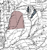
Burlington is a town
in Otsego County
, New York
, USA
. The population was 1,085 at the 2000 census.
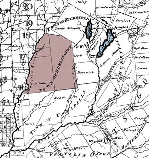
The Town of Burlington is in the northwest part of the county and is north of Oneonta
.
, the town has a total area of 45 square miles (116.5 km²), of which, 45 square miles (116.5 km²) of it is land and 0.1 square mile (0.258998811 km²) of it (0.13%) is water. 1878 history of the county states the acreage as 27,217, with an assessed valuation of $421,450 and equalized valuation of $473,576.
North-south highway New York State Route 51
and east-west highway New York State Route 80
intersect at Barrett Corners. North-south highway county route 16 and east-west highway New York State Route 80
intersects at Burlington Green.
Butternut Creek and Wharton Creek are important waterways in the town.
 Early settlers came from New England
. Township named after Burlington, New Jersey by William Cooper and Andrew Craig, early land patent owners. At an early time the Butternut Creek was dubbed "Burlington Creek" as well but the name didn't stick.
Burlington was formed from the Town of Otsego
, April 10, 1792. It retained its original dimensions until 1797, when Pittsfield
(and what would come to be New Lisbon
) was set off. It was further diminished in area by the erection of Edmeston
, in 1808.
The 1878 history describes the community of Burlington Green as having two churches, a general store, lawyer office, hotel, gristmill, creamery, two blacksmith shops, two wagon shops, a cooper and shoe shop and photography studio, but "This village at one time was a place of much more mercantile and manufacturing interest than at present, having a comb-factory, a hattery, two tanneries, an iron-foundry, a furniture-factory, three stores, two hotels, a cloth-dressing and wool carding-factory, and a card factory." The heavily textile based economy of the Butternut Valley was an influence in the number of sheep and immigrants that arrived from Scotland and established the United Presbyterian Church at Burlington Green June 8, 1835.
of 2000, there were 1,085 people, 392 households, and 301 families residing in the town. The population density
was 24.1 people per square mile (9.3/km²). There were 500 housing units at an average density of 11.1 per square mile (4.3/km²). The racial makeup of the town was 97.14% White, 0.18% African American, 0.18% Native American, 0.28% Asian, 0.37% from other races
, and 1.84% from two or more races. Hispanic or Latino of any race were 1.66% of the population.
There were 392 households out of which 36.2% had children under the age of 18 living with them, 65.1% were married couples
living together, 7.9% had a female householder with no husband present, and 23.2% were non-families. 18.6% of all households were made up of individuals and 8.2% had someone living alone who was 65 years of age or older. The average household size was 2.76 and the average family size was 3.08.
In the town the population was spread out with 26.5% under the age of 18, 7.7% from 18 to 24, 29.3% from 25 to 44, 22.6% from 45 to 64, and 13.9% who were 65 years of age or older. The median age was 38 years. For every 100 females there were 103.6 males. For every 100 females age 18 and over, there were 94.6 males.
The median income for a household in the town was $36,823, and the median income for a family was $42,500. Males had a median income of $28,000 versus $20,667 for females. The per capita income
for the town was $15,184. About 7.4% of families and 11.8% of the population were below the poverty line, including 11.5% of those under age 18 and 17.1% of those age 65 or over.
Town
A town is a human settlement larger than a village but smaller than a city. The size a settlement must be in order to be called a "town" varies considerably in different parts of the world, so that, for example, many American "small towns" seem to British people to be no more than villages, while...
in Otsego County
Otsego County, New York
Otsego County is a county located in the U.S. state of New York. The 2010 population was 62,259. The county seat is Cooperstown. The name Otsego is from a Mohawk word meaning "place of the rock."-History:...
, New York
New York
New York is a state in the Northeastern region of the United States. It is the nation's third most populous state. New York is bordered by New Jersey and Pennsylvania to the south, and by Connecticut, Massachusetts and Vermont to the east...
, USA
United States
The United States of America is a federal constitutional republic comprising fifty states and a federal district...
. The population was 1,085 at the 2000 census.
The Town of Burlington is in the northwest part of the county and is north of Oneonta
Oneonta, New York
Oneonta is a city in southern Otsego County, New York, USA. As of the 2010 U.S. Census, had a population of 13,901. Its nickname is "City of the Hills." While the word "oneonta" is of undetermined origin, it is popularly believed to mean "place of open rocks" in the Iroquois language...
.
Geography
According to the United States Census BureauUnited States Census Bureau
The United States Census Bureau is the government agency that is responsible for the United States Census. It also gathers other national demographic and economic data...
, the town has a total area of 45 square miles (116.5 km²), of which, 45 square miles (116.5 km²) of it is land and 0.1 square mile (0.258998811 km²) of it (0.13%) is water. 1878 history of the county states the acreage as 27,217, with an assessed valuation of $421,450 and equalized valuation of $473,576.
North-south highway New York State Route 51
New York State Route 51
New York State Route 51 is a state highway in the central part of New York state. The highway runs generally in a southwest to northeast direction from the hamlet of Mount Upton to the village of Ilion...
and east-west highway New York State Route 80
New York State Route 80
New York State Route 80 is a west–east New York State Route located within Onondaga, Madison, Chenango, Otsego, Herkimer, and Montgomery Counties in New York. Its western terminus is located at a junction with NY 175 in the city of Syracuse in Onondaga County, from which it...
intersect at Barrett Corners. North-south highway county route 16 and east-west highway New York State Route 80
New York State Route 80
New York State Route 80 is a west–east New York State Route located within Onondaga, Madison, Chenango, Otsego, Herkimer, and Montgomery Counties in New York. Its western terminus is located at a junction with NY 175 in the city of Syracuse in Onondaga County, from which it...
intersects at Burlington Green.
Butternut Creek and Wharton Creek are important waterways in the town.
History
New England
New England is a region in the northeastern corner of the United States consisting of the six states of Maine, New Hampshire, Vermont, Massachusetts, Rhode Island, and Connecticut...
. Township named after Burlington, New Jersey by William Cooper and Andrew Craig, early land patent owners. At an early time the Butternut Creek was dubbed "Burlington Creek" as well but the name didn't stick.
Burlington was formed from the Town of Otsego
Otsego, New York
Otsego is a town in Otsego County, New York, United States. The population was 3,904 at the 2000 census. The town is named after a lake on its border.The Town of Otsego is in the north central part of the county.- History :...
, April 10, 1792. It retained its original dimensions until 1797, when Pittsfield
Pittsfield, New York
Pittsfield is a town in Otsego County, New York, United States. The population was 1,295 at the 2000 census.The Town of Pittsfield is on the west border of the county, northwest of the City of Oneonta.- History :...
(and what would come to be New Lisbon
New Lisbon, New York
New Lisbon is a town in Otsego County, New York, United States. The population was 1,116 at the 2000 census.The Town of New Lisbon is in the west-central part of the county. It is north of the City of Oneonta.- History :...
) was set off. It was further diminished in area by the erection of Edmeston
Edmeston, New York
Edmeston is a town located in Otsego County, New York, United States. As of the 2000 census, the town had a total population of 1,824.The Town of Edmeston is at the western county line. Edmeston is also the name of the largest hamlet in the town...
, in 1808.
The 1878 history describes the community of Burlington Green as having two churches, a general store, lawyer office, hotel, gristmill, creamery, two blacksmith shops, two wagon shops, a cooper and shoe shop and photography studio, but "This village at one time was a place of much more mercantile and manufacturing interest than at present, having a comb-factory, a hattery, two tanneries, an iron-foundry, a furniture-factory, three stores, two hotels, a cloth-dressing and wool carding-factory, and a card factory." The heavily textile based economy of the Butternut Valley was an influence in the number of sheep and immigrants that arrived from Scotland and established the United Presbyterian Church at Burlington Green June 8, 1835.
Notable residents
- Benjmain Franklin Angel, (1815–1894), born in Burlington, former ambassador of the United States
- Artemas Holdredge 1823 - , cheese manufacturer, patented the idea of packaging cheese in rectangular boxes for easier shipping and shelf stacking in stores, as opposed to traditional wheel or round cheese and boxes.
- Jedediah PeckJedediah PeckJedediah Peck was an American farmer, surveyor, Revolutionary War soldier, and New York State legislator described as a father of the common school system of the State of New York. He was a man of limited education and had no gift as a debater or speaker, but he was a skillful organizer...
, a.k.a. "Ploughjogger", one of several Lyme. CT natives to pioneer in this town, Revolutionary War soldier, millwright, surveyor, essayist, first town supervisor and member NY State assembly, he promoted the establishment of public schools, and the abolishment of debtor's prison in NY state. Arguing in favor of rule by commoners rather than elistists he wrote: "The people can never mean to do anything that will not advance the public good, and it is only under momentary delusion that they can act wrong." Antagonist of Federalist everywhere he gathered petition signatures against the Alien and Sedition Acts, which led to his arrest by Judge Cooper and transport in open wagon in the fall of 1799, to New York City for trial. It is claimed sympathy at the sight of him convinced the weight of the New York electoral votes to be cast in favor of Thomas Jefferson. Today there are several state historical markers for Peck, one at his grave on route 80 east of Burlington Green, and two on route 20 in Richfield, commemorating his work as a millwright.
- Levi Miller, Revolutionary War veteran, relocated to Burlington, NY after being forced to sell his family cow to pay church tax in Massachusetts, (there is a question of family involvement in Shay's Rebellion?), established a gun factory on the Butternut north of Burlington Green.
- Arthur J. "Putt" Telfer, early photographer, studio in Cooperstown but family homestead was at intersection of Schwerd Roads near Patent in a house since removed for the Marcy South powerline.
Demographics
As of the censusCensus
A census is the procedure of systematically acquiring and recording information about the members of a given population. It is a regularly occurring and official count of a particular population. The term is used mostly in connection with national population and housing censuses; other common...
of 2000, there were 1,085 people, 392 households, and 301 families residing in the town. The population density
Population density
Population density is a measurement of population per unit area or unit volume. It is frequently applied to living organisms, and particularly to humans...
was 24.1 people per square mile (9.3/km²). There were 500 housing units at an average density of 11.1 per square mile (4.3/km²). The racial makeup of the town was 97.14% White, 0.18% African American, 0.18% Native American, 0.28% Asian, 0.37% from other races
Race (United States Census)
Race and ethnicity in the United States Census, as defined by the Federal Office of Management and Budget and the United States Census Bureau, are self-identification data items in which residents choose the race or races with which they most closely identify, and indicate whether or not they are...
, and 1.84% from two or more races. Hispanic or Latino of any race were 1.66% of the population.
There were 392 households out of which 36.2% had children under the age of 18 living with them, 65.1% were married couples
Marriage
Marriage is a social union or legal contract between people that creates kinship. It is an institution in which interpersonal relationships, usually intimate and sexual, are acknowledged in a variety of ways, depending on the culture or subculture in which it is found...
living together, 7.9% had a female householder with no husband present, and 23.2% were non-families. 18.6% of all households were made up of individuals and 8.2% had someone living alone who was 65 years of age or older. The average household size was 2.76 and the average family size was 3.08.
In the town the population was spread out with 26.5% under the age of 18, 7.7% from 18 to 24, 29.3% from 25 to 44, 22.6% from 45 to 64, and 13.9% who were 65 years of age or older. The median age was 38 years. For every 100 females there were 103.6 males. For every 100 females age 18 and over, there were 94.6 males.
The median income for a household in the town was $36,823, and the median income for a family was $42,500. Males had a median income of $28,000 versus $20,667 for females. The per capita income
Per capita income
Per capita income or income per person is a measure of mean income within an economic aggregate, such as a country or city. It is calculated by taking a measure of all sources of income in the aggregate and dividing it by the total population...
for the town was $15,184. About 7.4% of families and 11.8% of the population were below the poverty line, including 11.5% of those under age 18 and 17.1% of those age 65 or over.
Communities and locations in the Town of Burlington
- Barrett Corners – A hamlet south of Burlington Flats on NY-51 at its intersection with NY-80.
- Basswood Pond State Park – Artificial lake on headwaters of the Butternut Creek built by NYS about 1961 as a day use area west of county route 16 in the north part of town.
- Beverly Inn Corners – A hamlet north of Burlington Flats on NY-51.
- Burlington Flats – A hamlet in the western part of the town located on route NY-51. Originally called "Walbridge Flats".
- Burlington – The hamlet of Burlington is located on NY-80. Unofficially it is still called by its original name "Burlington Green" or simply "The Green".
- Chapinville – A hamlet south of Burlington Flats on NY-51.
- Cranberry Bog – Bog or vly in the southeast section of town on the headwaters of the Otego Creek.
- Clock Hill – Once claimed as the highest point in Otsego County, a century ago they even had a wooden observation tower built for tourists and were locked in bitter debate with folks in Maryland that claimed Hooker Mtn. was tallest. (Lutheranville Hill in East Worcester actually the highest). Actually named for a resident whose name was "Klock".
- Methodist Hollow – A location near the south town line.
- Patent – A hamlet near the southeast corner of town.
- Pecktown – A hamlet near the north town line.
- Round Top – A hill north of NY-80.
- West BurlingtonWest Burlington, New YorkWest Burlington is a hamlet in the western part of the Town of Burlington in Otsego County, New York. It is located at , three miles east of the town of Edmeston on New York State Route 51 and New York State Route 80....
– A hamlet near the west town line on conjoined routes NY-51 and NY-80. - Wharton – An historic location in the northwest part of the town.
- Wharton Creek – A stream flowing through the west part of the town.