
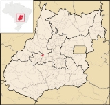
Buriti de Goiás
Encyclopedia
| Buriti de Goiás | |
|---|---|
| State | Goiás Goiás Goiás is a state of Brazil, located in the central part of the country. The name Goiás comes from the name of an indigenous community... |
| Area: | 200.0 km² |
| Population: | 2,238 (IBGE 2007) |
| Elevation: | 520m above sea level |
| Postcode (CEP): | 76152-000 |
| IBGE statistical microregion: | Anicuns Microregion Anicuns Microregion The Anicuns Microregion is a geographical division in the state of Goiás, Brazil. It is made up of 13 municipalities located near Anicuns, a small city and municipality west of Goiânia... |
| Became a city: | 1993 |
| Distance to Goiânia Goiânia -Climate:The city has a tropical wet and dry climate with an average temperature of . There's a wet season, from October to April, and a dry one, from May to September. Annual rainfall is around 1,520 mm.... : |
174 km. |
| Website: | none |
| Geographical coordinates: | 16°09′S 50°26′W |
Town
A town is a human settlement larger than a village but smaller than a city. The size a settlement must be in order to be called a "town" varies considerably in different parts of the world, so that, for example, many American "small towns" seem to British people to be no more than villages, while...
and municipality
Municipality
A municipality is essentially an urban administrative division having corporate status and usually powers of self-government. It can also be used to mean the governing body of a municipality. A municipality is a general-purpose administrative subdivision, as opposed to a special-purpose district...
in eastern Goiás
Goiás
Goiás is a state of Brazil, located in the central part of the country. The name Goiás comes from the name of an indigenous community...
state, Brazil
Brazil
Brazil , officially the Federative Republic of Brazil , is the largest country in South America. It is the world's fifth largest country, both by geographical area and by population with over 192 million people...
.
Location and Communications
- Distance to regional center (São Luís de Montes BelosSão Luís de Montes BelosSão Luís de Montes Belos is a small city and municipality in the State of Goiás, Brazil.-Location:It is located in the Anicuns Microregion, 123 kilometers from the state capital, Goiânia, to which it is connected by highway GO-060...
): 58 km.
Highway connections are made by state highway BR-069 west from Goiânia
Goiânia
-Climate:The city has a tropical wet and dry climate with an average temperature of . There's a wet season, from October to April, and a dry one, from May to September. Annual rainfall is around 1,520 mm....
, through Trindade
Trindade
-Transportation:Trindade are linked with São Tomé and Príncipe's only highways linking to the capital city of São Tomé, another linking Neves and Santana and another linking to Guadalupe as well....
, Santa Bárbara de Goiás
Santa Bárbara de Goiás
Santa Bárbara de Goiás is a small town and municipality in eastern Goiás state, Brazil.-Location:Santa Bárbara is located due west of Goiânia. Nearby towns are Trindade , and Nazário is 25 km...
, São Luís de Montes Belos
São Luís de Montes Belos
São Luís de Montes Belos is a small city and municipality in the State of Goiás, Brazil.-Location:It is located in the Anicuns Microregion, 123 kilometers from the state capital, Goiânia, to which it is connected by highway GO-060...
, and then 58 kilometers northeast to Buriti de Goiás. Neighboring municipalities are Córrego do Ouro
Córrego do Ouro
Córrego do Ouro is a small town and municipality in eastern Goiás state, Brazil.-Location and Highway Connections:Córrego do Ouro is located in the Iporá Microregion west of the state capital, Goiânia. It is 45 km. northwest of São Luís de Montes Belos, the largest town in the region. ...
, Fazenda Nova
Fazenda Nova
Fazenda Nova is a small town and municipality in central-west Goiás state, Brazil.-Location:Fazenda Nova is located northwest of the state capital, Goiânia, which is 206 km. away taking highways GO-418 and GO-060...
, Novo Brasil
Novo Brasil
Novo Brasil is a small town and municipality in eastern Goiás state, Brazil.-Location:Novo Brasil is located east of the capital near Iporá and São Luís de Montes Belos.*Distance to the state capital: 200 km....
, Goiás
Goiás, Goiás
Goiás is a small city and municipality in the state of Goiás in Brazil. The population was 24,072 in a total area of 3,108 km² . It is the former capital of the state and preserves much of its colonial heritage...
, Mossâmedes
Mossâmedes
Mossâmedes is a small town and municipality in western Goiás state, Brazil.-Location:Mossâmedes is located northwest of the state capital, Goiânia in the Anicuns Microregion. It is connected by paved roads with Itaberaí to the north and Anicuns to the south. The distance to the state capital is...
, and Sanclerlândia
Sanclerlândia
Sanclerlândia is a small town and municipality in western Goiás state, Brazil. The population was 7,641 in 2005 and the total area of the municipality was 496.8 km².-Location:...
Demographic and Political Data
- Population density in 2007: 11.23 inhab/km²
- Population growth rate 2000-2007: -2.43.%
- Urban population in 2007: 1,487
- Rural population in 2007: 751
- Eligible voters in 2007: 2638
- City government in 2007: mayor (Altamiro Antônio da Silva), vice-mayor (José Sérgio Magno), and 09 councilpersons
- Income distribution: In 823 households, 407 earned less than one minimum salary in 2000.
Economy
The economy is based on cattle raising, agriculture and small transformation industries. In 2006 there were 24,000 head of cattle, including 3,570 head of milking cows. There was modest production of rice, bananas, coconut, papaya, manioc, corn, and hearts of palm.Health and education
- Infant mortality in 2000: 24.88
- Hospitals: 01 with 14 beds (2007)
- Literacy rate: 86.8 in 2000
- Schools: 03 in 2006
- Students: 765
- Higher education: none in 2006
- MHDI: 0.731
- State ranking: 142 (out of 242 municipalities)
- National ranking: 2396 (out of 5507 municipalities)