
Burgeo and La Poile
Encyclopedia
Burgeo-La Poile is a provincial
electoral district
for the House of Assembly
of Newfoundland and Labrador
, Canada
. As of 2011, there are 7,527 eligible voters living within the district.
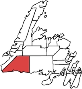
Takes in the southwestern corner of Newfoundland, stretching from the town of Burgeo
in the east to Cape Ray in the west. Its largest community, Port aux Basques, is the island's link to continental North America through the Marine Atlantic
ferry service. The district, especially the town of Burgeo
, has been hit hard by the closure of groundfisheries.
The population in the region dropped by about 15 per cent between 1996 and 2001. The size of the district grew significantly in the 2007 redistribution as the eastern border pushed out an extra 37 kilometres.
The district is one of the strongest Liberal regions of the province, and was one of only three districts to return a Liberal MHA in the 2007 election
.
Beginning at the point of intersection with the Meridian
of 57 degrees West
Longitude and the shoreline of the southwest coast, located east of the community of Grey River
; Thence running due north along the Meridian of 57 degrees West
Longitude to its intersection with the Parallel of 48 degrees 30 minutes North Latitude; Thence running west along the Parallel of 48 degrees 30 minutes North Latitude to its intersection with the Meridian of 58 degrees West
Longitude; Thence running in a southwesterly direction to the point of land known as Red Rocks
, located on the eastern shoreline of Cabot Strait
, north of Cape Ray
; Thence running in a general easterly direction along the sinuosities of the southwest coast to the point of beginning, together with Burgeo Island, Ramea Island and all other islands adjacent thereto.
All geographic coordinates being scaled and referenced to the Universal Transverse Mercator Map Projection
and the North American Datum
of 1983.
. The federal district includes the south coast of the island of Newfoundland, the Stephenville area, the Burin Peninsula
, and the west-central coast of Trinity Bay
including Random Island
, Brunette Island
, Long Island
, Merasheen Island
, Red Island and the Ramea Islands.
|Liberal
|Andrew Parsons
|align="right"|2228
|align="right"|52.12%
|align="right"|
|-
|Progressive Conservative
|Colin Short
|align="right"|1850
|align="right"|43.27%
|align="right"|
|-
|NDP
|Matt Fuchs
|align="right"|197
|align="right"|4.61%
|align="right"|
|}
|-
|Liberal
|Kelvin Parsons
|align="right"|2882
|align="right"|59.66%
|align="right"|
|-
|Progressive Conservative
|Colin M. Short
|align="right"|1864
|align="right"|38.58%
|align="right"|
|-
|NDP
|June Hiscock
|align="right"|85
|align="right"|1.76%
|align="right"|
|}
|-
|Liberal
|Kelvin Parsons
|align="right"|4233
|align="right"|80.76%
|align="right"|+21.28%
|-
|Progressive Conservative
|Stephen P. Mackenzie
|align="right"|1008
|align="right"|19.23%
|align="right"|-15.34%
|}
|-
|Liberal
|Kelvin Parsons
|align="right"|3421
|align="right"|59.48%
|align="right"|
|-
|Progressive Conservative
|Greg Sheaves
|align="right"|1988
|align="right"|34.57%
|align="right"|
|-
|NDP
|O. Marsden
|align="right"| 342
|align="right"|5.95%
|align="right"|
|}
|Liberal
|Bill Ramsay
|align="right"|3598
|align="right"|
|align="right"|
|Progressive Conservative
|Cheryl Stagg
|align="right"|2382
|align="right"|
|align="right"|
|-
|}
Provinces and territories of Canada
The provinces and territories of Canada combine to make up the world's second-largest country by area. There are ten provinces and three territories...
electoral district
Electoral district
An electoral district is a distinct territorial subdivision for holding a separate election for one or more seats in a legislative body...
for the House of Assembly
Newfoundland and Labrador House of Assembly
The Newfoundland and Labrador House of Assembly is one of two components of the General Assembly of Newfoundland and Labrador, the other being the Lieutenant-Governor of Newfoundland and Labrador. The Newfoundland and Labrador General Assembly meets in the Confederation Building at St...
of Newfoundland and Labrador
Newfoundland and Labrador
Newfoundland and Labrador is the easternmost province of Canada. Situated in the country's Atlantic region, it incorporates the island of Newfoundland and mainland Labrador with a combined area of . As of April 2011, the province's estimated population is 508,400...
, Canada
Canada
Canada is a North American country consisting of ten provinces and three territories. Located in the northern part of the continent, it extends from the Atlantic Ocean in the east to the Pacific Ocean in the west, and northward into the Arctic Ocean...
. As of 2011, there are 7,527 eligible voters living within the district.
Takes in the southwestern corner of Newfoundland, stretching from the town of Burgeo
Burgeo
Burgeo is a Canadian town located on the south coast of the island of Newfoundland in the province of Newfoundland and Labrador.The town is approximately 75 miles east of Channel-Port aux Basques....
in the east to Cape Ray in the west. Its largest community, Port aux Basques, is the island's link to continental North America through the Marine Atlantic
Marine Atlantic
Marine Atlantic Inc. is an independent Canadian Crown corporation offering ferry services between the provinces of Newfoundland and Labrador and Nova Scotia.Marine Atlantic's corporate headquarters are in St...
ferry service. The district, especially the town of Burgeo
Burgeo
Burgeo is a Canadian town located on the south coast of the island of Newfoundland in the province of Newfoundland and Labrador.The town is approximately 75 miles east of Channel-Port aux Basques....
, has been hit hard by the closure of groundfisheries.
The population in the region dropped by about 15 per cent between 1996 and 2001. The size of the district grew significantly in the 2007 redistribution as the eastern border pushed out an extra 37 kilometres.
The district is one of the strongest Liberal regions of the province, and was one of only three districts to return a Liberal MHA in the 2007 election
Newfoundland and Labrador general election, 2007
The 47th Newfoundland and Labrador general election was held on October 9, 2007 to elect members of the 46th General Assembly of Newfoundland and Labrador, the 18th general election for the province of Newfoundland and Labrador, Canada.-Campaign:...
.
Geography
The district includes the part of the province of Newfoundland and Labrador bounded as follows:Beginning at the point of intersection with the Meridian
Meridian (geography)
A meridian is an imaginary line on the Earth's surface from the North Pole to the South Pole that connects all locations along it with a given longitude. The position of a point along the meridian is given by its latitude. Each meridian is perpendicular to all circles of latitude...
of 57 degrees West
57th meridian west
The meridian 57° west of Greenwich is a line of longitude that extends from the North Pole across the Arctic Ocean, North America, the Atlantic Ocean, South America, the Southern Ocean, and Antarctica to the South Pole....
Longitude and the shoreline of the southwest coast, located east of the community of Grey River
Grey River, Newfoundland and Labrador
Grey River is a small remote fishing community located on the south coast of the province of Newfoundland and Labrador, Canada.-See also:* List of cities and towns in Newfoundland and Labrador...
; Thence running due north along the Meridian of 57 degrees West
57th meridian west
The meridian 57° west of Greenwich is a line of longitude that extends from the North Pole across the Arctic Ocean, North America, the Atlantic Ocean, South America, the Southern Ocean, and Antarctica to the South Pole....
Longitude to its intersection with the Parallel of 48 degrees 30 minutes North Latitude; Thence running west along the Parallel of 48 degrees 30 minutes North Latitude to its intersection with the Meridian of 58 degrees West
58th meridian west
The meridian 58° west of Greenwich is a line of longitude that extends from the North Pole across the Arctic Ocean, North America, the Atlantic Ocean, South America, the Southern Ocean, and Antarctica to the South Pole....
Longitude; Thence running in a southwesterly direction to the point of land known as Red Rocks
Red Rocks, Newfoundland and Labrador
Red Rocks was a CNR station located northeast of Port aux Basques. It was closed and depopulated in September 1966.-See also:*List of communities in Newfoundland and Labrador...
, located on the eastern shoreline of Cabot Strait
Cabot Strait
Cabot Strait is a strait in eastern Canada approximately 110 kilometres wide between Cape Ray, Newfoundland and Cape North, Cape Breton Island. It is the widest of the three outlets for the Gulf of Saint Lawrence into the Atlantic Ocean, the others being the Strait of Belle Isle and Strait of Canso...
, north of Cape Ray
Cape Ray
Cape Ray is a headland located at the southwestern extremity of the island of Newfoundland in the Canadian province of Newfoundland and Labrador....
; Thence running in a general easterly direction along the sinuosities of the southwest coast to the point of beginning, together with Burgeo Island, Ramea Island and all other islands adjacent thereto.
All geographic coordinates being scaled and referenced to the Universal Transverse Mercator Map Projection
Universal Transverse Mercator coordinate system
The Universal Transverse Mercator geographic coordinate system uses a 2-dimensional Cartesian coordinate system to give locations on the surface of the Earth. It is a horizontal position representation, i.e...
and the North American Datum
North American Datum
The North American Datum is the official datum used for the primary geodetic network in North America.In the fields of cartography and land-use there are currently two North American Datums in use: the North American Datum of 1927 and the North American Datum of 1983...
of 1983.
Federal riding
The provincial boundary of this district falls entirely within the federal district of Random—Burin—St. George'sRandom—Burin—St. George's
Random—Burin—St. George's is a federal electoral district in Newfoundland and Labrador, Canada, that has been represented in the Canadian House of Commons since 2004.-Demographics:Ethnic groups: 94.7% White, 4.8% Native Canadian...
. The federal district includes the south coast of the island of Newfoundland, the Stephenville area, the Burin Peninsula
Burin Peninsula
The Burin Peninsula is a Canadian peninsula located on the south coast of the island of Newfoundland in the province of Newfoundland and Labrador....
, and the west-central coast of Trinity Bay
Trinity Bay, Newfoundland and Labrador
Trinity Bay is a large bay on the northeastern coast of Newfoundland in the Canadian province of Newfoundland and Labrador.Major fishing communities include Trinity and Heart's Content.-Industry:...
including Random Island
Random Island
Random Island is located off Canada's Atlantic coast. Part of the Canadian province of Newfoundland and Labrador, it is located on the east coast of Newfoundland and semi-surrounded by the Bonavista Peninsula on the north and within the confines of Trinity Bay...
, Brunette Island
Brunette Island
Brunette Island is an island in Newfoundland and Labrador, Canada, the largest island in the Fortune Bay.In 1964, buffalo were introduced to the island as an economic development experiment....
, Long Island
Long Island (disambiguation)
Long Island is an island and geographical area of New York State. It may also refer to:- Australia :* Long Island , an island in the Hawkesbury River north of Sydney, New South Wales...
, Merasheen Island
Merasheen Island
Merasheen Island is an island in Newfoundland and Labrador, Canada. With a length of approximately 35 km and a width at its widest point of 9 km, it is situated about 6 km from Presque. It is the largest island in the Placentia Bay....
, Red Island and the Ramea Islands.
Communities
|
|
|
|
Burgeo-Lapoile/Lapoile
| Member | Party | Term | |
|---|---|---|---|
| Andrew Parsons Andrew Parsons (Canadian politician) Andrew Parsons is a Canadian politician in Newfoundland and Labrador. He was elected to the Newfoundland and Labrador House of Assembly in the 2011 provincial election. A member of the Liberal Party of Newfoundland and Labrador, he represents the electoral district of Burgeo-La Poile.He is the son... |
Liberal Liberal Party of Newfoundland and Labrador The Liberal Party of Newfoundland and Labrador is a political party in the province of Newfoundland and Labrador, Canada and the provincial wing of the Liberal Party of Canada. It is the Official Opposition and currently holds six seats in the provincial legislature.-Origins:The party originated in... |
2011-present |
Kelvin Parsons Kelvin Parsons Kelvin Parsons is a Canadian politician in Newfoundland and Labrador, Canada. He represented the district of Burgeo and La Poile from 1999 to 2011... |
Liberal | 1999–2011 |
Bill Ramsay | Liberal | 1989–1999 |
Calvin Mitchell | Progressive Conservative Progressive Conservative Party of Newfoundland and Labrador For pre-1949 Conservative parties see Conservative parties in Newfoundland The Progressive Conservative Party of Newfoundland and Labrador is a centre-right provincial political party in Newfoundland and Labrador, Canada. Originally founded in 1949 the party has formed the Government of... |
1985–1989 |
Steve Neary Steve Neary Stephen Aloysius Neary is a former politician and cabinet minister in Newfoundland and Labrador.Neary worked at the Argentia Naval Base until 1945 before moving to a job at the Dominion Steel Company on Bell Island... |
Liberal | 1975-1985 |
Allen Evans | Progressive Conservative Progressive Conservative Party of Newfoundland and Labrador For pre-1949 Conservative parties see Conservative parties in Newfoundland The Progressive Conservative Party of Newfoundland and Labrador is a centre-right provincial political party in Newfoundland and Labrador, Canada. Originally founded in 1949 the party has formed the Government of... |
1971–1975 |
Walter Hodder | Liberal | 1962-1971 |
| John Cheeseman | Liberal | 1956-1962 | |
| George Norman | Liberal | 1951-1956 | |
| Herman Quinton | Liberal | 1949-1951 | |
Burgeo-Bay d'Espoir
| Member | Party | Term | |
|---|---|---|---|
| David Gilbert | Liberal | 1985-1996 | |
| Harold Andrews | Progressive Conservative Progressive Conservative Party of Newfoundland and Labrador For pre-1949 Conservative parties see Conservative parties in Newfoundland The Progressive Conservative Party of Newfoundland and Labrador is a centre-right provincial political party in Newfoundland and Labrador, Canada. Originally founded in 1949 the party has formed the Government of... |
1979-1985 | |
| Roger Simmons | Liberal | 1975-1979 | |
Election results
|-|Liberal
|Andrew Parsons
|align="right"|2228
|align="right"|52.12%
|align="right"|
|-
|Progressive Conservative
|Colin Short
|align="right"|1850
|align="right"|43.27%
|align="right"|
|-
|NDP
|Matt Fuchs
|align="right"|197
|align="right"|4.61%
|align="right"|
|}
|-
|Liberal
|Kelvin Parsons
|align="right"|2882
|align="right"|59.66%
|align="right"|
|-
|Progressive Conservative
|Colin M. Short
|align="right"|1864
|align="right"|38.58%
|align="right"|
|-
|NDP
|June Hiscock
|align="right"|85
|align="right"|1.76%
|align="right"|
|}
|-
|Liberal
|Kelvin Parsons
|align="right"|4233
|align="right"|80.76%
|align="right"|+21.28%
|-
|Progressive Conservative
|Stephen P. Mackenzie
|align="right"|1008
|align="right"|19.23%
|align="right"|-15.34%
|}
|-
|Liberal
|Kelvin Parsons
|align="right"|3421
|align="right"|59.48%
|align="right"|
|-
|Progressive Conservative
|Greg Sheaves
|align="right"|1988
|align="right"|34.57%
|align="right"|
|-
|NDP
|O. Marsden
|align="right"| 342
|align="right"|5.95%
|align="right"|
|}
|Liberal
|Bill Ramsay
|align="right"|3598
|align="right"|
|align="right"|
|Progressive Conservative
|Cheryl Stagg
|align="right"|2382
|align="right"|
|align="right"|
|-
|}