

Brothers Fault Zone
Encyclopedia
Brothers, Oregon
Brothers is an unincorporated community in Deschutes County, Oregon, United States on U.S. Route 20. It is part of the Bend, Oregon Metropolitan Statistical Area. It lies at an elevation of above sea level.-History:...
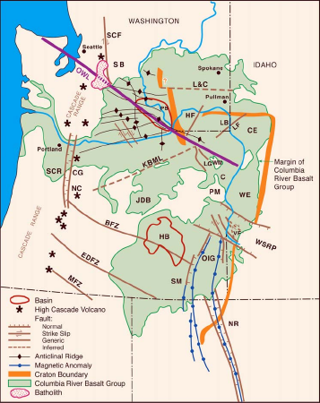
— is the most notable of a set of northwest trending fault zones including the Eugene—Denio, McLouglin, and Vale zones that dominate the geological structure of most of Oregon
Oregon
Oregon is a state in the Pacific Northwest region of the United States. It is located on the Pacific coast, with Washington to the north, California to the south, Nevada on the southeast and Idaho to the east. The Columbia and Snake rivers delineate much of Oregon's northern and eastern...
. These are also representative of a regional pattern of generally northwest striking geological features ranging from Walker Lane
Walker Lane
The Walker Lane is a geologic trough roughly aligned with the California/Nevada border southward to where Death Valley intersects the Garlock Fault, a major left-lateral strike-slip fault...
on the California—Nevada border to the Olympic-Wallowa Lineament
Olympic-Wallowa Lineament
The Olympic-Wallowa lineament – first reported by cartographer Erwin Raisz in 1945 on a relief map of the continental United States – is a physiographic feature of unknown origin in the state of Washington running approximately from the town of Port Angeles, on the Olympic Peninsula...
in Washington; these are generally associated with the regional extension and faulting of the Basin and Range Province, of which the BFZ is considered the northern boundary.
The relationships with other features is complex. At the BFZ's eastern end, near the Steens Mountain
Steens Mountain
Steens Mountain is a large fault-block mountain in the southeastern part of the U.S. state of Oregon. Located in Harney County, it stretches some and rises from an elevation of about above the Alvord Desert to its peak at...
fault, the zone of surface faulting turns slightly to the south-southeast (possibly due to rotation of Nevada), then follows the Northern Nevada Rift to form the Oregon—Nevada lineament, with a total length of over 750 km (450 miles). Lavas associated with the Nevada Rift have been dated to 16.3 Ma (millions of years ago), close to the inception of basin-and-range faulting, but there is a suspicion that the rifting developed on an older strike-slip fault, possibly connected with the East Pacific Rise
East Pacific Rise
The East Pacific Rise is a mid-oceanic ridge, a divergent tectonic plate boundary located along the floor of the Pacific Ocean. It separates the Pacific Plate to the west from the North American Plate, the Rivera Plate, the Cocos Plate, the Nazca Plate, and the Antarctic Plate...
.
At its west end, just past the Newberry Volcano
Newberry Volcano
Newberry Volcano is a large potentially active shield volcano located east of the Cascade Range and about southeast of Bend, Oregon. It is not a typical shield volcano. In addition to erupting basaltic lavas, it also has erupted andesitic and even rhyolitic lava.The volcano is in diameter and...
, the BFZ terminates at the north-striking Sisters Fault, part of the High Cascades geological province. But further south the Pliocene
Pliocene
The Pliocene Epoch is the period in the geologic timescale that extends from 5.332 million to 2.588 million years before present. It is the second and youngest epoch of the Neogene Period in the Cenozoic Era. The Pliocene follows the Miocene Epoch and is followed by the Pleistocene Epoch...
(<5 Ma) High Cascades volcanic trend is offset right-laterally about 10 to 20 km (6 to 12 miles) by the Eugene—Denio fault zone, and another 15 to 20 km by the McLouglin zone.
At a possibly more fundamental level, the Brothers, Eugene-Denio, and McLouglin zones, and possibly the Vale zone, all terminate near the Klamath—Blue Mountains Lineament (KBML; shortened and slightly misplaced on the map at right). The KBML is a prominent, 700 km long SW-NE striking gravitational anomaly that crosses all of Oregon. It coincides with the southern boundary of the Columbia Embayment (the Olympic-Wallowa Lineament in Washington being the northern boundary), a region noticeably lacking in pre-Tertiary
Tertiary
The Tertiary is a deprecated term for a geologic period 65 million to 2.6 million years ago. The Tertiary covered the time span between the superseded Secondary period and the Quaternary...
bedrock. Aside from aligning with the northernwestern edge of several terranes that have accreted to the North American continent (such as the Klamath Mountains
Klamath Mountains
The Klamath Mountains, which include the Siskiyou, Marble, Scott, Trinity, Trinity Alps, Salmon, and northern Yolla-Bolly Mountains, are a rugged lightly populated mountain range in northwest California and southwest Oregon in the United States...
on the southern coast of Oregon, and Blue Mountains Province just north of the BFZ), the KBML has no apparent surface manifestation; it is believed to reflect a deeper structure, possible a pre-Tertiary continental margin.
The BFZ is the northern edge of the Basin and Range Province, a region of northwest directed extension, wherefore the BFZ also accommodates the offset with the Blue Mountains Province. It does this not by through-going strike-slip faulting (such as with the San Andreas fault
San Andreas Fault
The San Andreas Fault is a continental strike-slip fault that runs a length of roughly through California in the United States. The fault's motion is right-lateral strike-slip...
to the southwest) but by a series of hundreds of en echelon normal faults somewhat crosswise to the zone itself. Such faulting is believed to be the surface manifestation of a deeper sheer zone.
The Brothers Fault Zone is also the locus of the High Lava Plains (HLP) volcanism of central and southeastern Oregon. HLP volcanism is notable for showing an age progression from 16 Ma from its eastern end (near the Oregon—Nevada—Idaho corner) to a mere 1 Ma young Newberry Volcano
Newberry Volcano
Newberry Volcano is a large potentially active shield volcano located east of the Cascade Range and about southeast of Bend, Oregon. It is not a typical shield volcano. In addition to erupting basaltic lavas, it also has erupted andesitic and even rhyolitic lava.The volcano is in diameter and...
at its western end. This age progression mirrors the very similar progression along the track of the Yellowstone Hotspot
Yellowstone hotspot
The Yellowstone hotspot, also referred to as the Snake River Plain-Yellowstone hotspot, is a volcanic hotspot responsible for large scale volcanism in Oregon, Nevada, Idaho, and Wyoming, United States. It created the eastern Snake River Plain through a succession of caldera forming eruptions...
, which appears to have a common origin. Also closely related in space and time is the eruption of the 16.6 Ma Steens Basalts, the initial and most voluminous phase of the Columbia River Basalt Group
Columbia River Basalt Group
The Columbia River Basalt Group is a large igneous province that lies across parts of the Western United States. It is found in the U.S. states of Washington, Oregon, Idaho, Nevada, and California...
lava flows that blanket eastern Oregon and the entire southeastern quarter of Washington. These also show a similar age progression to the north; there is a great deal of debate on how all of these are related, and how they initiated. The track of the Yellowstone Hotspot is neatly explained by motion of the North American craton
Craton
A craton is an old and stable part of the continental lithosphere. Having often survived cycles of merging and rifting of continents, cratons are generally found in the interiors of tectonic plates. They are characteristically composed of ancient crystalline basement rock, which may be covered by...
over a plume (hotspot
Hotspot (geology)
The places known as hotspots or hot spots in geology are volcanic regions thought to be fed by underlying mantle that is anomalously hot compared with the mantle elsewhere. They may be on, near to, or far from tectonic plate boundaries. There are two hypotheses to explain them...
) of material rising from the mantle. But this explanation fails for the so-called "Newberry hotspot" track, as it lies oblique to the motion of the craton. One suggestion is that the large blob of molten rock at the head of the plume was sheared off by the advancing edge of the craton, and remained entrained in front of the craton to melt the lithosphere
Lithosphere
The lithosphere is the rigid outermost shell of a rocky planet. On Earth, it comprises the crust and the portion of the upper mantle that behaves elastically on time scales of thousands of years or greater.- Earth's lithosphere :...
in a broad region, while the tail of the plume was over-run to make the Yellowstone Hotspot track. Age progressive volcanism along the Brothers Fault Zone (as well as the Steens Fault and North Nevada Rift) results from the expanding lithospheric melt opportunistically exploiting existing crustal faults.
In summary, the Brothers Fault Zone (and the related Eugene—Denio, McLouglin, and Vale zones) appears to be a deep seated structure in accreted terranes bounded by the Klamath—Blue Mountains Lineament, which has been reactivated by Basin and Range extension, and exploited by mid-Miocene vulcanism connected with the Yellowstone Hotspot.
See also
- Geology of Oregon
- Newberry VolcanoNewberry VolcanoNewberry Volcano is a large potentially active shield volcano located east of the Cascade Range and about southeast of Bend, Oregon. It is not a typical shield volcano. In addition to erupting basaltic lavas, it also has erupted andesitic and even rhyolitic lava.The volcano is in diameter and...
- Yellowstone hotspotYellowstone hotspotThe Yellowstone hotspot, also referred to as the Snake River Plain-Yellowstone hotspot, is a volcanic hotspot responsible for large scale volcanism in Oregon, Nevada, Idaho, and Wyoming, United States. It created the eastern Snake River Plain through a succession of caldera forming eruptions...
- Columbia River Basalt GroupColumbia River Basalt GroupThe Columbia River Basalt Group is a large igneous province that lies across parts of the Western United States. It is found in the U.S. states of Washington, Oregon, Idaho, Nevada, and California...
- Basin and Range Province