

British Columbia provincial highway 93
Encyclopedia
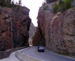
Highway 93 is a north-south route through the southeastern part of the province. Like Highway 95, Highway 93 takes its number from a U.S. Highway that it connects with at the Canada
-U.S.
boundary. The Highway first opened in 1953 from the international border to Elko
, on the Crowsnest Highway
, but it did not follow its current route from the border until 1958. One year later, Highway 93 was extended from Elko along the Crowsnest and Highway 95 to its current length through Radium Hot Springs
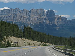
to where it crosses the Continental Divide
into Alberta
at Vermilion Pass
, where it continues as Alberta Highway 93 until its terminus at the junction with the Yellowhead Highway
in Jasper
. Before 1959, the stretch of Highway 93 east of Radium
had a designation of '1B', reflecting its connection to the Trans-Canada Highway
within Alberta at Castle Junction
. This section is also called The Banff-Windermere Parkway.
 From the international border crossing at Roosville
, the 317 km (197 mi) long Highway 93 parallels the eastern shore of Lake Koocanusa
for 36 km (22 mi) to where it meets the Crowsnest Highway at Elko. The Crowsnest carries Highway 93 west for 53 km (33 mi) to where it is handed off to Highway 95 just south of Fort Steele
. Highway 95 carries Highway 93 north for another 134 km (83 mi) along the Columbia River
to where Highway 95 diverges north at Radium Hot Springs. Highway 93 proceeds east from Radium Hot Springs for 1 km (about ½ mi) to the western gate of Kootenay National Park
. Through the park, the highway travels northeast along the Kootenay and Vermilion rivers for 93 km (58 mi) to Vermilion Pass
and the Alberta
border, where it is continued as Alberta Highway 93.
Canada
Canada is a North American country consisting of ten provinces and three territories. Located in the northern part of the continent, it extends from the Atlantic Ocean in the east to the Pacific Ocean in the west, and northward into the Arctic Ocean...
-U.S.
United States
The United States of America is a federal constitutional republic comprising fifty states and a federal district...
boundary. The Highway first opened in 1953 from the international border to Elko
Elko, British Columbia
Elko is located at the junction Highway 93 and Crowsnest Highway 3, to the north of the Roosville Canadian-USA border crossing. Elko is situated in a narrow valley in the rugged Canadian Rocky Mountains, in the heart of southeast British Columbia....
, on the Crowsnest Highway
Crowsnest Highway
The Crowsnest Highway, also known as the Interprovincial or, in British Columbia, the Southern Trans-Provincial, is an east-west highway, in length, through the southern parts of British Columbia and Alberta, providing the shortest highway connection between British Columbia's Lower Mainland and...
, but it did not follow its current route from the border until 1958. One year later, Highway 93 was extended from Elko along the Crowsnest and Highway 95 to its current length through Radium Hot Springs
Radium Hot Springs, British Columbia
Radium Hot Springs is a village of approximately 800 people situated in the East Kootenay region of British Columbia. The village is named for the hot springs located in the nearby Kootenay National Park...
to where it crosses the Continental Divide
Continental Divide
The Continental Divide of the Americas, or merely the Continental Gulf of Division or Great Divide, is the name given to the principal, and largely mountainous, hydrological divide of the Americas that separates the watersheds that drain into the Pacific Ocean from those river systems that drain...
into Alberta
Alberta
Alberta is a province of Canada. It had an estimated population of 3.7 million in 2010 making it the most populous of Canada's three prairie provinces...
at Vermilion Pass
Vermilion Pass
Vermilion Pass is a high mountain pass in the Canadian Rockies, traversing the continental divide. It connects Kootenay National Park in the province of British Columbia with Banff National Park in Alberta.-External links:*...
, where it continues as Alberta Highway 93 until its terminus at the junction with the Yellowhead Highway
Yellowhead Highway
The Yellowhead Highway is a major east-west highway connecting the four western Canadian provinces of British Columbia, Alberta, Saskatchewan, and Manitoba. Although part of the Trans-Canada Highway system, the highway should not be confused with the more southerly, originally-designated...
in Jasper
Jasper, Alberta
Jasper is a specialized municipality in western Alberta, Canada. It is the commercial centre of Jasper National Park, located in the Canadian Rockies in the Athabasca River valley....
. Before 1959, the stretch of Highway 93 east of Radium
Radium Hot Springs, British Columbia
Radium Hot Springs is a village of approximately 800 people situated in the East Kootenay region of British Columbia. The village is named for the hot springs located in the nearby Kootenay National Park...
had a designation of '1B', reflecting its connection to the Trans-Canada Highway
Trans-Canada Highway
The Trans-Canada Highway is a federal-provincial highway system that joins the ten provinces of Canada. It is, along with the Trans-Siberian Highway and Australia's Highway 1, one of the world's longest national highways, with the main route spanning 8,030 km...
within Alberta at Castle Junction
Castle Junction
Castle Junction, also known as the locale of Castle Mountain, is a highway junction where the north extent of British Columbia Highway 93 intersects with Alberta Highway 1 , the Bow River, the historic CPR rail line, and Highway 1A in Banff National Park, Alberta...
. This section is also called The Banff-Windermere Parkway.
Route details
Roosville, British Columbia
Roosville, British Columbia, Canada is a tiny farming community bordering the U.S. state of Montana near Lake Koocanusa, at the southeast corner of Tobacco Plains Indian Reserve No. 2. The Roosville border crossing is a primary entry into Southeast British Columbia from Northwest Montana. The name...
, the 317 km (197 mi) long Highway 93 parallels the eastern shore of Lake Koocanusa
Lake Koocanusa
Lake Koocanusa is a reservoir in British Columbia and Montana formed by the damming of the Kootenai River by the Libby Dam in 1975....
for 36 km (22 mi) to where it meets the Crowsnest Highway at Elko. The Crowsnest carries Highway 93 west for 53 km (33 mi) to where it is handed off to Highway 95 just south of Fort Steele
Fort Steele, British Columbia
Fort Steele is a heritage town in the East Kootenay region of British Columbia, Canada. It is located north of the Crowsnest Highway along Highways 93 and 95, northeast of Cranbrook.-History:...
. Highway 95 carries Highway 93 north for another 134 km (83 mi) along the Columbia River
Columbia River
The Columbia River is the largest river in the Pacific Northwest region of North America. The river rises in the Rocky Mountains of British Columbia, Canada, flows northwest and then south into the U.S. state of Washington, then turns west to form most of the border between Washington and the state...
to where Highway 95 diverges north at Radium Hot Springs. Highway 93 proceeds east from Radium Hot Springs for 1 km (about ½ mi) to the western gate of Kootenay National Park
Kootenay National Park
Kootenay National Park is located in southeastern British Columbia Canada covering in the Canadian Rockies and forms part of a World Heritage Site. The park ranges in elevation from at the south-west park entrance to at Deltaform Mountain...
. Through the park, the highway travels northeast along the Kootenay and Vermilion rivers for 93 km (58 mi) to Vermilion Pass
Vermilion Pass
Vermilion Pass is a high mountain pass in the Canadian Rockies, traversing the continental divide. It connects Kootenay National Park in the province of British Columbia with Banff National Park in Alberta.-External links:*...
and the Alberta
Alberta
Alberta is a province of Canada. It had an estimated population of 3.7 million in 2010 making it the most populous of Canada's three prairie provinces...
border, where it is continued as Alberta Highway 93.