
British Columbia provincial highway 4
Encyclopedia
British Columbia
Highway 4, known locally as the Alberni Highway to the east of Port Alberni
and the Pacific Rim Highway to the west, is the longest east-west main vehicle route on Vancouver Island
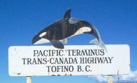
, with a total length of 163 km (101 mi). The highway to Port Alberni was completed in 1942, has been designated as Highway 4 since 1953, and was extended in 1961 to the small community of Tofino
, on the west coast of the Island.
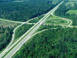
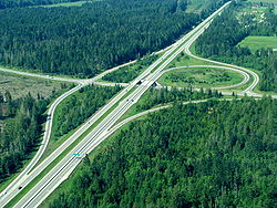 Highway 4's eastern terminus is at an intersection with Highway 19A in Qualicum Beach
, where the highway is known as Memorial Avenue. The highway starts off travelling due south for 2 km (1¼ mi) to an interchange with Highway 19. Another 2 km (1¼ mi) south of the interchange with Highway 19, Highway 4 meets a junction with an older Alberni Highway segment, now known as Highway 4A, at the small community of Coombs
. Highway 4 veers directly west upon meeting this junction.
The majority of Highway 4's length is composed of a two-lane configuration. An abandoned spur of the E&N Railway parallels Highway 4 all the way from the coast to the city of Port Alberni.
West of Coombs Junction, Highway 4 travels for 11 km (7 mi) before meeting Cameron Lake
. Highway 4 hugs the shore of Cameron Lake for 5 km, then winds its way through MacMillan Provincial Park
, which includes the well-known area of Cathedral Grove. After Cameron Lake, Highway 4 climbs for 8 km to the Port Alberni Summit—known by locals as "The Hump"—and then descends for 6 km to a spur that travels into the city centre of Port Alberni. Highway 4 actually enters the city limits of Port Alberni 2 km (1¼ mi) west of the main spur into the city, and 5 km (3 mi) later, exits Port Alberni via a bridge over the Somass River
.
 6 km (4 mi) west of the Somass River
crossing, Highway 4 reaches the shore of Sproat Lake, following the lake shore west for 24 km (15 mi). Highway 4 goes through Sutton Pass another 10 km (6 mi) later and turns toward the south-southwest. This very winding bearing of Highway 4, which features very steep grades, continues for 23 km (14 mi) before reaching the southeast shore of Kennedy Lake. Highway 4 then follows the shore of Kennedy Lake southwest for 19 km (12 mi), then reaches a junction with a spur into the settlement of Ucluelet 5 km (3 mi) later. At the Ucluelet junction, Highway 4 then makes a ninety-degree turn towards the northwest. 1 km (0.6 mi) later, Highway 4 enters the Long Beach arm of Pacific Rim National Park. Highway 4 goes through the national park for 22 km (14 mi) northwest, finally terminating 11 km (7 mi) later at Tofino.
----
Highway 4A is the previous alignment of Highway 4 east of Coombs
. The '4A' designation was originally assigned in 1968 to the current section of Highway 4 between Coombs and Qualicum Beach
. The 4 and 4A alignments east and north of Coombs, respectively, switched designations when the Parksville
to Mud Bay section of the Inland Island Highway was completed in 1996. This older spur of Highway 4 terminates in the east at Parksville, 10 km (6 mi) from Coombs.

British Columbia
British Columbia is the westernmost of Canada's provinces and is known for its natural beauty, as reflected in its Latin motto, Splendor sine occasu . Its name was chosen by Queen Victoria in 1858...
Highway 4, known locally as the Alberni Highway to the east of Port Alberni
Port Alberni, British Columbia
Port Alberni is a city located in the province of British Columbia in Canada. It is the location of the head offices of the Alberni-Clayoquot Regional District. The city has a total population of 17,743, and the census agglomeration area a total of 25,396....
and the Pacific Rim Highway to the west, is the longest east-west main vehicle route on Vancouver Island
Vancouver Island
Vancouver Island is a large island in British Columbia, Canada. It is one of several North American locations named after George Vancouver, the British Royal Navy officer who explored the Pacific Northwest coast of North America between 1791 and 1794...
, with a total length of 163 km (101 mi). The highway to Port Alberni was completed in 1942, has been designated as Highway 4 since 1953, and was extended in 1961 to the small community of Tofino
Tofino, British Columbia
Tofino is a district of about 1,650 residents on the west coast of Vancouver Island, in British Columbia, Canada, located at the western terminus of Highway 4, on the tip of the Esowista Peninsula, at the southern edge of Clayoquot Sound....
, on the west coast of the Island.
Route details
Qualicum Beach, British Columbia
Qualicum Beach is a town in the Regional District of Nanaimo, British Columbia, Canada. As of the 2006 census, the town had 8,502 people.On the Strait of Georgia on the north-eastern coast of Vancouver Island in the shadow of Mount Arrowsmith, the community has been a popular tourist destination,...
, where the highway is known as Memorial Avenue. The highway starts off travelling due south for 2 km (1¼ mi) to an interchange with Highway 19. Another 2 km (1¼ mi) south of the interchange with Highway 19, Highway 4 meets a junction with an older Alberni Highway segment, now known as Highway 4A, at the small community of Coombs
Coombs, British Columbia
Coombs is a small community on Vancouver Island in British Columbia, situated on provincial highway 4A approximately west of Parksville. Coombs is home to approximately 1,327 people and is renowned for its Old Country Market , Butterfly World , Jessica's waterslide, Coombs is a small community on...
. Highway 4 veers directly west upon meeting this junction.
The majority of Highway 4's length is composed of a two-lane configuration. An abandoned spur of the E&N Railway parallels Highway 4 all the way from the coast to the city of Port Alberni.
West of Coombs Junction, Highway 4 travels for 11 km (7 mi) before meeting Cameron Lake
Cameron Lake (British Columbia)
Cameron Lake is a lake in central Vancouver Island located 15 km east of Port Alberni, on the north side of Highway 4. It has an area of 477 hectares and an elevation of 184 metres above sea level. The lake is between Mount Arrowsmith to the south and Mount Wesley to the north...
. Highway 4 hugs the shore of Cameron Lake for 5 km, then winds its way through MacMillan Provincial Park
MacMillan Provincial Park
MacMillan Provincial Park is a 301 hectare provincial park in British Columbia, Canada. Located 25 km west of Qualicum Beach and 16 km east of Port Alberni, the park straddles Highway 4 in central Vancouver Island. It is nestled on the western shore of Cameron Lake, and protects the...
, which includes the well-known area of Cathedral Grove. After Cameron Lake, Highway 4 climbs for 8 km to the Port Alberni Summit—known by locals as "The Hump"—and then descends for 6 km to a spur that travels into the city centre of Port Alberni. Highway 4 actually enters the city limits of Port Alberni 2 km (1¼ mi) west of the main spur into the city, and 5 km (3 mi) later, exits Port Alberni via a bridge over the Somass River
Somass River
Somass River is a river on Vancouver Island, in the Canadian province of British Columbia. Its drainage basin is in size.The river's name comes from a Nuu-chah-nulth word meaning "washing".-Course:...
.
Somass River
Somass River is a river on Vancouver Island, in the Canadian province of British Columbia. Its drainage basin is in size.The river's name comes from a Nuu-chah-nulth word meaning "washing".-Course:...
crossing, Highway 4 reaches the shore of Sproat Lake, following the lake shore west for 24 km (15 mi). Highway 4 goes through Sutton Pass another 10 km (6 mi) later and turns toward the south-southwest. This very winding bearing of Highway 4, which features very steep grades, continues for 23 km (14 mi) before reaching the southeast shore of Kennedy Lake. Highway 4 then follows the shore of Kennedy Lake southwest for 19 km (12 mi), then reaches a junction with a spur into the settlement of Ucluelet 5 km (3 mi) later. At the Ucluelet junction, Highway 4 then makes a ninety-degree turn towards the northwest. 1 km (0.6 mi) later, Highway 4 enters the Long Beach arm of Pacific Rim National Park. Highway 4 goes through the national park for 22 km (14 mi) northwest, finally terminating 11 km (7 mi) later at Tofino.
----
Highway 4A is the previous alignment of Highway 4 east of Coombs
Coombs, British Columbia
Coombs is a small community on Vancouver Island in British Columbia, situated on provincial highway 4A approximately west of Parksville. Coombs is home to approximately 1,327 people and is renowned for its Old Country Market , Butterfly World , Jessica's waterslide, Coombs is a small community on...
. The '4A' designation was originally assigned in 1968 to the current section of Highway 4 between Coombs and Qualicum Beach
Qualicum Beach, British Columbia
Qualicum Beach is a town in the Regional District of Nanaimo, British Columbia, Canada. As of the 2006 census, the town had 8,502 people.On the Strait of Georgia on the north-eastern coast of Vancouver Island in the shadow of Mount Arrowsmith, the community has been a popular tourist destination,...
. The 4 and 4A alignments east and north of Coombs, respectively, switched designations when the Parksville
Parksville, British Columbia
-Demographics:Parksville had a population of 10,993 people in 2006, which was an increase of 6.5% from the 2001 census count. The median household income in 2006 for Parksville was $55,524, which is below the British Columbia provincial average of $62,346....
to Mud Bay section of the Inland Island Highway was completed in 1996. This older spur of Highway 4 terminates in the east at Parksville, 10 km (6 mi) from Coombs.