

Breña
Encyclopedia
Breña is a district
of the Lima Province
in Peru
. It is part of Lima
city metropolitan area.
Officially established as a district on July 15, 1949, the current mayor
(alcalde
) of Breña is José Gordillo Abad. The district's postal code
is LIM05. If you live in the USA and want to send a letter, gift etc to a friend, you only have to put 05 and not LIM05. An example is:
John Doe
444 Arequipa Ave.
Lima, Peru 05
In the North area of the first boundary, was the huaca or complex of Makatampu (Macatambo), constructed during the Early Interval associated with the Lima or Maranga cultures (0-600 d.C.) Made of adobitos, adobones(Mud Bricks) and stones, with intrusive burials corresponding to the Late Interval (900-1470 d.C.). The location was the old property of the Count de las Torres, towards the north of 27th block of the Argentina avenue. This huaca disappeared by urban expansion between years 1940 and 1948.
To the south of the first district boundary is the archaeological complex Mateo Salado or Huaca de Azcona, who would have been host to the Curacazgo of Lima. Constituted by five constructed pyramids with big mudwalls, measures around 1,2 hectares. It is considered that it is of the Late Interval ( 900 DC - 1470 DC) and the Late Horizon Horizon (1470 DC -1532 DC). Formerly it was connected by a closed walled street with the archaeological group of Maranga. There are also references of the existence of a small huaca (Panteoncito) towards the third block of Brazil avenue.
The viceroy Melchor of Navarra y Rocaful, Duke of the Palata, insisted on the construction. The work began in 1685 and was inaugurated in 1687. The wall was more than 5 meters wide and 4,5 of height, and extended approximately 11,700 meters. It had 34 defensive bastions and 5 accesses to the city.
In the map of Lima elaborated by State Engineer Santiago M. Basurco, dated 1904, towards the west of the avenue Alfonso Ugarte is located the place called Chacra Colorada. Following towards the south the same avenue and bordering the Piérola avenue (Brazil), is the Breña farm (from where the name of the district comes); more to the south the Desamparados and Azcona farms are shown.
In the topographic plane of Lima, Callao and its environs (1907), appear the denominated places Breña, Chacra Colorada, Azcona (sic) and Rios. The river (irrigation channel) Magdalena or Maranga crosses from north to south, dividing Azcona and Chacra Colorada, where it would exists now the Aguarico street, follow by Napo and ending at the Avenida del rio, which determined the layout of the urbanizations and streets. This is clearly seen in the map of Ricardo Tizón I Bueno, civil engineer and surveyor (1908).
On the same year it is the map of the Electrical Company Empresas Eléctricas Asociadas (by engineer Enrique E. Silgado), that shows first all the surface of Lima, Callao, beaches and farms. Between these, they appear Breña, Chacra Colorada, Azcona, Chacra Rios and Desamparados. At this time constructions on the west side of Avenida Circumvalacion, and on the zone closest to the city on the Avenida Progreso (Venezuela). On the first centenary of the battle of Ayacucho the panoramic map of Lima (1924), the Legend hides the lots between the highway to Callao (Colonial, today Benavides) and the avenue Breña (Arica).
 During the Government of General Manuel Odría Amoretti, by Law Nº 11059 of July 15, 1949 the Breña district was created. It took the name of the property of the same name, that corresponds to the Spanish word meaning "earth between rocks and populated with weeds" and it does not make reference, as many think to Marshal Andrés A. Cáceres nor to the Campaign of the Breña.
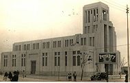
Breña was thought like a large industrial zone that of this a went from avenue Alfonso Ugarte to the west to Callao, and from north to south from the Rimac river to Santa Beatriz farm. The relative economic bonanza of Peru as a result of World War II and the Korean War, allowed the planning for industry and worker quarters for this district. Worth to mention one of the catholic churches was devised like art Deco monument.
Unfortunately the second half of the 20th century did live to expectations. The district, that included the urbanizations Breña, Chacra Colorada, Azcona, Chacra Rios, Dos de Mayo, Conde de las Torres and Wiese, was trimmed one decade later, losing almost half of its extension.
of 3.22 km². Its administrative center is located 102 meters above sea level
.
, the district has 81909 inhabitants (enumerated) and a population density of 25438,6 persons/km². In 2007, there were 22189 households in the district.
Currently mayor:
Districts of Peru
The districts of Peru are the third-level country subdivisions of Peru. They are subdivisions of the provinces, which in turn are subdivisions of the larger regions or departments...
of the Lima Province
Lima Province
Lima Province is located in the central coast of Peru and is the only province in the country not belonging to any of the twenty-five regions. Its capital is Lima, which is also the nation's capital....
in Peru
Peru
Peru , officially the Republic of Peru , is a country in western South America. It is bordered on the north by Ecuador and Colombia, on the east by Brazil, on the southeast by Bolivia, on the south by Chile, and on the west by the Pacific Ocean....
. It is part of Lima
Lima
Lima is the capital and the largest city of Peru. It is located in the valleys of the Chillón, Rímac and Lurín rivers, in the central part of the country, on a desert coast overlooking the Pacific Ocean. Together with the seaport of Callao, it forms a contiguous urban area known as the Lima...
city metropolitan area.
Officially established as a district on July 15, 1949, the current mayor
Mayor
In many countries, a Mayor is the highest ranking officer in the municipal government of a town or a large urban city....
(alcalde
Alcalde
Alcalde , or Alcalde ordinario, is the traditional Spanish municipal magistrate, who had both judicial and administrative functions. An alcalde was, in the absence of a corregidor, the presiding officer of the Castilian cabildo and judge of first instance of a town...
) of Breña is José Gordillo Abad. The district's postal code
Postal code
A postal code is a series of letters and/or digits appended to a postal address for the purpose of sorting mail. Once postal codes were introduced, other applications became possible.In February 2005, 117 of the 190 member countries of the Universal Postal Union had postal code systems...
is LIM05. If you live in the USA and want to send a letter, gift etc to a friend, you only have to put 05 and not LIM05. An example is:
John Doe
444 Arequipa Ave.
Lima, Peru 05
Pre-Hispanic Period
In pre-Hispanic times this zone would have been part of Curacazgo or Señorío of Ichma (Lima), with center in Pachacámac, that extended from the river and valley of Lurín to the Rímac. The small Curacazgos were formed in around the irrigation channels that allowed ample agricultural zones to maintain settlers. One of these was the channel of the Magdalena, that had its origin in the Rímac and started behind the present Palace of Government, went north to south crossing the district (by the current streets of Aguarico and Loreto, towards the avenue of the Rio de Pueblo Libre).In the North area of the first boundary, was the huaca or complex of Makatampu (Macatambo), constructed during the Early Interval associated with the Lima or Maranga cultures (0-600 d.C.) Made of adobitos, adobones(Mud Bricks) and stones, with intrusive burials corresponding to the Late Interval (900-1470 d.C.). The location was the old property of the Count de las Torres, towards the north of 27th block of the Argentina avenue. This huaca disappeared by urban expansion between years 1940 and 1948.
To the south of the first district boundary is the archaeological complex Mateo Salado or Huaca de Azcona, who would have been host to the Curacazgo of Lima. Constituted by five constructed pyramids with big mudwalls, measures around 1,2 hectares. It is considered that it is of the Late Interval ( 900 DC - 1470 DC) and the Late Horizon Horizon (1470 DC -1532 DC). Formerly it was connected by a closed walled street with the archaeological group of Maranga. There are also references of the existence of a small huaca (Panteoncito) towards the third block of Brazil avenue.
Colonial Period
From 1618 the construction of a wall to defend the city of Lima from the possible pirate or Indian attacks had been requested from the population of Lima. More than half century later it was the Flemish presbyter Jean Raymond Coninck born in Mechelen, known astrologist of the Kingdom, that executed the project. He arrived at Peru in 1655 and due to his unique architectonic knowledge for his time because he had been disciple of the Jesuit scientists Gregorio of San Vicente and Andrés Jacquet.The viceroy Melchor of Navarra y Rocaful, Duke of the Palata, insisted on the construction. The work began in 1685 and was inaugurated in 1687. The wall was more than 5 meters wide and 4,5 of height, and extended approximately 11,700 meters. It had 34 defensive bastions and 5 accesses to the city.
Republican Period
Lima was a walled city still in 1862, as is it shown on the 1862 map of the city made by Colonel Mariano Bolognesi. On December 2, 1869 Peruvian president Jose Balta signs the decree by which the walls are taken down, to allow urban growth. In 1878, the traveler Edmundo Cotteau makes reference to that the walls had been demolished to make room for new streets. According to P. V. Jouanny map printed by F. Dafour in Paris (1880), the city of Lima finished by the west in the avenue Circumvallation (Alfonso Ugarte), drawn up on the space that had occupied the walls of the west.In the map of Lima elaborated by State Engineer Santiago M. Basurco, dated 1904, towards the west of the avenue Alfonso Ugarte is located the place called Chacra Colorada. Following towards the south the same avenue and bordering the Piérola avenue (Brazil), is the Breña farm (from where the name of the district comes); more to the south the Desamparados and Azcona farms are shown.
In the topographic plane of Lima, Callao and its environs (1907), appear the denominated places Breña, Chacra Colorada, Azcona (sic) and Rios. The river (irrigation channel) Magdalena or Maranga crosses from north to south, dividing Azcona and Chacra Colorada, where it would exists now the Aguarico street, follow by Napo and ending at the Avenida del rio, which determined the layout of the urbanizations and streets. This is clearly seen in the map of Ricardo Tizón I Bueno, civil engineer and surveyor (1908).
On the same year it is the map of the Electrical Company Empresas Eléctricas Asociadas (by engineer Enrique E. Silgado), that shows first all the surface of Lima, Callao, beaches and farms. Between these, they appear Breña, Chacra Colorada, Azcona, Chacra Rios and Desamparados. At this time constructions on the west side of Avenida Circumvalacion, and on the zone closest to the city on the Avenida Progreso (Venezuela). On the first centenary of the battle of Ayacucho the panoramic map of Lima (1924), the Legend hides the lots between the highway to Callao (Colonial, today Benavides) and the avenue Breña (Arica).
Foundation as a District
Breña was thought like a large industrial zone that of this a went from avenue Alfonso Ugarte to the west to Callao, and from north to south from the Rimac river to Santa Beatriz farm. The relative economic bonanza of Peru as a result of World War II and the Korean War, allowed the planning for industry and worker quarters for this district. Worth to mention one of the catholic churches was devised like art Deco monument.
Unfortunately the second half of the 20th century did live to expectations. The district, that included the urbanizations Breña, Chacra Colorada, Azcona, Chacra Rios, Dos de Mayo, Conde de las Torres and Wiese, was trimmed one decade later, losing almost half of its extension.
Geography
The district has a total land areaArea
Area is a quantity that expresses the extent of a two-dimensional surface or shape in the plane. Area can be understood as the amount of material with a given thickness that would be necessary to fashion a model of the shape, or the amount of paint necessary to cover the surface with a single coat...
of 3.22 km². Its administrative center is located 102 meters above sea level
Sea level
Mean sea level is a measure of the average height of the ocean's surface ; used as a standard in reckoning land elevation...
.
Boundaries
- North, East and West: downtown LimaLima DistrictLima is a district of the Lima Province in Peru. It is not where the inner city zone of Lima, the country's capital city, is located, San Isidro District being such area in Lima....
- Southeast: Jesús María
- Southwest: Pueblo LibrePueblo LibrePueblo Libre is a district of the Lima Province in Peru and one of the districts that comprise the city of Lima. Its name, which means Free Town or Free People, was granted by José de San Martín on April 10, 1822 as a recognition of the patriotism shown by its inhabitants during the Peruvian War of...
Demographics
According to XI Population Census 2007 organized by the INEIInstituto Nacional de Estadística e Informática
The Instituto Nacional de Estadística e Informática is a semi-autonomous Peruvian government agency which coordinates, compiles, and evaluates statistical information for the country...
, the district has 81909 inhabitants (enumerated) and a population density of 25438,6 persons/km². In 2007, there were 22189 households in the district.
Mayors
Main article: Mayors of Breña DistrictCurrently mayor:
- José Gordillo Abad (2007–2010)